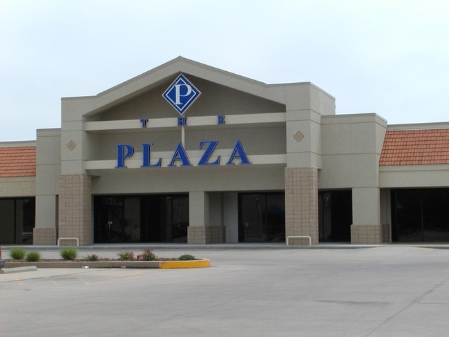
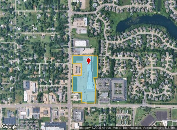
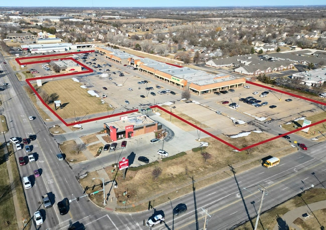
Property Record
620 N Andover Rd, Andover, KS 67002
NEARBY LISTINGS FOR SALE OR LEASE
Property Detail
620 N Andover Rd
Wichita, KS
Meadows (The) 2Nd Add
304-17-0-30-03-002-00-0
MEADOWS, (THE) 2ND ADD, S17, T27, R03E, ACRES 9.6, LT 3 EXC BEG SE/C LT 2 S5.92 W190 N5.92 E190 TO POB & EXC BEG SE/C LT 3 W4
Homeimprovementgardencenterhomedepotlowes
Butler
X
Kansas
20173C0384G
2-3
2024
9.60 AC
2025
Andover/East
020208
Wichita
70,856 SF
DEMOGRAPHICS near 620 N Andover Rd
1 Mile
3 Mile
5 Mile
2024 Total Population
6,194
24,567
46,856
2029 Population
6,377
25,136
47,904
Pop Growth 2024-2029
+ 2.95%
+ 2.32%
+ 2.24%
Average Age
38
38
39
2024 Total Households
2,162
8,490
16,386
HH Growth 2024-2029
+ 2.96%
+ 2.26%
+ 2.19%
Median Household Inc
$98,010
$111,102
$109,477
Avg Household Size
2.80
2.80
2.80
2024 Avg HH Vehicles
2.00
2.00
2.00
Median Home Value
$264,115
$284,675
$285,659
Median Year Built
1995
1999
2000
Nearby Places
Map Layers
Map Styles
 Street
 Aerial
- Restaurants
- Banks
- Shops
- Fitness
- Groceries
PUBLIC TRANSPORTATION
AIRPORT
Wichita Dwight D Eisenhower Ntl
DRIVE
WALK
Distance
Wichita Dwight D Eisenhower Ntl
27 min
18.8 mi
Freight Ports
Tulsa Port Of Catoosa
DRIVE
WALK
Distance
Tulsa Port Of Catoosa
214 min
200.3 mi
SALE & LEASE HISTORY
LISTING DATE
SALE/LEASE

Sep 25, 2016
For Lease
Mar 15, 2018
For Lease
Feb 08, 2021
For Lease
Dec 23, 2019
For Lease
Nearby Properties
Address
Land Use
TOTAL SIZE
Lot Size
Zoning
Address
Land Use
TOTAL SIZE
Lot Size
Zoning
121.30 AC
Address
Land Use
TOTAL SIZE
Lot Size
Zoning
126.70 AC
Address
Land Use
TOTAL SIZE
Lot Size
Zoning
32.40 AC
Address
Land Use
TOTAL SIZE
Lot Size
Zoning
117,375 SF
20.60 AC
Address
Land Use
TOTAL SIZE
Lot Size
Zoning
123,253 SF
14.60 AC
Address
Land Use
TOTAL SIZE
Lot Size
Zoning
97,612 SF
28.40 AC
Address
Land Use
TOTAL SIZE
Lot Size
Zoning
71,058 SF
17.47 AC
SF-5
Address
Land Use
TOTAL SIZE
Lot Size
Zoning
19.70 AC
Address
Land Use
TOTAL SIZE
Lot Size
Zoning
16.80 AC
Address
Land Use
TOTAL SIZE
Lot Size
Zoning
15,597 SF
67.40 AC
Address
Land Use
TOTAL SIZE
Lot Size
Zoning
37,934 SF
24.82 AC
SF-5
Address
Land Use
TOTAL SIZE
Lot Size
Zoning
20.60 AC
Address
Land Use
TOTAL SIZE
Lot Size
Zoning
43,148 SF
7.84 AC
SF-5
Address
Land Use
TOTAL SIZE
Lot Size
Zoning
86,955 SF
Address
Land Use
TOTAL SIZE
Lot Size
Zoning
14,337 SF
3 AC
Address
Land Use
TOTAL SIZE
Lot Size
Zoning
24.20 AC
Address
Land Use
TOTAL SIZE
Lot Size
Zoning
47,234 SF
8.70 AC
Address
Land Use
TOTAL SIZE
Lot Size
Zoning
14,582 SF
5.30 AC
Address
Land Use
TOTAL SIZE
Lot Size
Zoning
38,759 SF
14.86 AC
SF-5
Address
Land Use
TOTAL SIZE
Lot Size
Zoning
20,113 SF
2.90 AC
Address
Land Use
TOTAL SIZE
Lot Size
Zoning
32,561 SF
18.04 AC
SF-5
Address
Land Use
TOTAL SIZE
Lot Size
Zoning
70,937 SF
9.60 AC
Address
Land Use
TOTAL SIZE
Lot Size
Zoning
83,625 SF
11 AC
Address
Land Use
TOTAL SIZE
Lot Size
Zoning
199,945 SF
3.40 AC
Address
Land Use
TOTAL SIZE
Lot Size
Zoning
8,993 SF
1.70 AC
Address
Land Use
TOTAL SIZE
Lot Size
Zoning
129,575 SF
10.29 AC
LC
Address
Land Use
TOTAL SIZE
Lot Size
Zoning
20,744 SF
2.50 AC
Address
Land Use
TOTAL SIZE
Lot Size
Zoning
29,697 SF
6.34 AC
SF-5
Address
Land Use
TOTAL SIZE
Lot Size
Zoning
7,924 SF
12.70 AC
Address
Land Use
TOTAL SIZE
Lot Size
Zoning
174,164 SF
18.50 AC
The World's #1 Commercial Real Estate Marketplace
Connect with us
© 2026 CoStar Group
The information above has been obtained from sources believed reliable. While we do not doubt its accuracy we have not verified it and make no guarantee, warranty or representation about it. It is your responsibility to independently confirm its accuracy and completeness. Any projections, opinions, assumptions, or estimates used are for example only and do not represent the current or future performance of the property. The value of this transaction to you depends on tax and other factors which should be evaluated by your tax, financial, and legal advisors. You and your advisors should conduct a careful, independent investigation of the property to determine to your satisfaction the suitability of the property for your needs.