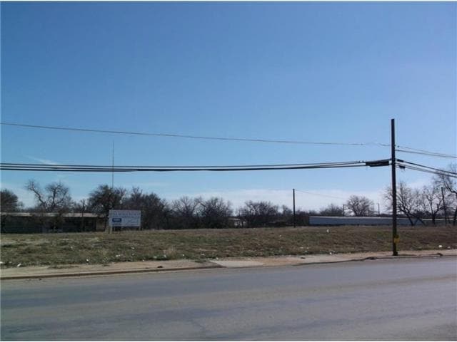
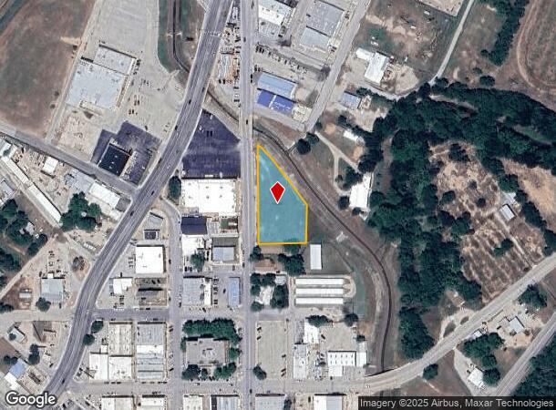
Property Record
620 N Fisk Ave, Brownwood, TX 76801
NEARBY LISTINGS FOR SALE OR LEASE
Property Detail
620 N Fisk Ave
Brownwood, TX
Brownwood Proper
51496
BROWNWOOD PROPER, BLOCK 40, J R LOONEY HIGHWAY ADDITION, BLOCK SOUTH PART OF 2, MARCUS HULING, SURVEY 51, ABSTRACT 405, ACRES
Residentialacreage
Brown
AE
Texas
48049C0376E
1.04 AC
2025
Central Texas Area
2025
Other Market Areas
950700
DEMOGRAPHICS near 620 N Fisk Ave
1 Mile
3 Mile
5 Mile
2024 Total Population
2,913
18,102
25,476
2029 Population
3,003
18,416
25,781
Pop Growth 2024-2029
+ 3.09%
+ 1.73%
+ 1.20%
Average Age
35
39
40
2024 Total Households
1,073
7,179
9,874
HH Growth 2024-2029
+ 3.45%
+ 1.71%
+ 1.20%
Median Household Inc
$32,250
$41,692
$45,900
Avg Household Size
2.20
2.40
2.40
2024 Avg HH Vehicles
1.00
2.00
2.00
Median Home Value
$72,923
$113,476
$128,499
Median Year Built
1958
1968
1973
Nearby Places
Map Layers
Map Styles
 Street
 Aerial
- Restaurants
- Banks
- Shops
- Fitness
- Groceries
SALE & LEASE HISTORY
LISTING DATE
SALE/LEASE

Sep 24, 2016
For Sale
Nearby Properties
Address
Land Use
TOTAL SIZE
Lot Size
Zoning
Address
Land Use
TOTAL SIZE
Lot Size
Zoning
261,660 SF
24.10 AC
Address
Land Use
TOTAL SIZE
Lot Size
Zoning
363,506 SF
41.50 AC
Address
Land Use
TOTAL SIZE
Lot Size
Zoning
238,790 SF
146.25 AC
Address
Land Use
TOTAL SIZE
Lot Size
Zoning
80,387 SF
9.28 AC
Address
Land Use
TOTAL SIZE
Lot Size
Zoning
150,399 SF
9.77 AC
Address
Land Use
TOTAL SIZE
Lot Size
Zoning
166,660 SF
21.40 AC
Address
Land Use
TOTAL SIZE
Lot Size
Zoning
209,198 SF
40.29 AC
Address
Land Use
TOTAL SIZE
Lot Size
Zoning
55,610 SF
15.17 AC
Address
Land Use
TOTAL SIZE
Lot Size
Zoning
63,396 SF
6.42 AC
Address
Land Use
TOTAL SIZE
Lot Size
Zoning
91,669 SF
15.77 AC
Address
Land Use
TOTAL SIZE
Lot Size
Zoning
54,873 SF
2.40 AC
Address
Land Use
TOTAL SIZE
Lot Size
Zoning
239,800 SF
20.57 AC
Address
Land Use
TOTAL SIZE
Lot Size
Zoning
47,534 SF
1.50 AC
Address
Land Use
TOTAL SIZE
Lot Size
Zoning
193,140 SF
15.71 AC
Address
Land Use
TOTAL SIZE
Lot Size
Zoning
104,482 SF
10.91 AC
Address
Land Use
TOTAL SIZE
Lot Size
Zoning
29,169 SF
2.45 AC
Address
Land Use
TOTAL SIZE
Lot Size
Zoning
164,529 SF
8.21 AC
Address
Land Use
TOTAL SIZE
Lot Size
Zoning
109,946 SF
8.79 AC
Address
Land Use
TOTAL SIZE
Lot Size
Zoning
41,564 SF
3.43 AC
Address
Land Use
TOTAL SIZE
Lot Size
Zoning
69,272 SF
36.36 AC
Address
Land Use
TOTAL SIZE
Lot Size
Zoning
43,216 SF
9.49 AC
Address
Land Use
TOTAL SIZE
Lot Size
Zoning
71,170 SF
30.26 AC
Address
Land Use
TOTAL SIZE
Lot Size
Zoning
43,156 SF
1.42 AC
Address
Land Use
TOTAL SIZE
Lot Size
Zoning
35,415 SF
1.87 AC
Address
Land Use
TOTAL SIZE
Lot Size
Zoning
45,172 SF
3.88 AC
Address
Land Use
TOTAL SIZE
Lot Size
Zoning
68,950 SF
4.27 AC
Address
Land Use
TOTAL SIZE
Lot Size
Zoning
34,440 SF
0.92 AC
Address
Land Use
TOTAL SIZE
Lot Size
Zoning
96,657 SF
7 AC
Address
Land Use
TOTAL SIZE
Lot Size
Zoning
21,210 SF
0.92 AC
Address
Land Use
TOTAL SIZE
Lot Size
Zoning
21,290 SF
98.33 AC
The World's #1 Commercial Real Estate Marketplace
Connect with us
© 2025 CoStar Group
The information above has been obtained from sources believed reliable. While we do not doubt its accuracy we have not verified it and make no guarantee, warranty or representation about it. It is your responsibility to independently confirm its accuracy and completeness. Any projections, opinions, assumptions, or estimates used are for example only and do not represent the current or future performance of the property. The value of this transaction to you depends on tax and other factors which should be evaluated by your tax, financial, and legal advisors. You and your advisors should conduct a careful, independent investigation of the property to determine to your satisfaction the suitability of the property for your needs.