Property Record
620 Spring St, North Dighton, MA 02764
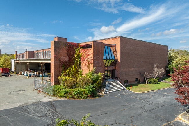

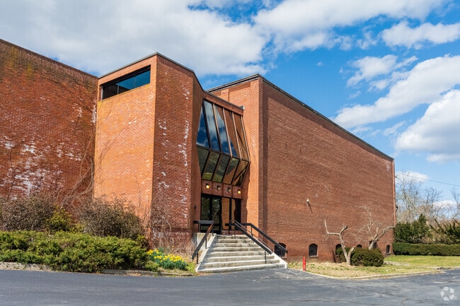
This Property Is For Sale
Property Detail
620 Spring St
Manufacturinglight
BRISTOL
I
Massachusetts
AE The base floodplain where base flood elevations are provided. AE Zones are now used on new format FIRMs instead of A1-A30 Zones.
33.75 AC
2025
Attleboro/New Bedford
2025
Boston
615100
Providence-Warwick, RI-MA
389,941 SF
DIGH-000004-000170
NEARBY LISTINGS FOR SALE OR LEASE
DEMOGRAPHICS near 620 Spring St
1 mile
3 mile
5 mile
2025 Total Population
2,805
27,557
67,190
2030 Population
2,836
27,934
68,188
Pop Growth 2025-2030
+ 1.11%
+ 1.37%
+ 1.49%
Average Age
42
40
41
2025 Total Households
1,070
10,884
26,170
HH Growth 2025-2030
+ 1.31%
+ 1.45%
+ 1.52%
Median Household Inc
$96,128
$75,193
$81,987
Avg Household Size
2.60
2.50
2.50
2025 Avg HH Vehicles
2.00
2.00
2.00
Median Home Value
$456,354
$447,765
$444,954
Median Year Built
1964
1967
1969
Nearby Places
Map Layers
Map Styles
 Street
 Aerial
Layers
 Traffic
 Biking
Places
Listings with unknown addresses are not visible on the map
- Restaurants
- Banks
- Shops
- Fitness
- Groceries
PUBLIC TRANSPORTATION
AIRPORT
Rhode Island Tf Green International
Drive
Walk
Distance
Rhode Island Tf Green International
44 min
24.7 mi
Freight Ports
Port of New Bedford Harbor
Drive
Walk
Distance
Port of New Bedford Harbor
38 min
25.5 mi
Nearby Properties
Address
Land Use
TOTAL SIZE
Lot Size
Zoning
Address
Land Use
TOTAL SIZE
Lot Size
Zoning
130,851 SF
24.43 AC
URBRES
Address
Land Use
TOTAL SIZE
Lot Size
Zoning
174,000 SF
62.88 AC
R1
Address
Land Use
TOTAL SIZE
Lot Size
Zoning
37.62 AC
URBRES
Address
Land Use
TOTAL SIZE
Lot Size
Zoning
5.20 AC
URBRES
Address
Land Use
TOTAL SIZE
Lot Size
Zoning
52,042 SF
59.53 AC
OPSPAC
Address
Land Use
TOTAL SIZE
Lot Size
Zoning
76,960 SF
23.40 AC
C
Address
Land Use
TOTAL SIZE
Lot Size
Zoning
44,581 SF
14.60 AC
RURRES
Address
Land Use
TOTAL SIZE
Lot Size
Zoning
61,128 SF
0.98 AC
Address
Land Use
TOTAL SIZE
Lot Size
Zoning
3 AC
URBRES
Address
Land Use
TOTAL SIZE
Lot Size
Zoning
5.60 AC
INDUST
Address
Land Use
TOTAL SIZE
Lot Size
Zoning
24 AC
HIWABZ
Address
Land Use
TOTAL SIZE
Lot Size
Zoning
164,658 SF
15.18 AC
BIZDIS
Address
Land Use
TOTAL SIZE
Lot Size
Zoning
29,400 SF
12.91 AC
I
Address
Land Use
TOTAL SIZE
Lot Size
Zoning
11.82 AC
URBRES
Address
Land Use
TOTAL SIZE
Lot Size
Zoning
4.53 AC
URBRES
Address
Land Use
TOTAL SIZE
Lot Size
Zoning
244,320 SF
13.66 AC
INDUST
Address
Land Use
TOTAL SIZE
Lot Size
Zoning
91,289 SF
3.82 AC
URBRES
Address
Land Use
TOTAL SIZE
Lot Size
Zoning
5,616 SF
10 AC
URBRES
Address
Land Use
TOTAL SIZE
Lot Size
Zoning
5.26 AC
URBRES
Address
Land Use
TOTAL SIZE
Lot Size
Zoning
120 AC
OPSPAC
Address
Land Use
TOTAL SIZE
Lot Size
Zoning
58,078 SF
6.10 AC
HIWABZ
Address
Land Use
TOTAL SIZE
Lot Size
Zoning
72,833 SF
6.98 AC
HIWABZ
Address
Land Use
TOTAL SIZE
Lot Size
Zoning
50 AC
URBRES
Address
Land Use
TOTAL SIZE
Lot Size
Zoning
132,574 SF
7.70 AC
RURRES
Address
Land Use
TOTAL SIZE
Lot Size
Zoning
17.50 AC
I
Address
Land Use
TOTAL SIZE
Lot Size
Zoning
142,832 SF
6.57 AC
BIZDIS
Address
Land Use
TOTAL SIZE
Lot Size
Zoning
10,080 SF
6.70 AC
R1
Address
Land Use
TOTAL SIZE
Lot Size
Zoning
35,717 SF
44 AC
I
Address
Land Use
TOTAL SIZE
Lot Size
Zoning
6,880 SF
53.30 AC
C
Address
Land Use
TOTAL SIZE
Lot Size
Zoning
36,958 SF
1.60 AC
URBRES
The World's #1 Commercial Real Estate Marketplace
Connect with us
© 2026 CoStar Group
The information above has been obtained from sources believed reliable. While we do not doubt its accuracy we have not verified it and make no guarantee, warranty or representation about it. It is your responsibility to independently confirm its accuracy and completeness. Any projections, opinions, assumptions, or estimates used are for example only and do not represent the current or future performance of the property. The value of this transaction to you depends on tax and other factors which should be evaluated by your tax, financial, and legal advisors. You and your advisors should conduct a careful, independent investigation of the property to determine to your satisfaction the suitability of the property for your needs.