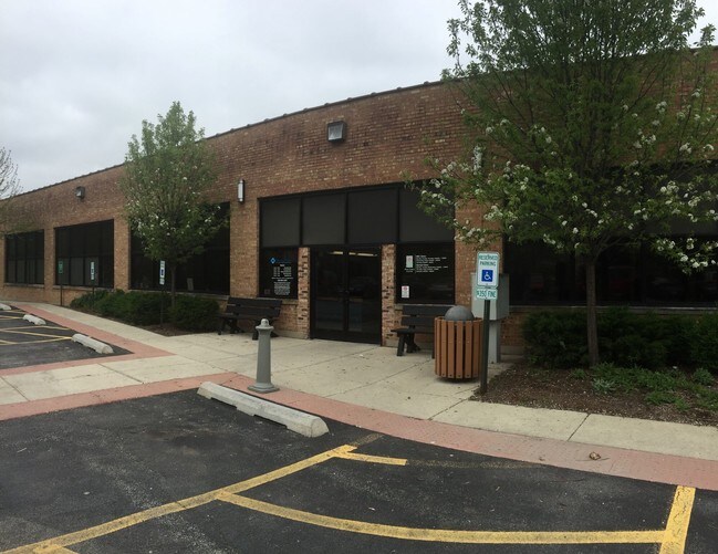
Property Record
620 Wing St, Elgin, IL 60123

Property Detail
620 Wing St
Chicago-Naperville-Elgin, IL-IN
SEARS ADDN NORTH 72.5 FT OF LOT 32
06-11-380-006
Kane
Taxexempt
Illinois
B and X Area of moderate flood hazard, usually the area between the limits of the 100-year and 500-year floods.
32
0
0.91 AC
2024
Far Northwest
854600
Chicago
NEARBY LISTINGS FOR SALE OR LEASE
DEMOGRAPHICS near 620 Wing St
1 mile
3 mile
5 mile
2025 Total Population
17,188
95,839
184,476
2030 Population
17,384
96,535
186,261
Pop Growth 2025-2030
+ 1.14%
+ 0.73%
+ 0.97%
Average Age
37
38
39
2025 Total Households
6,004
32,578
63,438
HH Growth 2025-2030
+ 1.02%
+ 0.68%
+ 0.92%
Median Household Inc
$68,254
$80,614
$97,384
Avg Household Size
2.80
2.80
2.80
2025 Avg HH Vehicles
2.00
2.00
2.00
Median Home Value
$231,436
$247,519
$296,252
Median Year Built
1954
1970
1985
Nearby Places
Map Layers
Map Styles
 Street
 Aerial
Layers
 Traffic
 Biking
Places
Listings with unknown addresses are not visible on the map
- Restaurants
- Banks
- Shops
- Fitness
- Groceries
PUBLIC TRANSPORTATION
TRANSIT/SUBWAY
Elgin Station (Milwaukee District West Line - Northeast Illinois Regional Commuter Railroad (Metra))
Drive
Walk
Distance
Elgin Station (Milwaukee District West Line - Northeast Illinois Regional Commuter Railroad (Metra))
3 min
16 min
0.8 mi
COMMUTER RAIL
Elgin Station (Milwaukee District West Line - Northeast Illinois Regional Commuter Railroad (Metra))
Drive
Walk
Distance
Elgin Station (Milwaukee District West Line - Northeast Illinois Regional Commuter Railroad (Metra))
3 min
16 min
0.8 mi
National Street Station (Milwaukee District West Line - Northeast Illinois Regional Commuter Railroad (Metra))
Drive
Walk
Distance
National Street Station (Milwaukee District West Line - Northeast Illinois Regional Commuter Railroad (Metra))
6 min
1.7 mi
AIRPORT
Chicago O'Hare International
Drive
Walk
Distance
Chicago O'Hare International
52 min
28.8 mi
Chicago Midway International
Drive
Walk
Distance
Chicago Midway International
68 min
45.4 mi
SALE & LEASE HISTORY
LISTING DATE
SALE/LEASE

Sep 24, 2016
For Lease
Jan 23, 2019
For Lease
Nearby Properties
Address
Land Use
TOTAL SIZE
Lot Size
Zoning
Address
Land Use
TOTAL SIZE
Lot Size
Zoning
551,248 SF
28.94 AC
Address
Land Use
TOTAL SIZE
Lot Size
Zoning
61.92 AC
Address
Land Use
TOTAL SIZE
Lot Size
Zoning
23.54 AC
Address
Land Use
TOTAL SIZE
Lot Size
Zoning
27.33 AC
Address
Land Use
TOTAL SIZE
Lot Size
Zoning
108.60 AC
Address
Land Use
TOTAL SIZE
Lot Size
Zoning
51,091 SF
3.52 AC
Address
Land Use
TOTAL SIZE
Lot Size
Zoning
20.93 AC
Address
Land Use
TOTAL SIZE
Lot Size
Zoning
431,318 SF
20 AC
Address
Land Use
TOTAL SIZE
Lot Size
Zoning
Address
Land Use
TOTAL SIZE
Lot Size
Zoning
Address
Land Use
TOTAL SIZE
Lot Size
Zoning
Address
Land Use
TOTAL SIZE
Lot Size
Zoning
99,800 SF
0.53 AC
Address
Land Use
TOTAL SIZE
Lot Size
Zoning
238,115 SF
21.61 AC
Address
Land Use
TOTAL SIZE
Lot Size
Zoning
35,808 SF
11.40 AC
Address
Land Use
TOTAL SIZE
Lot Size
Zoning
8,012 SF
6.56 AC
Address
Land Use
TOTAL SIZE
Lot Size
Zoning
7,254 SF
1.98 AC
Address
Land Use
TOTAL SIZE
Lot Size
Zoning
76,884 SF
2.87 AC
Address
Land Use
TOTAL SIZE
Lot Size
Zoning
Address
Land Use
TOTAL SIZE
Lot Size
Zoning
176,799 SF
10 AC
Address
Land Use
TOTAL SIZE
Lot Size
Zoning
193,288 SF
16.24 AC
Address
Land Use
TOTAL SIZE
Lot Size
Zoning
38,550 SF
0.60 AC
Address
Land Use
TOTAL SIZE
Lot Size
Zoning
93,341 SF
3.67 AC
Address
Land Use
TOTAL SIZE
Lot Size
Zoning
99,903 SF
6.49 AC
Address
Land Use
TOTAL SIZE
Lot Size
Zoning
10.03 AC
Address
Land Use
TOTAL SIZE
Lot Size
Zoning
142,044 SF
14.98 AC
Address
Land Use
TOTAL SIZE
Lot Size
Zoning
179,857 SF
4.60 AC
Address
Land Use
TOTAL SIZE
Lot Size
Zoning
130,050 SF
12.64 AC
Address
Land Use
TOTAL SIZE
Lot Size
Zoning
Address
Land Use
TOTAL SIZE
Lot Size
Zoning
154,483 SF
10 AC
Address
Land Use
TOTAL SIZE
Lot Size
Zoning
The World's #1 Commercial Real Estate Marketplace
Connect with us
© 2026 CoStar Group
The information above has been obtained from sources believed reliable. While we do not doubt its accuracy we have not verified it and make no guarantee, warranty or representation about it. It is your responsibility to independently confirm its accuracy and completeness. Any projections, opinions, assumptions, or estimates used are for example only and do not represent the current or future performance of the property. The value of this transaction to you depends on tax and other factors which should be evaluated by your tax, financial, and legal advisors. You and your advisors should conduct a careful, independent investigation of the property to determine to your satisfaction the suitability of the property for your needs.