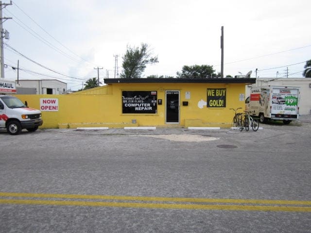
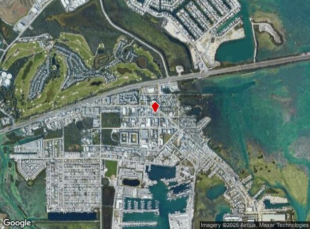
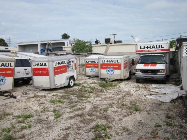
Property Record
6200 2Nd St, Key West, FL 33040
NEARBY LISTINGS FOR SALE OR LEASE
Property Detail
6200 2Nd St
Key West-Key Largo, FL
Maloney Subd
00124880-000000
BK35 SLY 69 FT LT 11 AND 12 MALONEY SUB SUBDIVISION PB1-55 STOCK ISLAND OR382-1000/01 OR651-848 OR1086-455 OR1317-1537/38 OR1317-1539/41 OR1318-2437/39 OR1538-782/84 OR2471-596/98 OR2483-1262/64S/D OR2499-718/19S/D OR2611-1675 OR2630-486 OR2630-487 O
Storemultistory
Monroe
AE
Florida
12087C1528K
11,12
2023
0.16 AC
2023
Key West
971800
Other Market Areas
1,330 SF
DEMOGRAPHICS near 6200 2Nd St
1 Mile
3 Mile
5 Mile
2024 Total Population
5,373
17,135
28,256
2029 Population
5,020
16,320
26,936
Pop Growth 2024-2029
(6.57%)
(4.76%)
(4.67%)
Average Age
41
41
43
2024 Total Households
1,933
6,519
11,834
HH Growth 2024-2029
(6.88%)
(5.08%)
(4.88%)
Median Household Inc
$67,945
$70,810
$72,213
Avg Household Size
2.50
2.40
2.30
2024 Avg HH Vehicles
2.00
2.00
1.00
Median Home Value
$679,428
$671,022
$713,258
Median Year Built
1982
1978
1972
Nearby Places
Map Layers
Map Styles
 Street
 Aerial
- Restaurants
- Banks
- Shops
- Fitness
- Groceries
PUBLIC TRANSPORTATION
AIRPORT
Key West International
DRIVE
WALK
Distance
Key West International
10 min
3.8 mi
Freight Ports
Port of Miami
DRIVE
WALK
Distance
Port of Miami
240 min
161.4 mi
Nearby Properties
Address
Land Use
TOTAL SIZE
Lot Size
Zoning
Address
Land Use
TOTAL SIZE
Lot Size
Zoning
98,815 SF
341.08 AC
M
Address
Land Use
TOTAL SIZE
Lot Size
Zoning
309.74 AC
MF
Address
Land Use
TOTAL SIZE
Lot Size
Zoning
105.78 AC
COW
Address
Land Use
TOTAL SIZE
Lot Size
Zoning
58,091 SF
4.87 AC
CT
Address
Land Use
TOTAL SIZE
Lot Size
Zoning
300,215 SF
13.94 AC
PS
Address
Land Use
TOTAL SIZE
Lot Size
Zoning
225,221 SF
17.11 AC
HDR
Address
Land Use
TOTAL SIZE
Lot Size
Zoning
115,501 SF
96.47 AC
Address
Land Use
TOTAL SIZE
Lot Size
Zoning
126,563 SF
6.07 AC
HDR
Address
Land Use
TOTAL SIZE
Lot Size
Zoning
109,118 SF
7.80 AC
MU
Address
Land Use
TOTAL SIZE
Lot Size
Zoning
219,839 SF
7.52 AC
URM
Address
Land Use
TOTAL SIZE
Lot Size
Zoning
228,039 SF
18.85 AC
PS
Address
Land Use
TOTAL SIZE
Lot Size
Zoning
147,707 SF
6.24 AC
MDR
Address
Land Use
TOTAL SIZE
Lot Size
Zoning
90,585 SF
2 AC
CG
Address
Land Use
TOTAL SIZE
Lot Size
Zoning
222,433 SF
25.69 AC
PS
Address
Land Use
TOTAL SIZE
Lot Size
Zoning
232,414 SF
17.63 AC
CG
Address
Land Use
TOTAL SIZE
Lot Size
Zoning
2,594 SF
22.38 AC
MDR
Address
Land Use
TOTAL SIZE
Lot Size
Zoning
189,418 SF
17.41 AC
CG
Address
Land Use
TOTAL SIZE
Lot Size
Zoning
178,252 SF
15.21 AC
CG
Address
Land Use
TOTAL SIZE
Lot Size
Zoning
85,189 SF
1.91 AC
Address
Land Use
TOTAL SIZE
Lot Size
Zoning
64,746 SF
3.83 AC
CG
Address
Land Use
TOTAL SIZE
Lot Size
Zoning
68,168 SF
3.06 AC
CG
Address
Land Use
TOTAL SIZE
Lot Size
Zoning
60,305 SF
5.10 AC
CT
Address
Land Use
TOTAL SIZE
Lot Size
Zoning
254,529 SF
21.61 AC
M
Address
Land Use
TOTAL SIZE
Lot Size
Zoning
33,925 SF
3.14 AC
CG
Address
Land Use
TOTAL SIZE
Lot Size
Zoning
60,580 SF
3.78 AC
MDR
Address
Land Use
TOTAL SIZE
Lot Size
Zoning
293,187 SF
168.13 AC
A
Address
Land Use
TOTAL SIZE
Lot Size
Zoning
56,115 SF
3.31 AC
CG
Address
Land Use
TOTAL SIZE
Lot Size
Zoning
43,942 SF
34.27 AC
PS
Address
Land Use
TOTAL SIZE
Lot Size
Zoning
43,019 SF
2.03 AC
CG
Address
Land Use
TOTAL SIZE
Lot Size
Zoning
63,357 SF
9.21 AC
PS
The World's #1 Commercial Real Estate Marketplace
Connect with us
© 2026 CoStar Group
The information above has been obtained from sources believed reliable. While we do not doubt its accuracy we have not verified it and make no guarantee, warranty or representation about it. It is your responsibility to independently confirm its accuracy and completeness. Any projections, opinions, assumptions, or estimates used are for example only and do not represent the current or future performance of the property. The value of this transaction to you depends on tax and other factors which should be evaluated by your tax, financial, and legal advisors. You and your advisors should conduct a careful, independent investigation of the property to determine to your satisfaction the suitability of the property for your needs.