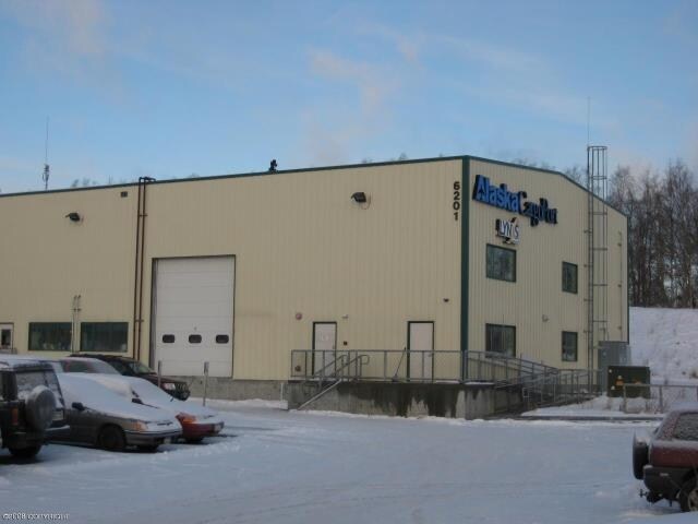
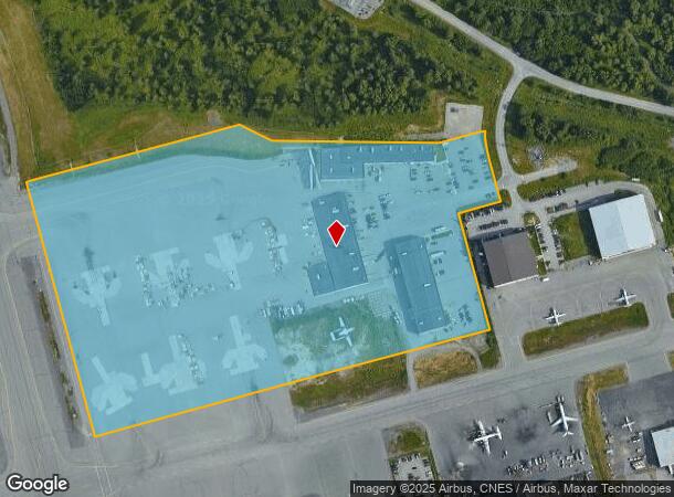
Property Record
6200 Boeing Ave, Anchorage, AK 99502
NEARBY LISTINGS FOR SALE OR LEASE
Property Detail
6200 Boeing Ave
Anchorage, AK
Intl Arpt
01047101001
ADA 30816 INTL ARPT BLK 27 LT 1D
Aircraft
Anchorage
X
Alaska
0200050710D
1d
2024
28.06 AC
2025
Spenard-10
002301
Anchorage
45,861 SF
DEMOGRAPHICS near 6200 Boeing Ave
1 Mile
3 Mile
5 Mile
2024 Total Population
0
16,560
76,559
2029 Population
0
16,311
75,611
Pop Growth 2024-2029
0.00%
(1.50%)
(1.24%)
Average Age
0
40
39
2024 Total Households
0
6,969
31,930
HH Growth 2024-2029
0.00%
(1.58%)
(1.27%)
Median Household Inc
$0
$92,150
$83,181
Avg Household Size
.00
2.30
2.30
2024 Avg HH Vehicles
.00
2.00
2.00
Median Home Value
$0
$356,249
$357,871
Median Year Built
0
1976
1977
Nearby Places
Map Layers
Map Styles
 Street
 Aerial
- Restaurants
- Banks
- Shops
- Fitness
- Groceries
PUBLIC TRANSPORTATION
AIRPORT
Ted Stevens Anchorage International
DRIVE
WALK
Distance
Ted Stevens Anchorage International
9 min
3.3 mi
Merrill Field
DRIVE
WALK
Distance
Merrill Field
19 min
7.5 mi
Freight Ports
Port of Anchorage
DRIVE
WALK
Distance
Port of Anchorage
20 min
7.2 mi
Nearby Properties
Address
Land Use
TOTAL SIZE
Lot Size
Zoning
Address
Land Use
TOTAL SIZE
Lot Size
Zoning
91,034 SF
63.70 AC
TR
Address
Land Use
TOTAL SIZE
Lot Size
Zoning
195,079 SF
44.79 AC
PLI
Address
Land Use
TOTAL SIZE
Lot Size
Zoning
191.79 AC
PLI
Address
Land Use
TOTAL SIZE
Lot Size
Zoning
65,314 SF
111.15 AC
PLI
Address
Land Use
TOTAL SIZE
Lot Size
Zoning
134.97 AC
TR
Address
Land Use
TOTAL SIZE
Lot Size
Zoning
341,267 SF
5.51 AC
TR
Address
Land Use
TOTAL SIZE
Lot Size
Zoning
79.26 AC
PLI
Address
Land Use
TOTAL SIZE
Lot Size
Zoning
103,442 SF
3.50 AC
B3
Address
Land Use
TOTAL SIZE
Lot Size
Zoning
3,813 SF
31.29 AC
PLIP
Address
Land Use
TOTAL SIZE
Lot Size
Zoning
97,524 SF
6.85 AC
TR
Address
Land Use
TOTAL SIZE
Lot Size
Zoning
Address
Land Use
TOTAL SIZE
Lot Size
Zoning
54,285 SF
3.47 AC
B3SL
Address
Land Use
TOTAL SIZE
Lot Size
Zoning
73,200 SF
11.19 AC
TR
Address
Land Use
TOTAL SIZE
Lot Size
Zoning
41,406 SF
4.20 AC
B3SL
Address
Land Use
TOTAL SIZE
Lot Size
Zoning
32,764 SF
2.24 AC
R4
Address
Land Use
TOTAL SIZE
Lot Size
Zoning
41,756 SF
6.78 AC
I1
Address
Land Use
TOTAL SIZE
Lot Size
Zoning
79,714 SF
10.66 AC
TR
Address
Land Use
TOTAL SIZE
Lot Size
Zoning
15,600 SF
3.44 AC
R3
Address
Land Use
TOTAL SIZE
Lot Size
Zoning
273,094 SF
22.69 AC
TR
Address
Land Use
TOTAL SIZE
Lot Size
Zoning
92,766 SF
7.61 AC
B3
Address
Land Use
TOTAL SIZE
Lot Size
Zoning
70,350 SF
8 AC
PLI
Address
Land Use
TOTAL SIZE
Lot Size
Zoning
63,164 SF
6.83 AC
RO
Address
Land Use
TOTAL SIZE
Lot Size
Zoning
10,680 SF
8.72 AC
PLI
Address
Land Use
TOTAL SIZE
Lot Size
Zoning
160 AC
PLIP
Address
Land Use
TOTAL SIZE
Lot Size
Zoning
14,386 SF
10 AC
R2A
Address
Land Use
TOTAL SIZE
Lot Size
Zoning
21,038 SF
2 AC
B3
Address
Land Use
TOTAL SIZE
Lot Size
Zoning
17,774 SF
5.57 AC
TR
Address
Land Use
TOTAL SIZE
Lot Size
Zoning
59,740 SF
7.41 AC
I1
Address
Land Use
TOTAL SIZE
Lot Size
Zoning
53,368 SF
34.81 AC
TR
Address
Land Use
TOTAL SIZE
Lot Size
Zoning
56,643 SF
15.07 AC
PLI
The World's #1 Commercial Real Estate Marketplace
Connect with us
© 2026 CoStar Group
The information above has been obtained from sources believed reliable. While we do not doubt its accuracy we have not verified it and make no guarantee, warranty or representation about it. It is your responsibility to independently confirm its accuracy and completeness. Any projections, opinions, assumptions, or estimates used are for example only and do not represent the current or future performance of the property. The value of this transaction to you depends on tax and other factors which should be evaluated by your tax, financial, and legal advisors. You and your advisors should conduct a careful, independent investigation of the property to determine to your satisfaction the suitability of the property for your needs.