Property Record
6200 Cornhusker Hwy, Lincoln, NE 68507

NEARBY LISTINGS FOR SALE OR LEASE
-
-
View all Lincoln listings for sale on LoopNet.com
Property Detail
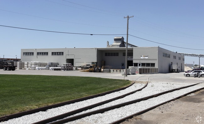
6200 Cornhusker Hwy
Lincoln, NE
6Th Principal Meridian
17-04-100-016-000
S4, T10, R7, 6TH PRINCIPAL MERIDIAN, LOTS 56,69,76,78,79 & 86 NW & LOT 95 NE & LOT 97 SW EX RD & CLEAVER BROOKS ADD LOT 1
Officebuilding
Lancaster
X
Nebraska
31109C0310F
95
2024
93.02 AC
2025
Northeast
002900
Lincoln
294,243 SF
DEMOGRAPHICS near 6200 Cornhusker Hwy
1 Mile
3 Mile
5 Mile
2024 Total Population
2,802
48,948
135,305
2029 Population
2,898
50,834
140,640
Pop Growth 2024-2029
+ 3.43%
+ 3.85%
+ 3.94%
Average Age
41
38
36
2024 Total Households
1,326
21,111
55,381
HH Growth 2024-2029
+ 3.54%
+ 4.02%
+ 4.11%
Median Household Inc
$42,981
$56,748
$56,488
Avg Household Size
2.10
2.20
2.30
2024 Avg HH Vehicles
2.00
2.00
2.00
Median Home Value
$134,958
$178,469
$192,618
Median Year Built
1950
1977
1977
Nearby Places
Map Layers
Map Styles
 Street
 Aerial
- Restaurants
- Banks
- Shops
- Fitness
- Groceries
PUBLIC TRANSPORTATION
COMMUTER RAIL
DRIVE
WALK
Distance
11 min
5.6 mi
AIRPORT
Lincoln
DRIVE
WALK
Distance
Lincoln
15 min
7.6 mi
Nearby Properties
Address
Land Use
TOTAL SIZE
Lot Size
Zoning
Address
Land Use
TOTAL SIZE
Lot Size
Zoning
382,244 SF
44.25 AC
R6
Address
Land Use
TOTAL SIZE
Lot Size
Zoning
293,488 SF
570.28 AC
Address
Land Use
TOTAL SIZE
Lot Size
Zoning
48,088 SF
28.06 AC
R5
Address
Land Use
TOTAL SIZE
Lot Size
Zoning
32,110 SF
14.60 AC
R5
Address
Land Use
TOTAL SIZE
Lot Size
Zoning
27,171 SF
14.68 AC
NULL
Address
Land Use
TOTAL SIZE
Lot Size
Zoning
430,949 SF
41.47 AC
P
Address
Land Use
TOTAL SIZE
Lot Size
Zoning
65,064 SF
1.39 AC
R6
Address
Land Use
TOTAL SIZE
Lot Size
Zoning
102,739 SF
4.24 AC
B2
Address
Land Use
TOTAL SIZE
Lot Size
Zoning
41,456 SF
4.95 AC
B2
Address
Land Use
TOTAL SIZE
Lot Size
Zoning
8,824 SF
12.33 AC
R5
Address
Land Use
TOTAL SIZE
Lot Size
Zoning
65,967 SF
11.65 AC
NULL
Address
Land Use
TOTAL SIZE
Lot Size
Zoning
10,688 SF
237.77 AC
P
Address
Land Use
TOTAL SIZE
Lot Size
Zoning
63,914 SF
12.22 AC
R5
Address
Land Use
TOTAL SIZE
Lot Size
Zoning
46,906 SF
2.88 AC
Address
Land Use
TOTAL SIZE
Lot Size
Zoning
51,080 SF
12.42 AC
Address
Land Use
TOTAL SIZE
Lot Size
Zoning
38,769 SF
11.81 AC
NULL
Address
Land Use
TOTAL SIZE
Lot Size
Zoning
92,054 SF
6.22 AC
R5
Address
Land Use
TOTAL SIZE
Lot Size
Zoning
69,760 SF
1.81 AC
Address
Land Use
TOTAL SIZE
Lot Size
Zoning
30,608 SF
25.92 AC
R4
Address
Land Use
TOTAL SIZE
Lot Size
Zoning
41,172 SF
5.16 AC
P
Address
Land Use
TOTAL SIZE
Lot Size
Zoning
360,422 SF
23.53 AC
B5
Address
Land Use
TOTAL SIZE
Lot Size
Zoning
69,652 SF
3.10 AC
B3
Address
Land Use
TOTAL SIZE
Lot Size
Zoning
36,041 SF
5.43 AC
R5
Address
Land Use
TOTAL SIZE
Lot Size
Zoning
1,500 SF
230.35 AC
P
Address
Land Use
TOTAL SIZE
Lot Size
Zoning
17,312 SF
177.49 AC
AG
Address
Land Use
TOTAL SIZE
Lot Size
Zoning
59,073 SF
18.66 AC
R4
Address
Land Use
TOTAL SIZE
Lot Size
Zoning
154.12 AC
P
Address
Land Use
TOTAL SIZE
Lot Size
Zoning
759,282 SF
40.67 AC
I1
Address
Land Use
TOTAL SIZE
Lot Size
Zoning
141.81 AC
P
Address
Land Use
TOTAL SIZE
Lot Size
Zoning
37,044 SF
5.49 AC
R3
The World's #1 Commercial Real Estate Marketplace
Connect with us
© 2026 CoStar Group
The information above has been obtained from sources believed reliable. While we do not doubt its accuracy we have not verified it and make no guarantee, warranty or representation about it. It is your responsibility to independently confirm its accuracy and completeness. Any projections, opinions, assumptions, or estimates used are for example only and do not represent the current or future performance of the property. The value of this transaction to you depends on tax and other factors which should be evaluated by your tax, financial, and legal advisors. You and your advisors should conduct a careful, independent investigation of the property to determine to your satisfaction the suitability of the property for your needs.