Property Record
6200 Enright Ave, Saint Louis, MO 63130


NEARBY LISTINGS FOR SALE OR LEASE
Property Detail
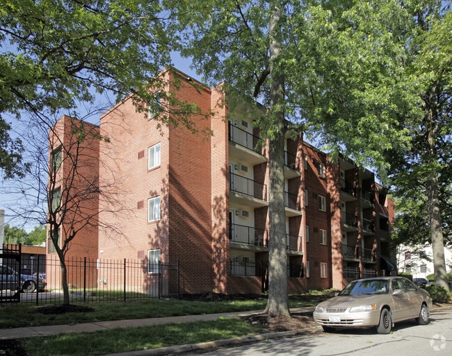
6200 Enright Ave
St. Louis, MO-IL
North Parkview Blk 1 Lots 4 Thru 9 & 25
18H-42-1604
NORTH PARKVIEW BLK 1 LOTS 4 THRU 9 & 25 THRU 44 & WALKWAY VACATED PT & BLK 6 LOTS 1 2 & 13 & LOT PTS 3 4 & 14 & VACATED ALLEY PT RESUB LOT PT 2
Apartment
St. Louis
X
Missouri
29189C0216K
1
0
2.58 AC
2025
University City
216102
St. Louis
148,683 SF
DEMOGRAPHICS near 6200 Enright Ave
1 Mile
3 Mile
5 Mile
2024 Total Population
22,485
136,647
331,190
2029 Population
22,129
134,371
323,067
Pop Growth 2024-2029
(1.58%)
(1.67%)
(2.45%)
Average Age
33
39
40
2024 Total Households
8,166
62,846
150,791
HH Growth 2024-2029
(1.63%)
(1.97%)
(2.71%)
Median Household Inc
$54,902
$57,730
$54,402
Avg Household Size
2.10
2.00
2.00
2024 Avg HH Vehicles
1.00
1.00
1.00
Median Home Value
$347,574
$250,137
$205,039
Median Year Built
1948
1948
1949
Nearby Places
Map Layers
Map Styles
 Street
 Aerial
- Restaurants
- Banks
- Shops
- Fitness
- Groceries
PUBLIC TRANSPORTATION
TRANSIT/SUBWAY
Delmar Loop (Lambert Airport Shiloh-Scott - St. Louis MetroLink (MetroLink))
DRIVE
WALK
Distance
Delmar Loop (Lambert Airport Shiloh-Scott - St. Louis MetroLink (MetroLink))
3 min
13 min
0.7 mi
Skinker (Shrewsbury-Lansdowne I-44 Emerson Park - St. Louis MetroLink (MetroLink))
DRIVE
WALK
Distance
Skinker (Shrewsbury-Lansdowne I-44 Emerson Park - St. Louis MetroLink (MetroLink))
3 min
15 min
0.8 mi
University City-Big Bend (Shrewsbury-Lansdowne I-44 Emerson Park - St. Louis MetroLink (MetroLink))
DRIVE
WALK
Distance
University City-Big Bend (Shrewsbury-Lansdowne I-44 Emerson Park - St. Louis MetroLink (MetroLink))
3 min
18 min
0.9 mi
COMMUTER RAIL
Delmar Loop (Lambert Airport Shiloh-Scott - St. Louis MetroLink (MetroLink))
DRIVE
WALK
Distance
Delmar Loop (Lambert Airport Shiloh-Scott - St. Louis MetroLink (MetroLink))
2 min
13 min
0.7 mi
Skinker (Shrewsbury-Lansdowne I-44 Emerson Park - St. Louis MetroLink (MetroLink))
DRIVE
WALK
Distance
Skinker (Shrewsbury-Lansdowne I-44 Emerson Park - St. Louis MetroLink (MetroLink))
3 min
15 min
0.8 mi
AIRPORT
St Louis Lambert International
DRIVE
WALK
Distance
St Louis Lambert International
16 min
8.7 mi
Scott AFB/Midamerica St Louis
DRIVE
WALK
Distance
Scott AFB/Midamerica St Louis
51 min
33.4 mi
Nearby Properties
Address
Land Use
TOTAL SIZE
Lot Size
Zoning
Address
Land Use
TOTAL SIZE
Lot Size
Zoning
684,846 SF
90.65 AC
R6
Address
Land Use
TOTAL SIZE
Lot Size
Zoning
Address
Land Use
TOTAL SIZE
Lot Size
Zoning
136.92 AC
AI
Address
Land Use
TOTAL SIZE
Lot Size
Zoning
558,158 SF
45.66 AC
14R-2
Address
Land Use
TOTAL SIZE
Lot Size
Zoning
833,982 SF
18.70 AC
GB
Address
Land Use
TOTAL SIZE
Lot Size
Zoning
5,898 SF
21.62 AC
R2
Address
Land Use
TOTAL SIZE
Lot Size
Zoning
152.07 AC
L
Address
Land Use
TOTAL SIZE
Lot Size
Zoning
52,556 SF
68.80 AC
14R-2
Address
Land Use
TOTAL SIZE
Lot Size
Zoning
516,414 SF
2.61 AC
14C-2
Address
Land Use
TOTAL SIZE
Lot Size
Zoning
1,361,485 SF
5.45 AC
E
Address
Land Use
TOTAL SIZE
Lot Size
Zoning
361,357 SF
2.99 AC
14HDC
Address
Land Use
TOTAL SIZE
Lot Size
Zoning
238,035 SF
3.23 AC
14HDC
Address
Land Use
TOTAL SIZE
Lot Size
Zoning
5,551 SF
0.72 AC
14HDC
Address
Land Use
TOTAL SIZE
Lot Size
Zoning
501,837 SF
21.52 AC
14PUD
Address
Land Use
TOTAL SIZE
Lot Size
Zoning
390,010 SF
13.25 AC
R6
Address
Land Use
TOTAL SIZE
Lot Size
Zoning
361,605 SF
1.75 AC
14HDC
Address
Land Use
TOTAL SIZE
Lot Size
Zoning
385,676 SF
3.04 AC
C4
Address
Land Use
TOTAL SIZE
Lot Size
Zoning
7,780 SF
15.61 AC
14R-2
Address
Land Use
TOTAL SIZE
Lot Size
Zoning
354,868 SF
2.04 AC
14HDC
Address
Land Use
TOTAL SIZE
Lot Size
Zoning
7.94 AC
D
Address
Land Use
TOTAL SIZE
Lot Size
Zoning
272,933 SF
0.82 AC
14PUD
Address
Land Use
TOTAL SIZE
Lot Size
Zoning
311,264 SF
1.40 AC
14HDC
Address
Land Use
TOTAL SIZE
Lot Size
Zoning
476,403 SF
1.40 AC
14HDC
Address
Land Use
TOTAL SIZE
Lot Size
Zoning
277,568 SF
0.68 AC
14HDC
Address
Land Use
TOTAL SIZE
Lot Size
Zoning
330,896 SF
2.68 AC
14HDC
Address
Land Use
TOTAL SIZE
Lot Size
Zoning
272,940 SF
0.87 AC
14PUD
Address
Land Use
TOTAL SIZE
Lot Size
Zoning
1.33 AC
C4
Address
Land Use
TOTAL SIZE
Lot Size
Zoning
316,517 SF
3.28 AC
14C-1
Address
Land Use
TOTAL SIZE
Lot Size
Zoning
33,004 SF
1.53 AC
14HDC
Address
Land Use
TOTAL SIZE
Lot Size
Zoning
6.05 AC
J
The World's #1 Commercial Real Estate Marketplace
Connect with us
© 2025 CoStar Group
The information above has been obtained from sources believed reliable. While we do not doubt its accuracy we have not verified it and make no guarantee, warranty or representation about it. It is your responsibility to independently confirm its accuracy and completeness. Any projections, opinions, assumptions, or estimates used are for example only and do not represent the current or future performance of the property. The value of this transaction to you depends on tax and other factors which should be evaluated by your tax, financial, and legal advisors. You and your advisors should conduct a careful, independent investigation of the property to determine to your satisfaction the suitability of the property for your needs.