Property Record
6200 King Rd, Marine City, MI 48039


NEARBY LISTINGS FOR SALE OR LEASE
-
-
View all Marine City listings for lease on LoopNet.com
Property Detail
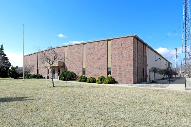
6200 King Rd
02-002-2010-000
BEG S 3D 28M W 1057.22' FROM NE SEC COR SEC 2, TH N 87D 31M W 510.95', TH S 3D 28M W 298', TH S 87D 31M E 510.95', TH N 3D 28M E 298' TO POB CONT 3.5 A T3N R16E SEC 2
Manufacturinglight
St. Clair
X
Michigan
26147C0510D
3.50 AC
2025
St Clair & Lapeer Counties
2025
Detroit
644000
Detroit-Warren-Dearborn, MI
23,640 SF
DEMOGRAPHICS near 6200 King Rd
1 Mile
3 Mile
5 Mile
2024 Total Population
3,009
8,405
11,887
2029 Population
3,015
8,407
11,862
Pop Growth 2024-2029
+ 0.20%
+ 0.02%
(0.21%)
Average Age
44
44
45
2024 Total Households
1,340
3,614
4,991
HH Growth 2024-2029
0.00%
(0.03%)
(0.22%)
Median Household Inc
$59,711
$58,073
$62,061
Avg Household Size
2.20
2.30
2.30
2024 Avg HH Vehicles
2.00
2.00
2.00
Median Home Value
$152,384
$175,794
$203,383
Median Year Built
1953
1967
1971
Nearby Places
Map Layers
Map Styles
 Street
 Aerial
- Restaurants
- Banks
- Shops
- Fitness
- Groceries
SALE & LEASE HISTORY
LISTING DATE
SALE/LEASE

Mar 29, 2018
For Sale
Aug 09, 2018
For Lease
Nearby Properties
Address
Land Use
TOTAL SIZE
Lot Size
Zoning
Address
Land Use
TOTAL SIZE
Lot Size
Zoning
10.27 AC
Address
Land Use
TOTAL SIZE
Lot Size
Zoning
75,055 SF
10.27 AC
Address
Land Use
TOTAL SIZE
Lot Size
Zoning
84,119 SF
5.19 AC
Address
Land Use
TOTAL SIZE
Lot Size
Zoning
5,657 SF
53.89 AC
A-1 AG
Address
Land Use
TOTAL SIZE
Lot Size
Zoning
28,119 SF
Address
Land Use
TOTAL SIZE
Lot Size
Zoning
74,182 SF
4.04 AC
Address
Land Use
TOTAL SIZE
Lot Size
Zoning
51,000 SF
6 AC
Address
Land Use
TOTAL SIZE
Lot Size
Zoning
51,520 SF
5.73 AC
Address
Land Use
TOTAL SIZE
Lot Size
Zoning
38,020 SF
4.88 AC
R1
Address
Land Use
TOTAL SIZE
Lot Size
Zoning
54,377 SF
5.29 AC
Address
Land Use
TOTAL SIZE
Lot Size
Zoning
2,069 SF
291.09 AC
R-1 RE
Address
Land Use
TOTAL SIZE
Lot Size
Zoning
12,042 SF
1.05 AC
R1
Address
Land Use
TOTAL SIZE
Lot Size
Zoning
39,950 SF
2.46 AC
Address
Land Use
TOTAL SIZE
Lot Size
Zoning
4,026 SF
0.23 AC
R1
Address
Land Use
TOTAL SIZE
Lot Size
Zoning
23,920 SF
2.75 AC
Address
Land Use
TOTAL SIZE
Lot Size
Zoning
121.53 AC
R-3
Address
Land Use
TOTAL SIZE
Lot Size
Zoning
12,835 SF
4.26 AC
Address
Land Use
TOTAL SIZE
Lot Size
Zoning
38,558 SF
1.94 AC
Address
Land Use
TOTAL SIZE
Lot Size
Zoning
27,216 SF
2.83 AC
Address
Land Use
TOTAL SIZE
Lot Size
Zoning
10,500 SF
2.13 AC
RM-2
Address
Land Use
TOTAL SIZE
Lot Size
Zoning
10,644 SF
1.72 AC
Address
Land Use
TOTAL SIZE
Lot Size
Zoning
1,000 SF
4.51 AC
R1
Address
Land Use
TOTAL SIZE
Lot Size
Zoning
33,075 SF
2.60 AC
Address
Land Use
TOTAL SIZE
Lot Size
Zoning
Address
Land Use
TOTAL SIZE
Lot Size
Zoning
3,393 SF
108.15 AC
MHP MOB
Address
Land Use
TOTAL SIZE
Lot Size
Zoning
29,020 SF
3.67 AC
B-2
Address
Land Use
TOTAL SIZE
Lot Size
Zoning
1,648 SF
35.41 AC
A-1 AG
Address
Land Use
TOTAL SIZE
Lot Size
Zoning
33,752 SF
5.32 AC
Address
Land Use
TOTAL SIZE
Lot Size
Zoning
1,200 SF
120 AC
AG
Address
Land Use
TOTAL SIZE
Lot Size
Zoning
31,867 SF
3.27 AC
R-2
The World's #1 Commercial Real Estate Marketplace
Connect with us
© 2025 CoStar Group
The information above has been obtained from sources believed reliable. While we do not doubt its accuracy we have not verified it and make no guarantee, warranty or representation about it. It is your responsibility to independently confirm its accuracy and completeness. Any projections, opinions, assumptions, or estimates used are for example only and do not represent the current or future performance of the property. The value of this transaction to you depends on tax and other factors which should be evaluated by your tax, financial, and legal advisors. You and your advisors should conduct a careful, independent investigation of the property to determine to your satisfaction the suitability of the property for your needs.