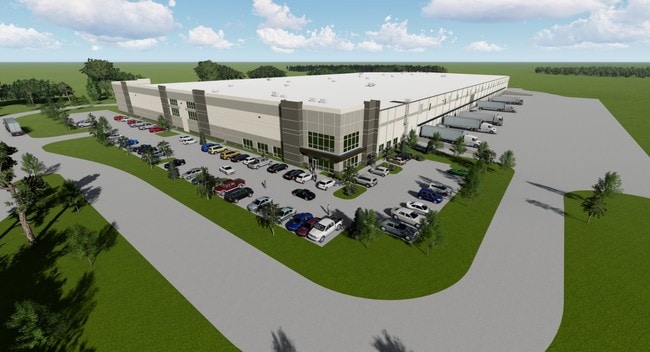
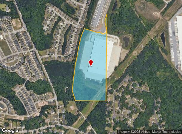
Property Record
6200 Mimms Ct, Atlanta, GA 30344
NEARBY LISTINGS FOR SALE OR LEASE
Property Detail
6200 Mimms Ct
09F-3700-0155-585-5
Fulton
Warehouse
Georgia
2023
23.20 AC
2025
Airport/North Clayton
011306
Atlanta
327,250 SF
Atlanta-Sandy Springs-Roswell, GA
DEMOGRAPHICS near 6200 Mimms Ct
1 Mile
3 Mile
5 Mile
2024 Total Population
6,194
52,957
151,942
2029 Population
6,421
55,122
156,776
Pop Growth 2024-2029
+ 3.66%
+ 4.09%
+ 3.18%
Average Age
35
36
38
2024 Total Households
2,359
21,094
59,590
HH Growth 2024-2029
+ 3.73%
+ 3.96%
+ 3.17%
Median Household Inc
$44,999
$56,143
$57,193
Avg Household Size
2.60
2.50
2.50
2024 Avg HH Vehicles
2.00
2.00
2.00
Median Home Value
$168,129
$203,497
$210,237
Median Year Built
1976
1991
1985
Nearby Places
Map Layers
Map Styles
 Street
 Aerial
- Restaurants
- Banks
- Shops
- Fitness
- Groceries
PUBLIC TRANSPORTATION
AIRPORT
Hartsfield - Jackson Atlanta International
DRIVE
WALK
Distance
Hartsfield - Jackson Atlanta International
18 min
9.7 mi
Freight Ports
Georgia Ports - Savannah
DRIVE
WALK
Distance
Georgia Ports - Savannah
280 min
247.0 mi
SALE & LEASE HISTORY
LISTING DATE
SALE/LEASE

Oct 03, 2019
For Lease
Feb 24, 2020
For Lease
Nearby Properties
Address
Land Use
TOTAL SIZE
Lot Size
Zoning
Address
Land Use
TOTAL SIZE
Lot Size
Zoning
2,666 SF
46.88 AC
BP
Address
Land Use
TOTAL SIZE
Lot Size
Zoning
2,666 SF
0.43 AC
Address
Land Use
TOTAL SIZE
Lot Size
Zoning
2,666 SF
0.43 AC
Address
Land Use
TOTAL SIZE
Lot Size
Zoning
2,666 SF
0.43 AC
Address
Land Use
TOTAL SIZE
Lot Size
Zoning
2,666 SF
0.43 AC
Address
Land Use
TOTAL SIZE
Lot Size
Zoning
2,666 SF
0.43 AC
Address
Land Use
TOTAL SIZE
Lot Size
Zoning
2,666 SF
0.43 AC
Address
Land Use
TOTAL SIZE
Lot Size
Zoning
2,666 SF
0.43 AC
Address
Land Use
TOTAL SIZE
Lot Size
Zoning
2,666 SF
0.43 AC
Address
Land Use
TOTAL SIZE
Lot Size
Zoning
2,666 SF
0.43 AC
Address
Land Use
TOTAL SIZE
Lot Size
Zoning
2,666 SF
0.43 AC
Address
Land Use
TOTAL SIZE
Lot Size
Zoning
929,571 SF
65.66 AC
M1
Address
Land Use
TOTAL SIZE
Lot Size
Zoning
2,329,350 SF
32.55 AC
A
Address
Land Use
TOTAL SIZE
Lot Size
Zoning
196,294 SF
0.49 AC
R1
Address
Land Use
TOTAL SIZE
Lot Size
Zoning
356,458 SF
18.72 AC
PDMU
Address
Land Use
TOTAL SIZE
Lot Size
Zoning
6,402,340 SF
22.62 AC
MF
Address
Land Use
TOTAL SIZE
Lot Size
Zoning
4,455,803 SF
16.39 AC
C2
Address
Land Use
TOTAL SIZE
Lot Size
Zoning
6,069,632 SF
26.42 AC
R4
Address
Land Use
TOTAL SIZE
Lot Size
Zoning
1,231,833 SF
15.51 AC
C2
Address
Land Use
TOTAL SIZE
Lot Size
Zoning
330,838 SF
13.71 AC
PDMU
Address
Land Use
TOTAL SIZE
Lot Size
Zoning
4,381,104 SF
26.70 AC
AG1
Address
Land Use
TOTAL SIZE
Lot Size
Zoning
235,301 SF
27.20 AC
C2MC
Address
Land Use
TOTAL SIZE
Lot Size
Zoning
32,000 SF
8.86 AC
C
Address
Land Use
TOTAL SIZE
Lot Size
Zoning
920,396 SF
62.40 AC
R3
Address
Land Use
TOTAL SIZE
Lot Size
Zoning
997,011 SF
68.07 AC
M1
Address
Land Use
TOTAL SIZE
Lot Size
Zoning
663,520 SF
62.96 AC
C1
Address
Land Use
TOTAL SIZE
Lot Size
Zoning
213,314 SF
16.48 AC
C2C
Address
Land Use
TOTAL SIZE
Lot Size
Zoning
2,057,484 SF
14.78 AC
R4
Address
Land Use
TOTAL SIZE
Lot Size
Zoning
17,174,332 SF
39.44 AC
R3
Address
Land Use
TOTAL SIZE
Lot Size
Zoning
855,399 SF
41.79 AC
C2
The World's #1 Commercial Real Estate Marketplace
Connect with us
© 2026 CoStar Group
The information above has been obtained from sources believed reliable. While we do not doubt its accuracy we have not verified it and make no guarantee, warranty or representation about it. It is your responsibility to independently confirm its accuracy and completeness. Any projections, opinions, assumptions, or estimates used are for example only and do not represent the current or future performance of the property. The value of this transaction to you depends on tax and other factors which should be evaluated by your tax, financial, and legal advisors. You and your advisors should conduct a careful, independent investigation of the property to determine to your satisfaction the suitability of the property for your needs.