Property Record
6200 N River Pointe Dr, Garden City, ID 83714
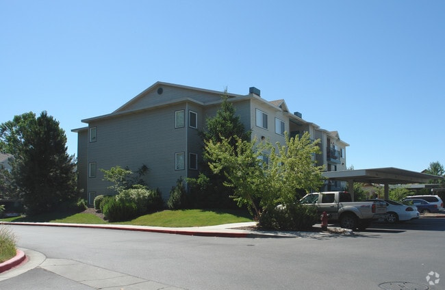
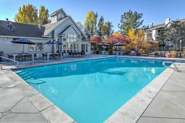

Property Detail
6200 N River Pointe Dr
R8191506539
PAR #5778 OF LOTS 22 & 23 IN SCHOOL DIST #2 STRAWBERRY GLENN SUB #5776-B
Commercialbuilding
ADA
M
Idaho
AE The base floodplain where base flood elevations are provided. AE Zones are now used on new format FIRMs instead of A1-A30 Zones.
22,23
2024
2.29 AC
2025
Northwest Section
002412
Boise City/Nampa
28,804 SF
Boise City, ID
NEARBY LISTINGS FOR SALE OR LEASE
DEMOGRAPHICS near 6200 N River Pointe Dr
1 mile
3 mile
5 mile
2025 Total Population
9,623
80,685
200,627
2030 Population
10,072
84,133
209,956
Pop Growth 2025-2030
+ 4.67%
+ 4.27%
+ 4.65%
Average Age
46
43
42
2025 Total Households
4,413
33,455
81,919
HH Growth 2025-2030
+ 5.08%
+ 4.70%
+ 5.08%
Median Household Inc
$83,695
$79,027
$85,071
Avg Household Size
2.10
2.30
2.40
2025 Avg HH Vehicles
2.00
2.00
2.00
Median Home Value
$484,095
$465,459
$512,727
Median Year Built
1994
1990
1992
Nearby Places
Map Layers
Map Styles
 Street
 Aerial
Layers
 Traffic
 Biking
Places
Listings with unknown addresses are not visible on the map
- Restaurants
- Banks
- Shops
- Fitness
- Groceries
PUBLIC TRANSPORTATION
AIRPORT
Boise Air Trml/Gowen Field
Drive
Walk
Distance
Boise Air Trml/Gowen Field
18 min
10.7 mi
Freight Ports
Port of Portland
Drive
Walk
Distance
Port of Portland
1 min
341.7 mi
Nearby Properties
Address
Land Use
TOTAL SIZE
Lot Size
Zoning
Address
Land Use
TOTAL SIZE
Lot Size
Zoning
386,225 SF
13.46 AC
C-4D/DA
Address
Land Use
TOTAL SIZE
Lot Size
Zoning
4.02 AC
C-2
Address
Land Use
TOTAL SIZE
Lot Size
Zoning
207,033 SF
10.67 AC
L-OD
Address
Land Use
TOTAL SIZE
Lot Size
Zoning
239,991 SF
8.09 AC
MU-DA
Address
Land Use
TOTAL SIZE
Lot Size
Zoning
245,000 SF
12.28 AC
R-2D
Address
Land Use
TOTAL SIZE
Lot Size
Zoning
216,950 SF
9.03 AC
R-3D
Address
Land Use
TOTAL SIZE
Lot Size
Zoning
151,285 SF
9.54 AC
R-1C
Address
Land Use
TOTAL SIZE
Lot Size
Zoning
222,379 SF
1.37 AC
M
Address
Land Use
TOTAL SIZE
Lot Size
Zoning
150,584 SF
6.77 AC
M
Address
Land Use
TOTAL SIZE
Lot Size
Zoning
7.16 AC
C-2D
Address
Land Use
TOTAL SIZE
Lot Size
Zoning
203,635 SF
4.76 AC
L-OD
Address
Land Use
TOTAL SIZE
Lot Size
Zoning
176,494 SF
10.16 AC
R-1C
Address
Land Use
TOTAL SIZE
Lot Size
Zoning
167,603 SF
6.60 AC
C-2DA
Address
Land Use
TOTAL SIZE
Lot Size
Zoning
10.32 AC
C-2D
Address
Land Use
TOTAL SIZE
Lot Size
Zoning
151,365 SF
12.03 AC
T-1D
Address
Land Use
TOTAL SIZE
Lot Size
Zoning
129,827 SF
3.08 AC
MU-DA
Address
Land Use
TOTAL SIZE
Lot Size
Zoning
124,286 SF
5 AC
R-3
Address
Land Use
TOTAL SIZE
Lot Size
Zoning
102,272 SF
7.18 AC
R-20
Address
Land Use
TOTAL SIZE
Lot Size
Zoning
92,243 SF
2.05 AC
R-3
Address
Land Use
TOTAL SIZE
Lot Size
Zoning
108,695 SF
15.52 AC
C-2D
Address
Land Use
TOTAL SIZE
Lot Size
Zoning
204,033 SF
12.88 AC
C-1
Address
Land Use
TOTAL SIZE
Lot Size
Zoning
159,839 SF
16.94 AC
C-2
Address
Land Use
TOTAL SIZE
Lot Size
Zoning
97,655 SF
7.74 AC
T-1D
Address
Land Use
TOTAL SIZE
Lot Size
Zoning
132,534 SF
1.15 AC
ZC-243
Address
Land Use
TOTAL SIZE
Lot Size
Zoning
123,324 SF
2.22 AC
R-3D
Address
Land Use
TOTAL SIZE
Lot Size
Zoning
76,684 SF
6.44 AC
R-2D
Address
Land Use
TOTAL SIZE
Lot Size
Zoning
66,322 SF
3.61 AC
T-1D
Address
Land Use
TOTAL SIZE
Lot Size
Zoning
84,070 SF
4.22 AC
R-3D
Address
Land Use
TOTAL SIZE
Lot Size
Zoning
28,776 SF
3.30 AC
C-4D
Address
Land Use
TOTAL SIZE
Lot Size
Zoning
80,722 SF
4.59 AC
C-2D
The World's #1 Commercial Real Estate Marketplace
Connect with us
© 2026 CoStar Group
The information above has been obtained from sources believed reliable. While we do not doubt its accuracy we have not verified it and make no guarantee, warranty or representation about it. It is your responsibility to independently confirm its accuracy and completeness. Any projections, opinions, assumptions, or estimates used are for example only and do not represent the current or future performance of the property. The value of this transaction to you depends on tax and other factors which should be evaluated by your tax, financial, and legal advisors. You and your advisors should conduct a careful, independent investigation of the property to determine to your satisfaction the suitability of the property for your needs.