Property Record
6201 16Th Ave Sw, Cedar Rapids, IA 52404
NEARBY LISTINGS FOR SALE OR LEASE
Property Detail
6201 16Th Ave Sw
13352-26001-00000
LANDS (LESS HWY) N 496.3 E 965.5 NW NW STR/LB 35 83 8
Commercialnec
Linn
X
Iowa
19113C0385E
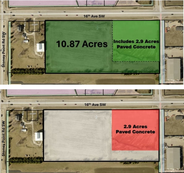
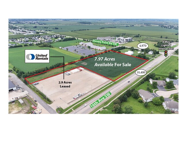
10.87 AC
2024
Iowa City/Waterloo
2025
Other Market Areas
002900
Cedar Rapids, IA
DEMOGRAPHICS near 6201 16Th Ave Sw
1 Mile
3 Mile
5 Mile
2024 Total Population
8,864
38,477
70,339
2029 Population
8,839
38,362
70,370
Pop Growth 2024-2029
(0.28%)
(0.30%)
+ 0.04%
Average Age
40
40
40
2024 Total Households
3,677
16,068
29,581
HH Growth 2024-2029
(0.27%)
(0.27%)
+ 0.06%
Median Household Inc
$63,034
$65,847
$63,929
Avg Household Size
2.30
2.30
2.30
2024 Avg HH Vehicles
2.00
2.00
2.00
Median Home Value
$172,289
$177,368
$175,088
Median Year Built
1982
1985
1977
Nearby Places
Map Layers
Map Styles
 Street
 Aerial
- Restaurants
- Banks
- Shops
- Fitness
- Groceries
PUBLIC TRANSPORTATION
AIRPORT
The Eastern Iowa
DRIVE
WALK
Distance
The Eastern Iowa
14 min
7.5 mi
Freight Ports
Port Milwaukee
DRIVE
WALK
Distance
Port Milwaukee
301 min
251.3 mi
SALE & LEASE HISTORY
LISTING DATE
SALE/LEASE

Apr 19, 2024
For Lease
Nearby Properties
Address
Land Use
TOTAL SIZE
Lot Size
Zoning
Address
Land Use
TOTAL SIZE
Lot Size
Zoning
427,700 SF
12.67 AC
Address
Land Use
TOTAL SIZE
Lot Size
Zoning
68,553 SF
7.70 AC
Address
Land Use
TOTAL SIZE
Lot Size
Zoning
42,449 SF
4.70 AC
Address
Land Use
TOTAL SIZE
Lot Size
Zoning
1,049,268 SF
79.35 AC
Address
Land Use
TOTAL SIZE
Lot Size
Zoning
59,467 SF
8.39 AC
Address
Land Use
TOTAL SIZE
Lot Size
Zoning
66,922 SF
4.90 AC
Address
Land Use
TOTAL SIZE
Lot Size
Zoning
416,830 SF
18.06 AC
Address
Land Use
TOTAL SIZE
Lot Size
Zoning
88,849 SF
18.63 AC
Address
Land Use
TOTAL SIZE
Lot Size
Zoning
212,316 SF
23.89 AC
Address
Land Use
TOTAL SIZE
Lot Size
Zoning
205,013 SF
16.44 AC
Address
Land Use
TOTAL SIZE
Lot Size
Zoning
189,188 SF
19.44 AC
Address
Land Use
TOTAL SIZE
Lot Size
Zoning
175,600 SF
15.91 AC
Address
Land Use
TOTAL SIZE
Lot Size
Zoning
44,754 SF
6 AC
Address
Land Use
TOTAL SIZE
Lot Size
Zoning
68,384 SF
17.90 AC
Address
Land Use
TOTAL SIZE
Lot Size
Zoning
70,918 SF
6.70 AC
Address
Land Use
TOTAL SIZE
Lot Size
Zoning
58,289 SF
4 AC
Address
Land Use
TOTAL SIZE
Lot Size
Zoning
49,896 SF
3.80 AC
Address
Land Use
TOTAL SIZE
Lot Size
Zoning
274,433 SF
17.68 AC
Address
Land Use
TOTAL SIZE
Lot Size
Zoning
14,839 SF
1.82 AC
Address
Land Use
TOTAL SIZE
Lot Size
Zoning
232,750 SF
9.65 AC
Address
Land Use
TOTAL SIZE
Lot Size
Zoning
39,679 SF
28.85 AC
Address
Land Use
TOTAL SIZE
Lot Size
Zoning
15,196 SF
1.79 AC
Address
Land Use
TOTAL SIZE
Lot Size
Zoning
46,128 SF
20.84 AC
Address
Land Use
TOTAL SIZE
Lot Size
Zoning
47,460 SF
8.22 AC
Address
Land Use
TOTAL SIZE
Lot Size
Zoning
29,992 SF
6.25 AC
Address
Land Use
TOTAL SIZE
Lot Size
Zoning
20,367 SF
2.68 AC
Address
Land Use
TOTAL SIZE
Lot Size
Zoning
17,450 SF
1.96 AC
Address
Land Use
TOTAL SIZE
Lot Size
Zoning
68,432 SF
2.08 AC
Address
Land Use
TOTAL SIZE
Lot Size
Zoning
18,249 SF
3.23 AC
Address
Land Use
TOTAL SIZE
Lot Size
Zoning
88,641 SF
4.83 AC
The World's #1 Commercial Real Estate Marketplace
Connect with us
© 2025 CoStar Group
The information above has been obtained from sources believed reliable. While we do not doubt its accuracy we have not verified it and make no guarantee, warranty or representation about it. It is your responsibility to independently confirm its accuracy and completeness. Any projections, opinions, assumptions, or estimates used are for example only and do not represent the current or future performance of the property. The value of this transaction to you depends on tax and other factors which should be evaluated by your tax, financial, and legal advisors. You and your advisors should conduct a careful, independent investigation of the property to determine to your satisfaction the suitability of the property for your needs.