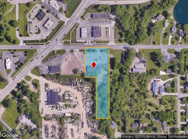
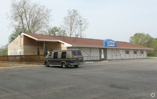
Property Record
6201 Bishop Rd, Lansing, MI 48911

NEARBY LISTINGS FOR SALE OR LEASE
-
-
-
438-462 E Edgewood Blvd & SEC American Rd & E Edgewood Blvd
Lansing, MI 48911
$16.00 SF/YR
49,265 SF
Retail
-
-
-
-
-
View all Lansing listings for sale on LoopNet.com
Property Detail
6201 Bishop Rd
Lansing-East Lansing, MI
Delhi
25-05-07-401-023
COM AT CTR OF SEC 7, TH S0?44'32E ON N-S 1/4 LN 276 FT
Restaurantbuilding
Ingham
A
Michigan
26065C0137D
6
2024
2.31 AC
2025
Southern Lansing
005202
West Michigan
4,960 SF
DEMOGRAPHICS near 6201 Bishop Rd
1 mile
3 mile
5 mile
2024 Total Population
6,447
48,235
110,002
2029 Population
6,420
48,056
109,620
Pop Growth 2024-2029
(0.42%)
(0.37%)
(0.35%)
Average Age
36
38
39
2024 Total Households
2,362
19,412
47,095
HH Growth 2024-2029
(0.55%)
(0.52%)
(0.41%)
Median Household Inc
$61,542
$50,977
$54,310
Avg Household Size
2.60
2.40
2.30
2024 Avg HH Vehicles
2.00
2.00
2.00
Median Home Value
$146,708
$134,071
$140,102
Median Year Built
1977
1971
1970
Nearby Places
Map Layers
Map Styles
 Street
 Aerial
Transit
 Traffic
 Biking
Places
Listings with unknown addresses are not visible on the map
- Restaurants
- Banks
- Shops
- Fitness
- Groceries
PUBLIC TRANSPORTATION
COMMUTER RAIL
Drive
Walk
Distance
14 min
9.7 mi
AIRPORT
Capital Region International
Drive
Walk
Distance
Capital Region International
19 min
9.2 mi
Nearby Properties
Address
Land Use
TOTAL SIZE
Lot Size
Zoning
Address
Land Use
TOTAL SIZE
Lot Size
Zoning
410 AC
Address
Land Use
TOTAL SIZE
Lot Size
Zoning
17,920 SF
208 AC
Address
Land Use
TOTAL SIZE
Lot Size
Zoning
351 SF
20.90 AC
Address
Land Use
TOTAL SIZE
Lot Size
Zoning
1,642 SF
288 AC
DM-1 RE
Address
Land Use
TOTAL SIZE
Lot Size
Zoning
50,364 SF
25.57 AC
M-1
Address
Land Use
TOTAL SIZE
Lot Size
Zoning
75,476 SF
17.70 AC
Address
Land Use
TOTAL SIZE
Lot Size
Zoning
168,480 SF
15.30 AC
G-2 WHO
Address
Land Use
TOTAL SIZE
Lot Size
Zoning
3,528 SF
230 AC
Address
Land Use
TOTAL SIZE
Lot Size
Zoning
161,686 SF
220 AC
D-1 PRO
Address
Land Use
TOTAL SIZE
Lot Size
Zoning
Address
Land Use
TOTAL SIZE
Lot Size
Zoning
8,469 SF
160 AC
Address
Land Use
TOTAL SIZE
Lot Size
Zoning
72,722 SF
3.99 AC
A-1 RES
Address
Land Use
TOTAL SIZE
Lot Size
Zoning
164 AC
Address
Land Use
TOTAL SIZE
Lot Size
Zoning
20,834 SF
11.85 AC
F COMM
Address
Land Use
TOTAL SIZE
Lot Size
Zoning
29,965 SF
4.52 AC
A-1
Address
Land Use
TOTAL SIZE
Lot Size
Zoning
1,496 SF
47.39 AC
RM-1
Address
Land Use
TOTAL SIZE
Lot Size
Zoning
138,424 SF
14.80 AC
MIXED Z
Address
Land Use
TOTAL SIZE
Lot Size
Zoning
135,318 SF
10.59 AC
G-2 WHO
Address
Land Use
TOTAL SIZE
Lot Size
Zoning
63,110 SF
8.61 AC
Address
Land Use
TOTAL SIZE
Lot Size
Zoning
60,192 SF
11.10 AC
F COMM
Address
Land Use
TOTAL SIZE
Lot Size
Zoning
72,523 SF
6.75 AC
Address
Land Use
TOTAL SIZE
Lot Size
Zoning
7,689 SF
148.47 AC
DM-1 RE
Address
Land Use
TOTAL SIZE
Lot Size
Zoning
3,006 SF
136 AC
DM-1 RE
Address
Land Use
TOTAL SIZE
Lot Size
Zoning
88,453 SF
10.94 AC
G-2 WHO
Address
Land Use
TOTAL SIZE
Lot Size
Zoning
7,874 SF
151.97 AC
PRD
Address
Land Use
TOTAL SIZE
Lot Size
Zoning
11,218 SF
2.24 AC
F COMM
Address
Land Use
TOTAL SIZE
Lot Size
Zoning
2,048 SF
38.92 AC
A-1
Address
Land Use
TOTAL SIZE
Lot Size
Zoning
5,200 SF
8.60 AC
F COMM
Address
Land Use
TOTAL SIZE
Lot Size
Zoning
140,841 SF
199 AC
CUP
Address
Land Use
TOTAL SIZE
Lot Size
Zoning
80,184 SF
104.33 AC
DM-1 RE
The World's #1 Commercial Real Estate Marketplace
Connect with us
© 2026 CoStar Group
The information above has been obtained from sources believed reliable. While we do not doubt its accuracy we have not verified it and make no guarantee, warranty or representation about it. It is your responsibility to independently confirm its accuracy and completeness. Any projections, opinions, assumptions, or estimates used are for example only and do not represent the current or future performance of the property. The value of this transaction to you depends on tax and other factors which should be evaluated by your tax, financial, and legal advisors. You and your advisors should conduct a careful, independent investigation of the property to determine to your satisfaction the suitability of the property for your needs.