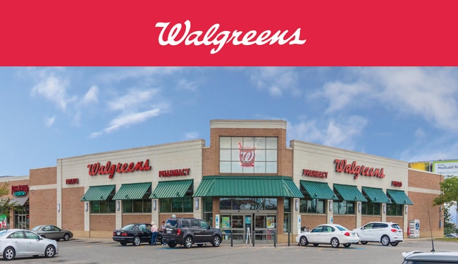
Property Record
0 E Broad St, Columbus Grove, OH 45830
Property Detail
0 E Broad St
Columbus, OH
MCNAUGHTEN RD R16 T1 1/4T3 0.463 ACRE
010-015883
FRANKLIN
Storebuilding
Ohio
B and X Area of moderate flood hazard, usually the area between the limits of the 100-year and 500-year floods.
18
2024
0.46 AC
2025
East
030500
Columbus
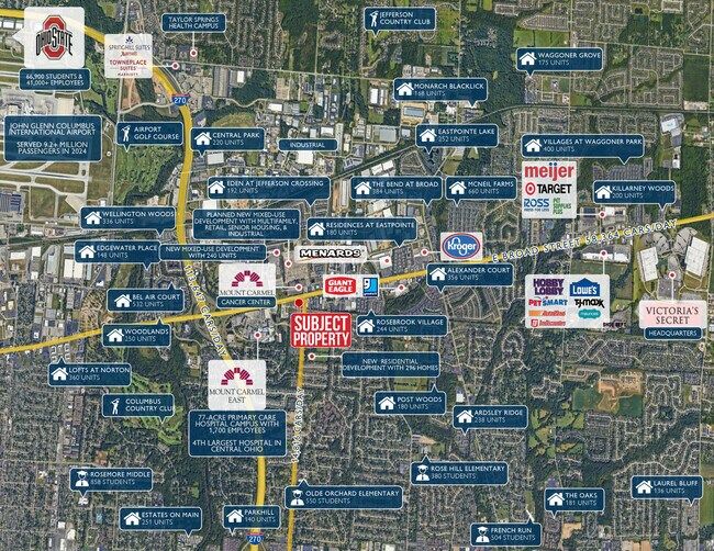
NEARBY LISTINGS FOR SALE OR LEASE
DEMOGRAPHICS near 0 E Broad St
1 mile
3 mile
5 mile
2024 Total Population
7,348
88,130
242,351
2029 Population
7,502
90,452
249,416
Pop Growth 2024-2029
+ 2.10%
+ 2.63%
+ 2.92%
Average Age
43
39
38
2024 Total Households
3,161
35,882
95,114
HH Growth 2024-2029
+ 2.15%
+ 2.76%
+ 3.03%
Median Household Inc
$89,203
$64,938
$65,818
Avg Household Size
2.30
2.40
2.50
2024 Avg HH Vehicles
2.00
2.00
2.00
Median Home Value
$299,999
$265,395
$265,641
Median Year Built
1987
1979
1978
Nearby Places
Map Layers
Map Styles
 Street
 Aerial
Transit
 Traffic
 Biking
Places
Listings with unknown addresses are not visible on the map
- Restaurants
- Banks
- Shops
- Fitness
- Groceries
PUBLIC TRANSPORTATION
AIRPORT
John Glenn Columbus International
Drive
Walk
Distance
John Glenn Columbus International
13 min
5.7 mi
Rickenbacker International
Drive
Walk
Distance
Rickenbacker International
25 min
15.0 mi
SALE & LEASE HISTORY
LISTING DATE
SALE/LEASE

Mar 26, 2018
For Sale
Mar 17, 2025
For Sale
Mar 14, 2024
For Sale
Jul 26, 2017
For Sale
Jan 23, 2020
For Sale
Apr 13, 2023
For Sale
Nearby Properties
Address
Land Use
TOTAL SIZE
Lot Size
Zoning
Address
Land Use
TOTAL SIZE
Lot Size
Zoning
Address
Land Use
TOTAL SIZE
Lot Size
Zoning
761,542 SF
21.30 AC
Address
Land Use
TOTAL SIZE
Lot Size
Zoning
180,383 SF
15.54 AC
Address
Land Use
TOTAL SIZE
Lot Size
Zoning
208,472 SF
1.45 AC
Address
Land Use
TOTAL SIZE
Lot Size
Zoning
164,095 SF
33.71 AC
Address
Land Use
TOTAL SIZE
Lot Size
Zoning
147,649 SF
5.15 AC
Address
Land Use
TOTAL SIZE
Lot Size
Zoning
122,526 SF
27 AC
Address
Land Use
TOTAL SIZE
Lot Size
Zoning
514,341 SF
46.79 AC
Address
Land Use
TOTAL SIZE
Lot Size
Zoning
282,035 SF
29.29 AC
Address
Land Use
TOTAL SIZE
Lot Size
Zoning
60,056 SF
0.22 AC
Address
Land Use
TOTAL SIZE
Lot Size
Zoning
137,136 SF
69.71 AC
Address
Land Use
TOTAL SIZE
Lot Size
Zoning
281,803 SF
20 AC
Address
Land Use
TOTAL SIZE
Lot Size
Zoning
464,796 SF
7.33 AC
Address
Land Use
TOTAL SIZE
Lot Size
Zoning
166,628 SF
9.98 AC
Address
Land Use
TOTAL SIZE
Lot Size
Zoning
217,088 SF
10.67 AC
Address
Land Use
TOTAL SIZE
Lot Size
Zoning
43,829 SF
27.86 AC
Address
Land Use
TOTAL SIZE
Lot Size
Zoning
171,366 SF
28.27 AC
Address
Land Use
TOTAL SIZE
Lot Size
Zoning
1,264,151 SF
58.42 AC
Address
Land Use
TOTAL SIZE
Lot Size
Zoning
170,209 SF
15.03 AC
Address
Land Use
TOTAL SIZE
Lot Size
Zoning
142,542 SF
6.55 AC
Address
Land Use
TOTAL SIZE
Lot Size
Zoning
188,305 SF
27.46 AC
Address
Land Use
TOTAL SIZE
Lot Size
Zoning
142,542 SF
3.95 AC
Address
Land Use
TOTAL SIZE
Lot Size
Zoning
158,325 SF
34.39 AC
Address
Land Use
TOTAL SIZE
Lot Size
Zoning
267,596 SF
5.76 AC
Address
Land Use
TOTAL SIZE
Lot Size
Zoning
264,250 SF
10.31 AC
Address
Land Use
TOTAL SIZE
Lot Size
Zoning
511,125 SF
24.90 AC
Address
Land Use
TOTAL SIZE
Lot Size
Zoning
58,272 SF
7.86 AC
Address
Land Use
TOTAL SIZE
Lot Size
Zoning
25,512 SF
18.89 AC
Address
Land Use
TOTAL SIZE
Lot Size
Zoning
176,140 SF
9.24 AC
Address
Land Use
TOTAL SIZE
Lot Size
Zoning
47,064 SF
32.95 AC
The World's #1 Commercial Real Estate Marketplace
Connect with us
© 2026 CoStar Group
The information above has been obtained from sources believed reliable. While we do not doubt its accuracy we have not verified it and make no guarantee, warranty or representation about it. It is your responsibility to independently confirm its accuracy and completeness. Any projections, opinions, assumptions, or estimates used are for example only and do not represent the current or future performance of the property. The value of this transaction to you depends on tax and other factors which should be evaluated by your tax, financial, and legal advisors. You and your advisors should conduct a careful, independent investigation of the property to determine to your satisfaction the suitability of the property for your needs.