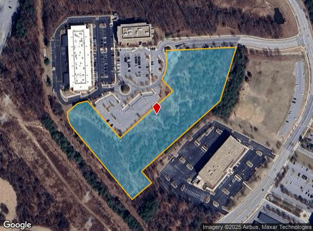
Property Record
6201 Frost Pl, Laurel, MD 20707

NEARBY LISTINGS FOR SALE OR LEASE
Property Detail
6201 Frost Pl
Washington-Arlington-Alexandria, DC-VA-MD-WV
KONTERRA AT
10-3626827
Prince George's
Industrialgeneral
Maryland
X
5
24033C0034E
7.56 AC
2024
Laurel
2025
Washington, DC
800108
DEMOGRAPHICS near 6201 Frost Pl
1 Mile
3 Mile
5 Mile
2024 Total Population
4,279
90,182
206,002
2029 Population
4,287
88,462
204,425
Pop Growth 2024-2029
+ 0.19%
(1.91%)
(0.77%)
Average Age
39
38
39
2024 Total Households
1,629
32,801
73,408
HH Growth 2024-2029
+ 0.12%
(2.09%)
(0.89%)
Median Household Inc
$125,989
$92,316
$99,864
Avg Household Size
2.60
2.70
2.70
2024 Avg HH Vehicles
2.00
2.00
2.00
Median Home Value
$484,803
$400,930
$426,962
Median Year Built
2007
1984
1984
Nearby Places
Map Layers
Map Styles
 Street
 Aerial
- Restaurants
- Banks
- Shops
- Fitness
- Groceries
PUBLIC TRANSPORTATION
COMMUTER RAIL
Muirkirk (CAMDEN - WASHINGTON - Maryland Area Regional Commuter Trains (The MARC), Camden Line - Maryland Area Regional Commuter Trains (The MARC))
DRIVE
WALK
Distance
Muirkirk (CAMDEN - WASHINGTON - Maryland Area Regional Commuter Trains (The MARC), Camden Line - Maryland Area Regional Commuter Trains (The MARC))
7 min
3.1 mi
Laurel (CAMDEN - WASHINGTON - Maryland Area Regional Commuter Trains (The MARC), Camden Line - Maryland Area Regional Commuter Trains (The MARC))
DRIVE
WALK
Distance
Laurel (CAMDEN - WASHINGTON - Maryland Area Regional Commuter Trains (The MARC), Camden Line - Maryland Area Regional Commuter Trains (The MARC))
9 min
4.4 mi
AIRPORT
Baltimore/Washington International Thurgood Marshall
DRIVE
WALK
Distance
Baltimore/Washington International Thurgood Marshall
28 min
20.2 mi
Ronald Reagan Washington Ntl
DRIVE
WALK
Distance
Ronald Reagan Washington Ntl
39 min
22.0 mi
Freight Ports
Port of Baltimore
DRIVE
WALK
Distance
Port of Baltimore
32 min
23.0 mi
Nearby Properties
Address
Land Use
TOTAL SIZE
Lot Size
Zoning
Address
Land Use
TOTAL SIZE
Lot Size
Zoning
393,970 SF
44 AC
RR
Address
Land Use
TOTAL SIZE
Lot Size
Zoning
218,406 SF
26.80 AC
LAUR
Address
Land Use
TOTAL SIZE
Lot Size
Zoning
399,715 SF
23.04 AC
LAUR
Address
Land Use
TOTAL SIZE
Lot Size
Zoning
791,089 SF
10.69 AC
LAUR
Address
Land Use
TOTAL SIZE
Lot Size
Zoning
531,312 SF
25.70 AC
R30
Address
Land Use
TOTAL SIZE
Lot Size
Zoning
657,100 SF
7.39 AC
LAUR
Address
Land Use
TOTAL SIZE
Lot Size
Zoning
514,064 SF
7.37 AC
NAC
Address
Land Use
TOTAL SIZE
Lot Size
Zoning
390,986 SF
16.87 AC
LAUR
Address
Land Use
TOTAL SIZE
Lot Size
Zoning
564,165 SF
35.85 AC
RMF12
Address
Land Use
TOTAL SIZE
Lot Size
Zoning
559,944 SF
11.89 AC
IE
Address
Land Use
TOTAL SIZE
Lot Size
Zoning
104,067 SF
25.29 AC
RMF20
Address
Land Use
TOTAL SIZE
Lot Size
Zoning
482,799 SF
17.79 AC
R30
Address
Land Use
TOTAL SIZE
Lot Size
Zoning
165,236 SF
5.24 AC
LAUR
Address
Land Use
TOTAL SIZE
Lot Size
Zoning
379,264 SF
23.08 AC
LAUR
Address
Land Use
TOTAL SIZE
Lot Size
Zoning
166,410 SF
26.25 AC
CRT1.
Address
Land Use
TOTAL SIZE
Lot Size
Zoning
310,052 SF
9.63 AC
R20
Address
Land Use
TOTAL SIZE
Lot Size
Zoning
158,316 SF
20.30 AC
LAUR
Address
Land Use
TOTAL SIZE
Lot Size
Zoning
302,887 SF
24.96 AC
LAUR
Address
Land Use
TOTAL SIZE
Lot Size
Zoning
222,345 SF
14.21 AC
R30
Address
Land Use
TOTAL SIZE
Lot Size
Zoning
16.36 AC
RMF20
Address
Land Use
TOTAL SIZE
Lot Size
Zoning
235,616 SF
12.81 AC
R30
Address
Land Use
TOTAL SIZE
Lot Size
Zoning
15.70 AC
RMF20
Address
Land Use
TOTAL SIZE
Lot Size
Zoning
4,380 SF
17.89 AC
CRT22
Address
Land Use
TOTAL SIZE
Lot Size
Zoning
456,896 SF
8.96 AC
R20
Address
Land Use
TOTAL SIZE
Lot Size
Zoning
10.52 AC
RMF20
Address
Land Use
TOTAL SIZE
Lot Size
Zoning
239,072 SF
10.41 AC
R20
Address
Land Use
TOTAL SIZE
Lot Size
Zoning
9.14 AC
LAUR
Address
Land Use
TOTAL SIZE
Lot Size
Zoning
253,396 SF
5.96 AC
LAUR
Address
Land Use
TOTAL SIZE
Lot Size
Zoning
142,372 SF
13.88 AC
LAUR
Address
Land Use
TOTAL SIZE
Lot Size
Zoning
177,712 SF
13.89 AC
GR1.5
The World's #1 Commercial Real Estate Marketplace
Connect with us
© 2025 CoStar Group
The information above has been obtained from sources believed reliable. While we do not doubt its accuracy we have not verified it and make no guarantee, warranty or representation about it. It is your responsibility to independently confirm its accuracy and completeness. Any projections, opinions, assumptions, or estimates used are for example only and do not represent the current or future performance of the property. The value of this transaction to you depends on tax and other factors which should be evaluated by your tax, financial, and legal advisors. You and your advisors should conduct a careful, independent investigation of the property to determine to your satisfaction the suitability of the property for your needs.