Property Record
6201 Lilac Dr N, Minneapolis, MN 55430
NEARBY LISTINGS FOR SALE OR LEASE
Property Detail
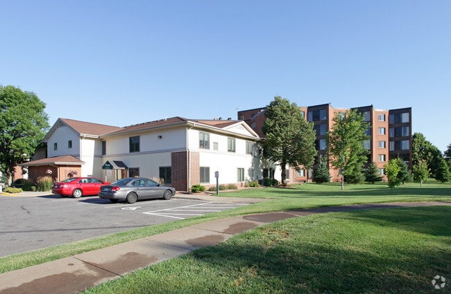
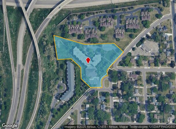
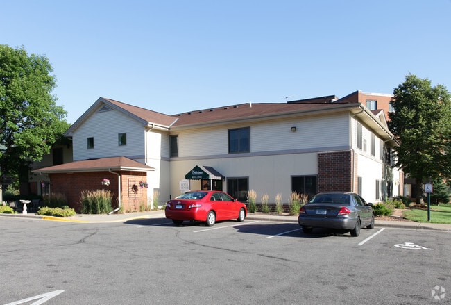
6201 Lilac Dr N
Minneapolis-St. Paul-Bloomington, MN-WI
Brookwood Residences
36-119-21-33-0167
LOT 002 BLOCK 001 B BROOKWOOD RESIDENCES TOWNHOUSE
Apartment
Hennepin
X
Minnesota
27053C0208F
2
2024
3.88 AC
2024
Brooklyn Center
020600
Minneapolis/St Paul
185,738 SF
DEMOGRAPHICS near 6201 Lilac Dr N
1 Mile
3 Mile
5 Mile
2024 Total Population
9,766
108,870
318,773
2029 Population
9,548
108,303
315,236
Pop Growth 2024-2029
(2.23%)
(0.52%)
(1.11%)
Average Age
36
37
38
2024 Total Households
3,337
38,937
119,846
HH Growth 2024-2029
(2.58%)
(0.45%)
(1.20%)
Median Household Inc
$65,166
$67,989
$69,915
Avg Household Size
2.80
2.70
2.50
2024 Avg HH Vehicles
2.00
2.00
2.00
Median Home Value
$221,289
$238,628
$256,014
Median Year Built
1964
1962
1965
Nearby Places
Map Layers
Map Styles
 Street
 Aerial
- Restaurants
- Banks
- Shops
- Fitness
- Groceries
PUBLIC TRANSPORTATION
COMMUTER RAIL
Fridley Station (Northstar Corridor - Northstar Commuter Rail)
DRIVE
WALK
Distance
Fridley Station (Northstar Corridor - Northstar Commuter Rail)
7 min
3.2 mi
Target Field Station (Northstar Corridor - Northstar Commuter Rail)
DRIVE
WALK
Distance
Target Field Station (Northstar Corridor - Northstar Commuter Rail)
15 min
7.0 mi
AIRPORT
Minneapolis-St Paul International/Wold-Chamberlain
DRIVE
WALK
Distance
Minneapolis-St Paul International/Wold-Chamberlain
33 min
18.7 mi
Freight Ports
Port Milwaukee
DRIVE
WALK
Distance
Port Milwaukee
384 min
346.6 mi
Nearby Properties
Address
Land Use
TOTAL SIZE
Lot Size
Zoning
Address
Land Use
TOTAL SIZE
Lot Size
Zoning
36.46 AC
Address
Land Use
TOTAL SIZE
Lot Size
Zoning
Address
Land Use
TOTAL SIZE
Lot Size
Zoning
66,342 SF
8.85 AC
Address
Land Use
TOTAL SIZE
Lot Size
Zoning
264,574 SF
12.71 AC
Address
Land Use
TOTAL SIZE
Lot Size
Zoning
26.73 AC
Address
Land Use
TOTAL SIZE
Lot Size
Zoning
166.50 AC
Address
Land Use
TOTAL SIZE
Lot Size
Zoning
249,357 SF
6 AC
Address
Land Use
TOTAL SIZE
Lot Size
Zoning
351,351 SF
17.98 AC
Address
Land Use
TOTAL SIZE
Lot Size
Zoning
249,884 SF
Address
Land Use
TOTAL SIZE
Lot Size
Zoning
19.10 AC
Address
Land Use
TOTAL SIZE
Lot Size
Zoning
Address
Land Use
TOTAL SIZE
Lot Size
Zoning
266,084 SF
15.60 AC
Address
Land Use
TOTAL SIZE
Lot Size
Zoning
393,252 SF
40 AC
Address
Land Use
TOTAL SIZE
Lot Size
Zoning
Address
Land Use
TOTAL SIZE
Lot Size
Zoning
255,324 SF
15.22 AC
Address
Land Use
TOTAL SIZE
Lot Size
Zoning
106,897 SF
4.37 AC
Address
Land Use
TOTAL SIZE
Lot Size
Zoning
12.37 AC
Address
Land Use
TOTAL SIZE
Lot Size
Zoning
Address
Land Use
TOTAL SIZE
Lot Size
Zoning
213,984 SF
12.21 AC
Address
Land Use
TOTAL SIZE
Lot Size
Zoning
194,221 SF
27.83 AC
Address
Land Use
TOTAL SIZE
Lot Size
Zoning
173,183 SF
18.87 AC
Address
Land Use
TOTAL SIZE
Lot Size
Zoning
Address
Land Use
TOTAL SIZE
Lot Size
Zoning
4.34 AC
Address
Land Use
TOTAL SIZE
Lot Size
Zoning
Address
Land Use
TOTAL SIZE
Lot Size
Zoning
35,762 SF
4.48 AC
Address
Land Use
TOTAL SIZE
Lot Size
Zoning
196 SF
9.81 AC
Address
Land Use
TOTAL SIZE
Lot Size
Zoning
169,628 SF
2.67 AC
Address
Land Use
TOTAL SIZE
Lot Size
Zoning
10.28 AC
Address
Land Use
TOTAL SIZE
Lot Size
Zoning
213,200 SF
13.21 AC
Address
Land Use
TOTAL SIZE
Lot Size
Zoning
190,663 SF
11.39 AC
The World's #1 Commercial Real Estate Marketplace
Connect with us
© 2025 CoStar Group
The information above has been obtained from sources believed reliable. While we do not doubt its accuracy we have not verified it and make no guarantee, warranty or representation about it. It is your responsibility to independently confirm its accuracy and completeness. Any projections, opinions, assumptions, or estimates used are for example only and do not represent the current or future performance of the property. The value of this transaction to you depends on tax and other factors which should be evaluated by your tax, financial, and legal advisors. You and your advisors should conduct a careful, independent investigation of the property to determine to your satisfaction the suitability of the property for your needs.