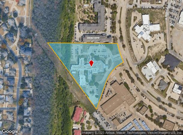
Property Record
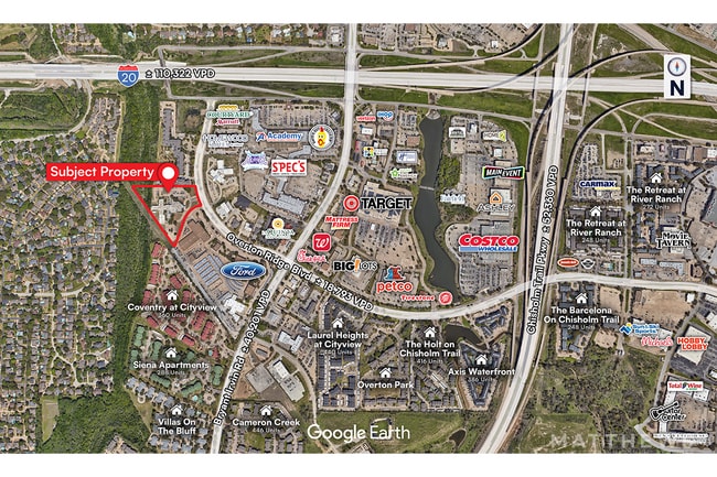
6201 Overton Ridge Blvd, Fort Worth, TX 76132


This Property Is For Sale
NEARBY LISTINGS FOR SALE OR LEASE
Property Detail
6201 Overton Ridge Blvd
Dallas-Fort Worth-Arlington, TX
City View Addition
06150624
CITY VIEW ADDITION BLOCK 3 LOT 3
Commercialnec
Tarrant
X
Texas
48439C0295K
3
2024
6.97 AC
2025
West Southwest Ft Worth
105519
Dallas/Ft Worth
52,709 SF
DEMOGRAPHICS near 6201 Overton Ridge Blvd
1 Mile
3 Mile
5 Mile
2024 Total Population
10,653
86,804
256,776
2029 Population
11,260
91,804
271,472
Pop Growth 2024-2029
+ 5.70%
+ 5.76%
+ 5.72%
Average Age
40
40
38
2024 Total Households
5,605
38,818
102,220
HH Growth 2024-2029
+ 5.83%
+ 5.93%
+ 5.90%
Median Household Inc
$57,720
$67,332
$64,006
Avg Household Size
1.80
2.20
2.40
2024 Avg HH Vehicles
1.00
2.00
2.00
Median Home Value
$436,051
$312,753
$270,587
Median Year Built
1990
1984
1981
Nearby Places
Map Layers
Map Styles
 Street
 Aerial
- Restaurants
- Banks
- Shops
- Fitness
- Groceries
PUBLIC TRANSPORTATION
COMMUTER RAIL
Texas And Pacific (T&P) (Trinity Railway Express - Dallas Area Rapid Transit (DART))
DRIVE
WALK
Distance
Texas And Pacific (T&P) (Trinity Railway Express - Dallas Area Rapid Transit (DART))
15 min
8.8 mi
Fort Worth (Heartland Flyer - Amtrak, Texas Eagle - Amtrak)
DRIVE
WALK
Distance
Fort Worth (Heartland Flyer - Amtrak, Texas Eagle - Amtrak)
15 min
9.2 mi
AIRPORT
Dallas-Fort Worth International
DRIVE
WALK
Distance
Dallas-Fort Worth International
46 min
33.6 mi
Freight Ports
Port of Shreveport
DRIVE
WALK
Distance
Port of Shreveport
251 min
233.4 mi
Nearby Properties
Address
Land Use
TOTAL SIZE
Lot Size
Zoning
Address
Land Use
TOTAL SIZE
Lot Size
Zoning
505,069 SF
6.49 AC
Address
Land Use
TOTAL SIZE
Lot Size
Zoning
438,943 SF
3.77 AC
Address
Land Use
TOTAL SIZE
Lot Size
Zoning
477,907 SF
11.83 AC
Address
Land Use
TOTAL SIZE
Lot Size
Zoning
346,920 SF
9.88 AC
Address
Land Use
TOTAL SIZE
Lot Size
Zoning
323,685 SF
19.61 AC
Address
Land Use
TOTAL SIZE
Lot Size
Zoning
401,767 SF
20.68 AC
Address
Land Use
TOTAL SIZE
Lot Size
Zoning
473,200 SF
13.79 AC
Address
Land Use
TOTAL SIZE
Lot Size
Zoning
382,376 SF
21.61 AC
Address
Land Use
TOTAL SIZE
Lot Size
Zoning
492,130 SF
6.55 AC
Address
Land Use
TOTAL SIZE
Lot Size
Zoning
373,138 SF
15 AC
Address
Land Use
TOTAL SIZE
Lot Size
Zoning
364,647 SF
17.90 AC
Address
Land Use
TOTAL SIZE
Lot Size
Zoning
344,054 SF
21.30 AC
Address
Land Use
TOTAL SIZE
Lot Size
Zoning
355,125 SF
21.29 AC
Address
Land Use
TOTAL SIZE
Lot Size
Zoning
388,957 SF
20 AC
Address
Land Use
TOTAL SIZE
Lot Size
Zoning
340,443 SF
19.02 AC
Address
Land Use
TOTAL SIZE
Lot Size
Zoning
350,654 SF
21.29 AC
Address
Land Use
TOTAL SIZE
Lot Size
Zoning
296,664 SF
14.71 AC
Address
Land Use
TOTAL SIZE
Lot Size
Zoning
347,423 SF
7.32 AC
Address
Land Use
TOTAL SIZE
Lot Size
Zoning
288,700 SF
27.02 AC
Address
Land Use
TOTAL SIZE
Lot Size
Zoning
100,000 SF
1.60 AC
Address
Land Use
TOTAL SIZE
Lot Size
Zoning
310,935 SF
14.74 AC
Address
Land Use
TOTAL SIZE
Lot Size
Zoning
312,709 SF
16.26 AC
Address
Land Use
TOTAL SIZE
Lot Size
Zoning
244,918 SF
15.52 AC
Address
Land Use
TOTAL SIZE
Lot Size
Zoning
292,450 SF
8.17 AC
Address
Land Use
TOTAL SIZE
Lot Size
Zoning
297,813 SF
13.81 AC
Address
Land Use
TOTAL SIZE
Lot Size
Zoning
267,098 SF
14.06 AC
Address
Land Use
TOTAL SIZE
Lot Size
Zoning
166,474 SF
12.60 AC
Address
Land Use
TOTAL SIZE
Lot Size
Zoning
209,329 SF
90.74 AC
Address
Land Use
TOTAL SIZE
Lot Size
Zoning
300,006 SF
15 AC
Address
Land Use
TOTAL SIZE
Lot Size
Zoning
146,395 SF
13.11 AC
The World's #1 Commercial Real Estate Marketplace
Connect with us
© 2026 CoStar Group
The information above has been obtained from sources believed reliable. While we do not doubt its accuracy we have not verified it and make no guarantee, warranty or representation about it. It is your responsibility to independently confirm its accuracy and completeness. Any projections, opinions, assumptions, or estimates used are for example only and do not represent the current or future performance of the property. The value of this transaction to you depends on tax and other factors which should be evaluated by your tax, financial, and legal advisors. You and your advisors should conduct a careful, independent investigation of the property to determine to your satisfaction the suitability of the property for your needs.