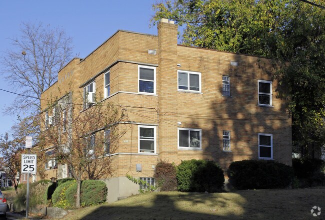
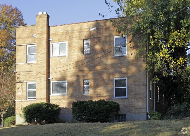
Property Record
6201 Ridge Ave, Cincinnati, OH 45213

Property Detail
6201 Ridge Ave
122-0003-0113
RIDGE AVE 39.76 X 110.22 IRR PT LOT 2 JOHN CORTELYOU SUB PARS 113-115 CONS
Apartment
Hamilton
SF4
Ohio
B and X Area of moderate flood hazard, usually the area between the limits of the 100-year and 500-year floods.
2
2025
0.10 AC
2025
Pleasant Ridge
005701
Cincinnati/Dayton
3,432 SF
Cincinnati, OH-KY-IN
NEARBY LISTINGS FOR SALE OR LEASE
DEMOGRAPHICS near 6201 Ridge Ave
1 mile
3 mile
5 mile
2025 Total Population
13,689
108,331
243,513
2030 Population
13,654
109,011
246,151
Pop Growth 2025-2030
(0.26%)
+ 0.63%
+ 1.08%
Average Age
40
40
40
2025 Total Households
6,469
50,562
107,635
HH Growth 2025-2030
(0.31%)
+ 0.61%
+ 1.10%
Median Household Inc
$70,512
$66,014
$71,379
Avg Household Size
2.10
2.10
2.20
2025 Avg HH Vehicles
2.00
2.00
2.00
Median Home Value
$278,687
$253,952
$295,039
Median Year Built
1948
1950
1952
Nearby Places
Map Layers
Map Styles
 Street
 Aerial
Layers
 Traffic
 Biking
Places
Listings with unknown addresses are not visible on the map
- Restaurants
- Banks
- Shops
- Fitness
- Groceries
PUBLIC TRANSPORTATION
AIRPORT
Cincinnati/Northern Kentucky International
Drive
Walk
Distance
Cincinnati/Northern Kentucky International
42 min
23.7 mi
Freight Ports
Port of Toledo
Drive
Walk
Distance
Port of Toledo
239 min
200.5 mi
Nearby Properties
Address
Land Use
TOTAL SIZE
Lot Size
Zoning
Address
Land Use
TOTAL SIZE
Lot Size
Zoning
31.26 AC
E
Address
Land Use
TOTAL SIZE
Lot Size
Zoning
8.11 AC
E
Address
Land Use
TOTAL SIZE
Lot Size
Zoning
317,592 SF
29.46 AC
E
Address
Land Use
TOTAL SIZE
Lot Size
Zoning
12.43 AC
OO
Address
Land Use
TOTAL SIZE
Lot Size
Zoning
Address
Land Use
TOTAL SIZE
Lot Size
Zoning
Address
Land Use
TOTAL SIZE
Lot Size
Zoning
148,748 SF
24.90 AC
CGA
Address
Land Use
TOTAL SIZE
Lot Size
Zoning
3.17 AC
R2PUD
Address
Land Use
TOTAL SIZE
Lot Size
Zoning
9.16 AC
Address
Land Use
TOTAL SIZE
Lot Size
Zoning
Address
Land Use
TOTAL SIZE
Lot Size
Zoning
10.76 AC
Address
Land Use
TOTAL SIZE
Lot Size
Zoning
8.05 AC
Address
Land Use
TOTAL SIZE
Lot Size
Zoning
15.91 AC
E
Address
Land Use
TOTAL SIZE
Lot Size
Zoning
5.07 AC
Address
Land Use
TOTAL SIZE
Lot Size
Zoning
Address
Land Use
TOTAL SIZE
Lot Size
Zoning
6.93 AC
MG
Address
Land Use
TOTAL SIZE
Lot Size
Zoning
1,238 SF
14.03 AC
Address
Land Use
TOTAL SIZE
Lot Size
Zoning
Address
Land Use
TOTAL SIZE
Lot Size
Zoning
0.26 AC
RM12
Address
Land Use
TOTAL SIZE
Lot Size
Zoning
29.67 AC
RM20
Address
Land Use
TOTAL SIZE
Lot Size
Zoning
6.91 AC
Address
Land Use
TOTAL SIZE
Lot Size
Zoning
3,864 SF
0.15 AC
PD
Address
Land Use
TOTAL SIZE
Lot Size
Zoning
4.57 AC
Address
Land Use
TOTAL SIZE
Lot Size
Zoning
4,706 SF
18.29 AC
RM20
Address
Land Use
TOTAL SIZE
Lot Size
Zoning
7.06 AC
Address
Land Use
TOTAL SIZE
Lot Size
Zoning
6.80 AC
Address
Land Use
TOTAL SIZE
Lot Size
Zoning
1,152 SF
24.78 AC
B
Address
Land Use
TOTAL SIZE
Lot Size
Zoning
5.79 AC
Address
Land Use
TOTAL SIZE
Lot Size
Zoning
18.51 AC
RM20
Address
Land Use
TOTAL SIZE
Lot Size
Zoning
1,187 SF
31.75 AC
ML
The World's #1 Commercial Real Estate Marketplace
Connect with us
© 2026 CoStar Group
The information above has been obtained from sources believed reliable. While we do not doubt its accuracy we have not verified it and make no guarantee, warranty or representation about it. It is your responsibility to independently confirm its accuracy and completeness. Any projections, opinions, assumptions, or estimates used are for example only and do not represent the current or future performance of the property. The value of this transaction to you depends on tax and other factors which should be evaluated by your tax, financial, and legal advisors. You and your advisors should conduct a careful, independent investigation of the property to determine to your satisfaction the suitability of the property for your needs.