Property Record
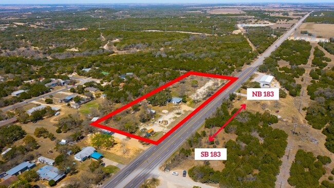
6201 N Highway 183, Liberty Hill, TX 78642


NEARBY LISTINGS FOR SALE OR LEASE
Property Detail
6201 N Highway 183
R022246
I. & G.N.R.R. Co. Sur.
Residentialacreage
AW0338 AW0338 - I. & G.N.R.R. CO. SUR., ACRES 3.53
X
Williamson
48491C0235F
Texas
2024
3.53 AC
2025
Georgetown
020208
Austin
1,520 SF
Austin-Round Rock-San Marcos, TX
DEMOGRAPHICS near 6201 N Highway 183
1 Mile
3 Mile
5 Mile
2024 Total Population
835
3,695
12,000
2029 Population
1,077
4,724
15,337
Pop Growth 2024-2029
+ 28.98%
+ 27.85%
+ 27.81%
Average Age
40
41
41
2024 Total Households
276
1,269
4,078
HH Growth 2024-2029
+ 29.35%
+ 28.29%
+ 28.25%
Median Household Inc
$124,999
$131,250
$128,580
Avg Household Size
3.00
2.90
2.90
2024 Avg HH Vehicles
3.00
3.00
3.00
Median Home Value
$653,614
$613,739
$605,539
Median Year Built
2010
2010
2010
Nearby Places
Map Layers
Map Styles
 Street
 Aerial
- Restaurants
- Banks
- Shops
- Fitness
- Groceries
PUBLIC TRANSPORTATION
AIRPORT
Robert Gray AAF
DRIVE
WALK
Distance
Robert Gray AAF
40 min
28.5 mi
Killeen Municipal
DRIVE
WALK
Distance
Killeen Municipal
45 min
37.1 mi
SALE & LEASE HISTORY
LISTING DATE
SALE/LEASE

Apr 08, 2022
For Sale
Nearby Properties
Address
Land Use
TOTAL SIZE
Lot Size
Zoning
Address
Land Use
TOTAL SIZE
Lot Size
Zoning
129.94 AC
Address
Land Use
TOTAL SIZE
Lot Size
Zoning
21,640 SF
5 AC
Address
Land Use
TOTAL SIZE
Lot Size
Zoning
2,475 SF
41.70 AC
Address
Land Use
TOTAL SIZE
Lot Size
Zoning
766 SF
14.03 AC
Address
Land Use
TOTAL SIZE
Lot Size
Zoning
171.90 AC
Address
Land Use
TOTAL SIZE
Lot Size
Zoning
3,168 SF
149.88 AC
Address
Land Use
TOTAL SIZE
Lot Size
Zoning
2,331 SF
4.17 AC
Address
Land Use
TOTAL SIZE
Lot Size
Zoning
2,400 SF
15.01 AC
Address
Land Use
TOTAL SIZE
Lot Size
Zoning
19,401 SF
20.32 AC
Address
Land Use
TOTAL SIZE
Lot Size
Zoning
12.89 AC
Address
Land Use
TOTAL SIZE
Lot Size
Zoning
12.89 AC
Address
Land Use
TOTAL SIZE
Lot Size
Zoning
17,832 SF
5.98 AC
Address
Land Use
TOTAL SIZE
Lot Size
Zoning
14,045 SF
27.60 AC
Address
Land Use
TOTAL SIZE
Lot Size
Zoning
4,440 SF
9.38 AC
Address
Land Use
TOTAL SIZE
Lot Size
Zoning
Address
Land Use
TOTAL SIZE
Lot Size
Zoning
61.88 AC
Address
Land Use
TOTAL SIZE
Lot Size
Zoning
9,545 SF
3.21 AC
Address
Land Use
TOTAL SIZE
Lot Size
Zoning
11,533 SF
26.47 AC
Address
Land Use
TOTAL SIZE
Lot Size
Zoning
545 SF
22 AC
Address
Land Use
TOTAL SIZE
Lot Size
Zoning
10,000 SF
3.61 AC
Address
Land Use
TOTAL SIZE
Lot Size
Zoning
10,832 SF
4.69 AC
Address
Land Use
TOTAL SIZE
Lot Size
Zoning
3,200 SF
17.83 AC
Address
Land Use
TOTAL SIZE
Lot Size
Zoning
192 SF
12.96 AC
Address
Land Use
TOTAL SIZE
Lot Size
Zoning
6,000 SF
3.05 AC
Address
Land Use
TOTAL SIZE
Lot Size
Zoning
9,000 SF
1.40 AC
Address
Land Use
TOTAL SIZE
Lot Size
Zoning
10.02 AC
Address
Land Use
TOTAL SIZE
Lot Size
Zoning
5,046 SF
12.06 AC
Address
Land Use
TOTAL SIZE
Lot Size
Zoning
5,290 SF
9.02 AC
Address
Land Use
TOTAL SIZE
Lot Size
Zoning
4,668 SF
4.77 AC
Address
Land Use
TOTAL SIZE
Lot Size
Zoning
10,840 SF
0.50 AC
The World's #1 Commercial Real Estate Marketplace
Connect with us
© 2026 CoStar Group
The information above has been obtained from sources believed reliable. While we do not doubt its accuracy we have not verified it and make no guarantee, warranty or representation about it. It is your responsibility to independently confirm its accuracy and completeness. Any projections, opinions, assumptions, or estimates used are for example only and do not represent the current or future performance of the property. The value of this transaction to you depends on tax and other factors which should be evaluated by your tax, financial, and legal advisors. You and your advisors should conduct a careful, independent investigation of the property to determine to your satisfaction the suitability of the property for your needs.