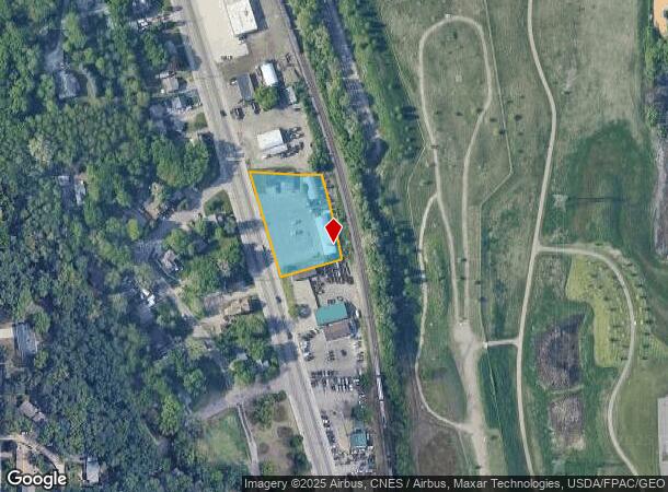
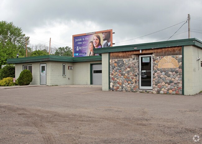
Property Record
6202 Concord Blvd, Inver Grove Heights, MN 55076

NEARBY LISTINGS FOR SALE OR LEASE
Property Detail
6202 Concord Blvd
Minneapolis-St. Paul-Bloomington, MN-WI
Inver Grove Factory Add
20-36500-21-060
6 21 ALL OF LOTS 1 THRU 6 TOGETHER WITH PT OF VAC CHESTER ST ADJ TO LOT 1 & LY S'LY OF LINE COM NW COR NW 1/4 2-27-22 THENCE N 89D54M54S ON N L NW 1/4 661 .02FT SE'LY ON CUR 296.93 FT CA 1D29M05S S 16D53M43S E TAN TO CUR 316.42 FT TO BEG OF LINE S 89
Industrialgeneral
Dakota
X
Minnesota
27037C0107E
60
2023
0.96 AC
2024
Suburban St Paul
060502
Minneapolis/St Paul
5,027 SF
DEMOGRAPHICS near 6202 Concord Blvd
1 Mile
3 Mile
5 Mile
2024 Total Population
4,799
56,860
141,525
2029 Population
4,936
58,841
148,175
Pop Growth 2024-2029
+ 2.85%
+ 3.48%
+ 4.70%
Average Age
39
40
40
2024 Total Households
1,828
22,815
55,309
HH Growth 2024-2029
+ 2.90%
+ 3.36%
+ 4.59%
Median Household Inc
$77,900
$79,123
$84,221
Avg Household Size
2.50
2.40
2.50
2024 Avg HH Vehicles
2.00
2.00
2.00
Median Home Value
$248,135
$280,718
$299,528
Median Year Built
1968
1978
1982
Nearby Places
Map Layers
Map Styles
 Street
 Aerial
- Restaurants
- Banks
- Shops
- Fitness
- Groceries
PUBLIC TRANSPORTATION
COMMUTER RAIL
DRIVE
WALK
Distance
13 min
8.6 mi
AIRPORT
Minneapolis-St Paul International/Wold-Chamberlain
DRIVE
WALK
Distance
Minneapolis-St Paul International/Wold-Chamberlain
20 min
12.2 mi
Nearby Properties
Address
Land Use
TOTAL SIZE
Lot Size
Zoning
Address
Land Use
TOTAL SIZE
Lot Size
Zoning
Address
Land Use
TOTAL SIZE
Lot Size
Zoning
146,085 SF
46.83 AC
Address
Land Use
TOTAL SIZE
Lot Size
Zoning
293,970 SF
31.92 AC
Address
Land Use
TOTAL SIZE
Lot Size
Zoning
196,078 SF
31.29 AC
Address
Land Use
TOTAL SIZE
Lot Size
Zoning
605,774 SF
44.50 AC
Address
Land Use
TOTAL SIZE
Lot Size
Zoning
228,050 SF
0.32 AC
Address
Land Use
TOTAL SIZE
Lot Size
Zoning
71,164 SF
10.79 AC
Address
Land Use
TOTAL SIZE
Lot Size
Zoning
Address
Land Use
TOTAL SIZE
Lot Size
Zoning
163,985 SF
7.06 AC
Address
Land Use
TOTAL SIZE
Lot Size
Zoning
169,237 SF
23.38 AC
Address
Land Use
TOTAL SIZE
Lot Size
Zoning
482,008 SF
23.78 AC
Address
Land Use
TOTAL SIZE
Lot Size
Zoning
452,836 SF
17.81 AC
Address
Land Use
TOTAL SIZE
Lot Size
Zoning
Address
Land Use
TOTAL SIZE
Lot Size
Zoning
532,778 SF
4.99 AC
Address
Land Use
TOTAL SIZE
Lot Size
Zoning
138,609 SF
3.76 AC
Address
Land Use
TOTAL SIZE
Lot Size
Zoning
Address
Land Use
TOTAL SIZE
Lot Size
Zoning
41,040 SF
11.38 AC
Address
Land Use
TOTAL SIZE
Lot Size
Zoning
236,378 SF
7.57 AC
Address
Land Use
TOTAL SIZE
Lot Size
Zoning
150,469 SF
10.73 AC
Address
Land Use
TOTAL SIZE
Lot Size
Zoning
152,098 SF
8.23 AC
Address
Land Use
TOTAL SIZE
Lot Size
Zoning
174,820 SF
7.79 AC
Address
Land Use
TOTAL SIZE
Lot Size
Zoning
28,461 SF
16.13 AC
Address
Land Use
TOTAL SIZE
Lot Size
Zoning
151,959 SF
0.32 AC
Address
Land Use
TOTAL SIZE
Lot Size
Zoning
219,438 SF
90.20 AC
Address
Land Use
TOTAL SIZE
Lot Size
Zoning
143,712 SF
9.57 AC
Address
Land Use
TOTAL SIZE
Lot Size
Zoning
290,362 SF
12.83 AC
Address
Land Use
TOTAL SIZE
Lot Size
Zoning
161,676 SF
13.90 AC
Address
Land Use
TOTAL SIZE
Lot Size
Zoning
95,693 SF
3.64 AC
Address
Land Use
TOTAL SIZE
Lot Size
Zoning
87,080 SF
2.16 AC
Address
Land Use
TOTAL SIZE
Lot Size
Zoning
67,370 SF
1.18 AC
The World's #1 Commercial Real Estate Marketplace
Connect with us
© 2025 CoStar Group
The information above has been obtained from sources believed reliable. While we do not doubt its accuracy we have not verified it and make no guarantee, warranty or representation about it. It is your responsibility to independently confirm its accuracy and completeness. Any projections, opinions, assumptions, or estimates used are for example only and do not represent the current or future performance of the property. The value of this transaction to you depends on tax and other factors which should be evaluated by your tax, financial, and legal advisors. You and your advisors should conduct a careful, independent investigation of the property to determine to your satisfaction the suitability of the property for your needs.