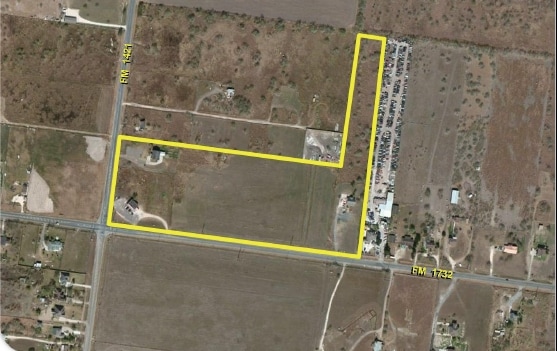
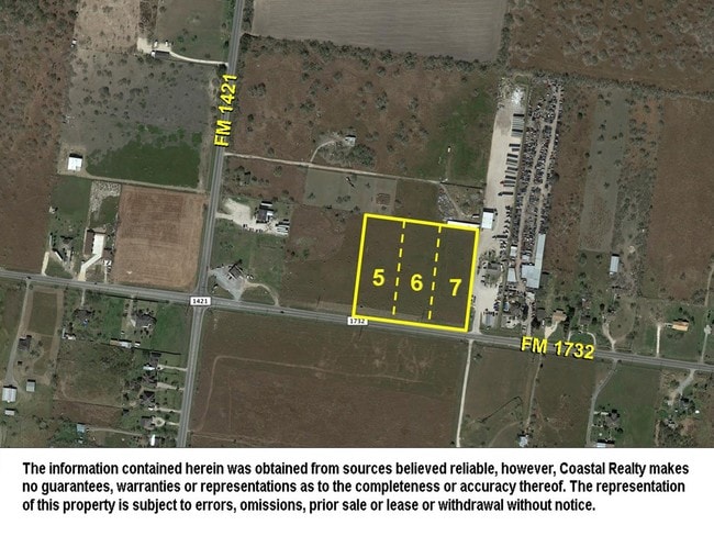
Property Record
6205 Fm 1732, Brownsville, TX 78520

NEARBY LISTINGS FOR SALE OR LEASE
Property Detail
6205 Fm 1732
Brownsville-Harlingen, TX
Barreda Gardens Subdivision
735590-0140-024100
BARREDA GARDENS SUBDIVISION LOT 24, BLK 14 W5 ACRES OF THE W10, 5.0000 ACS
Commercialnec
Cameron
AO
Texas
48061C0440F
24
2024
5 AC
2025
Outlying Cameron County
012506
Brownsville/Harlingen
6,522 SF
DEMOGRAPHICS near 6205 Fm 1732
1 Mile
3 Mile
5 Mile
2024 Total Population
1,064
10,665
37,454
2029 Population
1,095
11,103
38,807
Pop Growth 2024-2029
+ 2.91%
+ 4.11%
+ 3.61%
Average Age
32
36
34
2024 Total Households
264
3,192
10,449
HH Growth 2024-2029
+ 3.03%
+ 4.39%
+ 3.80%
Median Household Inc
$41,000
$67,989
$71,578
Avg Household Size
3.80
3.30
3.50
2024 Avg HH Vehicles
2.00
2.00
2.00
Median Home Value
$91,128
$160,091
$155,854
Median Year Built
2002
1996
2003
Nearby Places
Map Layers
Map Styles
 Street
 Aerial
- Restaurants
- Banks
- Shops
- Fitness
- Groceries
PUBLIC TRANSPORTATION
AIRPORT
Brownsville/South Padre Island International
DRIVE
WALK
Distance
Brownsville/South Padre Island International
23 min
14.6 mi
Valley International
DRIVE
WALK
Distance
Valley International
28 min
18.4 mi
Freight Ports
Port of Brownsville
DRIVE
WALK
Distance
Port of Brownsville
19 min
14.0 mi
SALE & LEASE HISTORY
LISTING DATE
SALE/LEASE

Oct 05, 2017
For Sale
Nearby Properties
Address
Land Use
TOTAL SIZE
Lot Size
Zoning
Address
Land Use
TOTAL SIZE
Lot Size
Zoning
122,224 SF
9.93 AC
Address
Land Use
TOTAL SIZE
Lot Size
Zoning
121,377 SF
12.63 AC
Address
Land Use
TOTAL SIZE
Lot Size
Zoning
1,059.47 AC
Address
Land Use
TOTAL SIZE
Lot Size
Zoning
9,071 SF
0.82 AC
Address
Land Use
TOTAL SIZE
Lot Size
Zoning
24,730 SF
6.86 AC
Address
Land Use
TOTAL SIZE
Lot Size
Zoning
9,016 SF
2 AC
Address
Land Use
TOTAL SIZE
Lot Size
Zoning
25,212 SF
8.01 AC
A-C
Address
Land Use
TOTAL SIZE
Lot Size
Zoning
25,023 SF
7.54 AC
A-C
Address
Land Use
TOTAL SIZE
Lot Size
Zoning
13,750 SF
24.24 AC
Address
Land Use
TOTAL SIZE
Lot Size
Zoning
28,800 SF
1.29 AC
Address
Land Use
TOTAL SIZE
Lot Size
Zoning
4,750 SF
1.73 AC
Address
Land Use
TOTAL SIZE
Lot Size
Zoning
2,682 SF
18.01 AC
A-C
Address
Land Use
TOTAL SIZE
Lot Size
Zoning
8,396 SF
0.66 AC
Address
Land Use
TOTAL SIZE
Lot Size
Zoning
5,850 SF
5.19 AC
A-R
Address
Land Use
TOTAL SIZE
Lot Size
Zoning
28,248 SF
3.56 AC
C
Address
Land Use
TOTAL SIZE
Lot Size
Zoning
19,740 SF
10 AC
C
Address
Land Use
TOTAL SIZE
Lot Size
Zoning
424 SF
18 AC
A-C
Address
Land Use
TOTAL SIZE
Lot Size
Zoning
8,400 SF
0.96 AC
Address
Land Use
TOTAL SIZE
Lot Size
Zoning
11,422 SF
2.34 AC
Address
Land Use
TOTAL SIZE
Lot Size
Zoning
3,957 SF
5 AC
A-R
Address
Land Use
TOTAL SIZE
Lot Size
Zoning
7,647 SF
1.09 AC
Address
Land Use
TOTAL SIZE
Lot Size
Zoning
8,284 SF
1.67 AC
Address
Land Use
TOTAL SIZE
Lot Size
Zoning
11,100 SF
11.10 AC
Address
Land Use
TOTAL SIZE
Lot Size
Zoning
6,804 SF
0.43 AC
A-R
Address
Land Use
TOTAL SIZE
Lot Size
Zoning
3,520 SF
5 AC
A-R
Address
Land Use
TOTAL SIZE
Lot Size
Zoning
5,504 SF
0.60 AC
A-R
Address
Land Use
TOTAL SIZE
Lot Size
Zoning
8,688 SF
5.60 AC
Address
Land Use
TOTAL SIZE
Lot Size
Zoning
5,600 SF
0.16 AC
Address
Land Use
TOTAL SIZE
Lot Size
Zoning
8,462 SF
1.29 AC
The World's #1 Commercial Real Estate Marketplace
Connect with us
© 2026 CoStar Group
The information above has been obtained from sources believed reliable. While we do not doubt its accuracy we have not verified it and make no guarantee, warranty or representation about it. It is your responsibility to independently confirm its accuracy and completeness. Any projections, opinions, assumptions, or estimates used are for example only and do not represent the current or future performance of the property. The value of this transaction to you depends on tax and other factors which should be evaluated by your tax, financial, and legal advisors. You and your advisors should conduct a careful, independent investigation of the property to determine to your satisfaction the suitability of the property for your needs.