Property Record
26111 63Rd St, Bangor, MI 49013
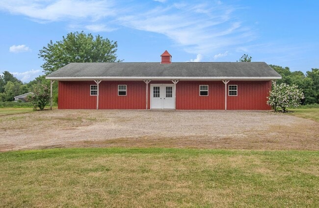
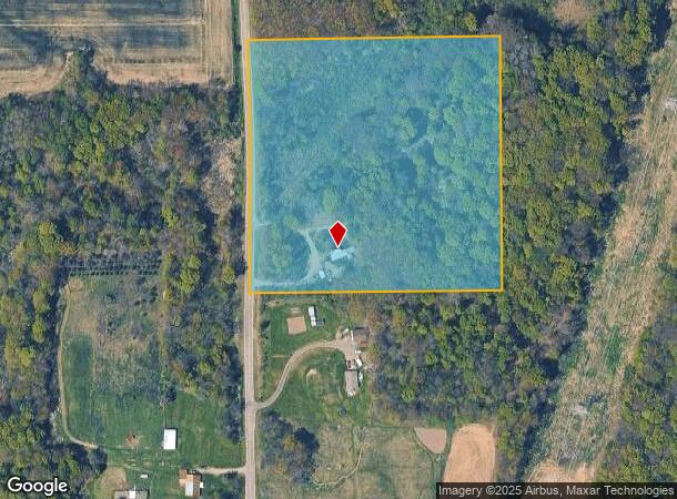
This Property Is For Sale
NEARBY LISTINGS FOR SALE OR LEASE
-
-
View all Bangor listings for sale on LoopNet.com
Property Detail
26111 63Rd St
80-04-003-010-00
Van Buren
Sfr
Michigan
X
9.50 AC
26159C0175C
Van Buren County
924 SF
West Michigan
DEMOGRAPHICS near 26111 63Rd St
1 Mile
3 Mile
5 Mile
2024 Total Population
312
3,692
7,455
2029 Population
317
3,717
7,565
Pop Growth 2024-2029
+ 1.60%
+ 0.68%
+ 1.48%
Average Age
39
39
40
2024 Total Households
113
1,335
2,721
HH Growth 2024-2029
+ 0.88%
+ 0.60%
+ 1.32%
Median Household Inc
$44,166
$58,563
$59,453
Avg Household Size
2.60
2.60
2.60
2024 Avg HH Vehicles
2.00
2.00
2.00
Median Home Value
$163,888
$155,434
$164,354
Median Year Built
1977
1972
1975
Nearby Places
Map Layers
Map Styles
 Street
 Aerial
- Restaurants
- Banks
- Shops
- Fitness
- Groceries
PUBLIC TRANSPORTATION
COMMUTER RAIL
DRIVE
WALK
Distance
7 min
3.3 mi
AIRPORT
Kalamazoo/Battle Creek International
DRIVE
WALK
Distance
Kalamazoo/Battle Creek International
59 min
36.7 mi
Nearby Properties
Address
Land Use
TOTAL SIZE
Lot Size
Zoning
Address
Land Use
TOTAL SIZE
Lot Size
Zoning
6,627 SF
Address
Land Use
TOTAL SIZE
Lot Size
Zoning
Address
Land Use
TOTAL SIZE
Lot Size
Zoning
80,333 SF
26.36 AC
M-1 INDSTR
Address
Land Use
TOTAL SIZE
Lot Size
Zoning
22,424 SF
12.46 AC
I-1
Address
Land Use
TOTAL SIZE
Lot Size
Zoning
37,762 SF
18.50 AC
NO ZONI
Address
Land Use
TOTAL SIZE
Lot Size
Zoning
3,802 SF
40 AC
UNZONED
Address
Land Use
TOTAL SIZE
Lot Size
Zoning
32,321 SF
9.88 AC
R3
Address
Land Use
TOTAL SIZE
Lot Size
Zoning
12,000 SF
3.96 AC
I-1
Address
Land Use
TOTAL SIZE
Lot Size
Zoning
12,000 SF
4.25 AC
I-1
Address
Land Use
TOTAL SIZE
Lot Size
Zoning
28,560 SF
2.14 AC
I-1
Address
Land Use
TOTAL SIZE
Lot Size
Zoning
1,792 SF
63.29 AC
AG
Address
Land Use
TOTAL SIZE
Lot Size
Zoning
160 AC
NO ZONI
Address
Land Use
TOTAL SIZE
Lot Size
Zoning
24,192 SF
2.83 AC
R3
Address
Land Use
TOTAL SIZE
Lot Size
Zoning
52 AC
NO ZONI
Address
Land Use
TOTAL SIZE
Lot Size
Zoning
2,540 SF
93.40 AC
NO ZONI
Address
Land Use
TOTAL SIZE
Lot Size
Zoning
40,196 SF
5.14 AC
R1
Address
Land Use
TOTAL SIZE
Lot Size
Zoning
2,560 SF
155 AC
UNZONED
Address
Land Use
TOTAL SIZE
Lot Size
Zoning
23,506 SF
1.81 AC
B2
Address
Land Use
TOTAL SIZE
Lot Size
Zoning
12,096 SF
2.50 AC
R3
Address
Land Use
TOTAL SIZE
Lot Size
Zoning
2,820 SF
40 AC
UNZONED
Address
Land Use
TOTAL SIZE
Lot Size
Zoning
9,644 SF
2.09 AC
I-1
Address
Land Use
TOTAL SIZE
Lot Size
Zoning
1,888 SF
80 AC
NO ZONI
Address
Land Use
TOTAL SIZE
Lot Size
Zoning
142 AC
AG
Address
Land Use
TOTAL SIZE
Lot Size
Zoning
9,277 SF
1.42 AC
B1
Address
Land Use
TOTAL SIZE
Lot Size
Zoning
120.40 AC
NO ZONI
Address
Land Use
TOTAL SIZE
Lot Size
Zoning
1,144 SF
40 AC
UNZONED
Address
Land Use
TOTAL SIZE
Lot Size
Zoning
2,684 SF
80 AC
NO ZONI
Address
Land Use
TOTAL SIZE
Lot Size
Zoning
2,294 SF
42.50 AC
NO ZONI
Address
Land Use
TOTAL SIZE
Lot Size
Zoning
115 AC
NO ZONI
Address
Land Use
TOTAL SIZE
Lot Size
Zoning
118 AC
NO ZONI
The World's #1 Commercial Real Estate Marketplace
Connect with us
© 2026 CoStar Group
The information above has been obtained from sources believed reliable. While we do not doubt its accuracy we have not verified it and make no guarantee, warranty or representation about it. It is your responsibility to independently confirm its accuracy and completeness. Any projections, opinions, assumptions, or estimates used are for example only and do not represent the current or future performance of the property. The value of this transaction to you depends on tax and other factors which should be evaluated by your tax, financial, and legal advisors. You and your advisors should conduct a careful, independent investigation of the property to determine to your satisfaction the suitability of the property for your needs.