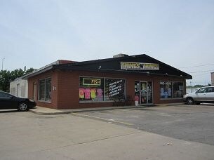
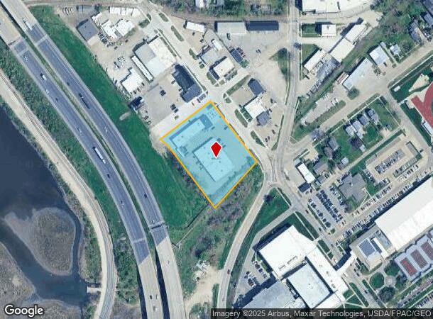
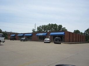
Property Record
621 Center Point Rd Ne, Cedar Rapids, IA 52402
NEARBY LISTINGS FOR SALE OR LEASE
Property Detail
621 Center Point Rd Ne
14211-07008-00000
Regency North
Regionalshoppingcenterormallwithanchorstore
A.P. #47 NE 400 BLK 5 LYG NW OF IA ELEC LT & PWR CO 30 STRIP EX SW150 & P.O.S. #2666 PARCEL B
X
Linn
19113C0410E
Iowa
2023
1.92 AC
2025
Iowa City/Waterloo
001300
Other Market Areas
21,898 SF
Cedar Rapids, IA
DEMOGRAPHICS near 621 Center Point Rd Ne
1 Mile
3 Mile
5 Mile
2024 Total Population
11,273
76,499
152,628
2029 Population
11,281
76,241
152,119
Pop Growth 2024-2029
+ 0.07%
(0.34%)
(0.33%)
Average Age
37
40
40
2024 Total Households
4,637
33,406
64,981
HH Growth 2024-2029
+ 0.35%
(0.36%)
(0.33%)
Median Household Inc
$43,404
$59,283
$62,723
Avg Household Size
2.10
2.10
2.20
2024 Avg HH Vehicles
2.00
2.00
2.00
Median Home Value
$136,577
$158,728
$171,811
Median Year Built
1948
1960
1971
Nearby Places
Map Layers
Map Styles
 Street
 Aerial
- Restaurants
- Banks
- Shops
- Fitness
- Groceries
PUBLIC TRANSPORTATION
AIRPORT
The Eastern Iowa
DRIVE
WALK
Distance
The Eastern Iowa
15 min
9.7 mi
Nearby Properties
Address
Land Use
TOTAL SIZE
Lot Size
Zoning
Address
Land Use
TOTAL SIZE
Lot Size
Zoning
429,314 SF
14.92 AC
Address
Land Use
TOTAL SIZE
Lot Size
Zoning
355,567 SF
14.60 AC
Address
Land Use
TOTAL SIZE
Lot Size
Zoning
171,842 SF
4.16 AC
Address
Land Use
TOTAL SIZE
Lot Size
Zoning
264,086 SF
21.44 AC
Address
Land Use
TOTAL SIZE
Lot Size
Zoning
218,747 SF
9.45 AC
Address
Land Use
TOTAL SIZE
Lot Size
Zoning
308,309 SF
17.97 AC
Address
Land Use
TOTAL SIZE
Lot Size
Zoning
530,727 SF
28.94 AC
Address
Land Use
TOTAL SIZE
Lot Size
Zoning
65,970 SF
2.07 AC
Address
Land Use
TOTAL SIZE
Lot Size
Zoning
73,012 SF
2.60 AC
Address
Land Use
TOTAL SIZE
Lot Size
Zoning
276,234 SF
44.53 AC
Address
Land Use
TOTAL SIZE
Lot Size
Zoning
70,022 SF
8.27 AC
Address
Land Use
TOTAL SIZE
Lot Size
Zoning
125,013 SF
0.97 AC
Address
Land Use
TOTAL SIZE
Lot Size
Zoning
60,910 SF
2.48 AC
Address
Land Use
TOTAL SIZE
Lot Size
Zoning
97,612 SF
0.89 AC
Address
Land Use
TOTAL SIZE
Lot Size
Zoning
140,672 SF
15.99 AC
Address
Land Use
TOTAL SIZE
Lot Size
Zoning
74,015 SF
6.59 AC
Address
Land Use
TOTAL SIZE
Lot Size
Zoning
67,971 SF
Address
Land Use
TOTAL SIZE
Lot Size
Zoning
36,803 SF
2.53 AC
Address
Land Use
TOTAL SIZE
Lot Size
Zoning
23,585 SF
1.05 AC
Address
Land Use
TOTAL SIZE
Lot Size
Zoning
110,583 SF
15.56 AC
Address
Land Use
TOTAL SIZE
Lot Size
Zoning
80,530 SF
2.96 AC
Address
Land Use
TOTAL SIZE
Lot Size
Zoning
32,855 SF
1.37 AC
Address
Land Use
TOTAL SIZE
Lot Size
Zoning
56,178 SF
0.97 AC
Address
Land Use
TOTAL SIZE
Lot Size
Zoning
45,012 SF
0.85 AC
Address
Land Use
TOTAL SIZE
Lot Size
Zoning
22,400 SF
0.40 AC
Address
Land Use
TOTAL SIZE
Lot Size
Zoning
45,098 SF
3.02 AC
Address
Land Use
TOTAL SIZE
Lot Size
Zoning
198,251 SF
16.85 AC
Address
Land Use
TOTAL SIZE
Lot Size
Zoning
39,271 SF
0.66 AC
Address
Land Use
TOTAL SIZE
Lot Size
Zoning
28,506 SF
5.30 AC
Address
Land Use
TOTAL SIZE
Lot Size
Zoning
67,108 SF
4.81 AC
The World's #1 Commercial Real Estate Marketplace
Connect with us
© 2025 CoStar Group
The information above has been obtained from sources believed reliable. While we do not doubt its accuracy we have not verified it and make no guarantee, warranty or representation about it. It is your responsibility to independently confirm its accuracy and completeness. Any projections, opinions, assumptions, or estimates used are for example only and do not represent the current or future performance of the property. The value of this transaction to you depends on tax and other factors which should be evaluated by your tax, financial, and legal advisors. You and your advisors should conduct a careful, independent investigation of the property to determine to your satisfaction the suitability of the property for your needs.