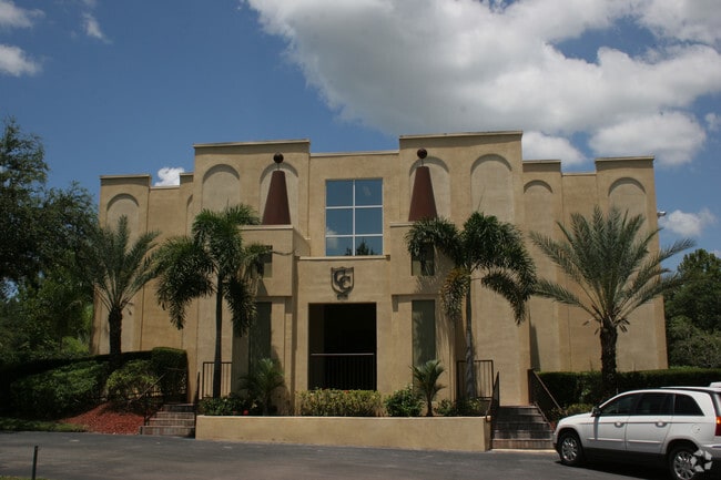
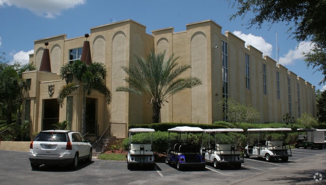
Property Record
6210 579 Hwy, Seffner, FL 33584


NEARBY LISTINGS FOR SALE OR LEASE
-
-
View all Seffner listings for sale on LoopNet.com
Property Detail
6210 579 Hwy
Tampa-St. Petersburg-Clearwater, FL
Unplatted
U-28-28-20-ZZZ-000002-23020.0
SE 1/4 OF SE 1/4 LESS E 30 FT AND LESS S 33 FT AND LESS LOT BEG 34.74 FT N AND 33 FT W OF SE COR AND RUN N 37 FT S 45 DEG 44 MIN 18 SEC W 52.94 FT AND E 38 FT TO BEG FOR RDS.... N 568.18 FT OF E 766.8 FT OF SW 1/4 OF SE 1/4... LESS RD R/W
Campgroundrvpark
Hillsborough
X
Florida
12057C0245H
23020
2024
47.95 AC
2024
Northeast Tampa
012107
Tampa/St Petersburg
20,482 SF
DEMOGRAPHICS near 6210 579 Hwy
1 Mile
3 Mile
5 Mile
2024 Total Population
2,287
41,202
118,200
2029 Population
2,530
45,234
128,725
Pop Growth 2024-2029
+ 10.63%
+ 9.79%
+ 8.90%
Average Age
39
38
39
2024 Total Households
783
14,970
42,859
HH Growth 2024-2029
+ 10.86%
+ 10.10%
+ 9.28%
Median Household Inc
$46,625
$56,687
$61,814
Avg Household Size
2.80
2.70
2.60
2024 Avg HH Vehicles
2.00
2.00
2.00
Median Home Value
$341,279
$252,815
$257,445
Median Year Built
1991
1989
1986
Nearby Places
Map Layers
Map Styles
 Street
 Aerial
- Restaurants
- Banks
- Shops
- Fitness
- Groceries
PUBLIC TRANSPORTATION
AIRPORT
Tampa International
DRIVE
WALK
Distance
Tampa International
28 min
18.3 mi
St Pete-Clearwater International
DRIVE
WALK
Distance
St Pete-Clearwater International
45 min
28.4 mi
Freight Ports
Port of Tampa Bay
DRIVE
WALK
Distance
Port of Tampa Bay
21 min
12.6 mi
Nearby Properties
Address
Land Use
TOTAL SIZE
Lot Size
Zoning
Address
Land Use
TOTAL SIZE
Lot Size
Zoning
472,855 SF
34.23 AC
PD
Address
Land Use
TOTAL SIZE
Lot Size
Zoning
466,038 SF
26.75 AC
PD
Address
Land Use
TOTAL SIZE
Lot Size
Zoning
491,498 SF
35.60 AC
PD
Address
Land Use
TOTAL SIZE
Lot Size
Zoning
333,142 SF
51.21 AC
AR
Address
Land Use
TOTAL SIZE
Lot Size
Zoning
425,350 SF
38.72 AC
PD
Address
Land Use
TOTAL SIZE
Lot Size
Zoning
635,413 SF
43.44 AC
PD
Address
Land Use
TOTAL SIZE
Lot Size
Zoning
174,144 SF
79.80 AC
PD
Address
Land Use
TOTAL SIZE
Lot Size
Zoning
159,876 SF
19.37 AC
PD
Address
Land Use
TOTAL SIZE
Lot Size
Zoning
165,277 SF
27.50 AC
AR
Address
Land Use
TOTAL SIZE
Lot Size
Zoning
236,297 SF
15.58 AC
PD
Address
Land Use
TOTAL SIZE
Lot Size
Zoning
292,586 SF
478.91 AC
SPI-AP-V
Address
Land Use
TOTAL SIZE
Lot Size
Zoning
131,808 SF
8.77 AC
PD
Address
Land Use
TOTAL SIZE
Lot Size
Zoning
129,696 SF
8.93 AC
PD
Address
Land Use
TOTAL SIZE
Lot Size
Zoning
140,025 SF
5.94 AC
PD
Address
Land Use
TOTAL SIZE
Lot Size
Zoning
213,686 SF
12.33 AC
PD
Address
Land Use
TOTAL SIZE
Lot Size
Zoning
128,267 SF
38.76 AC
PD
Address
Land Use
TOTAL SIZE
Lot Size
Zoning
101,256 SF
5.91 AC
PD
Address
Land Use
TOTAL SIZE
Lot Size
Zoning
94,653 SF
17.31 AC
PD
Address
Land Use
TOTAL SIZE
Lot Size
Zoning
87,856 SF
3.53 AC
PD
Address
Land Use
TOTAL SIZE
Lot Size
Zoning
92,715 SF
20.10 AC
PD
Address
Land Use
TOTAL SIZE
Lot Size
Zoning
223,779 SF
9.13 AC
PD
Address
Land Use
TOTAL SIZE
Lot Size
Zoning
95,520 SF
41.88 AC
PD
Address
Land Use
TOTAL SIZE
Lot Size
Zoning
115,298 SF
14.93 AC
PD
Address
Land Use
TOTAL SIZE
Lot Size
Zoning
81,002 SF
80.36 AC
PD
Address
Land Use
TOTAL SIZE
Lot Size
Zoning
277,763 SF
15.46 AC
PD
Address
Land Use
TOTAL SIZE
Lot Size
Zoning
97,416 SF
5.32 AC
PD
Address
Land Use
TOTAL SIZE
Lot Size
Zoning
66,342 SF
34.46 AC
AR
Address
Land Use
TOTAL SIZE
Lot Size
Zoning
55,594 SF
25.19 AC
AR
Address
Land Use
TOTAL SIZE
Lot Size
Zoning
113,729 SF
6.70 AC
PD
Address
Land Use
TOTAL SIZE
Lot Size
Zoning
101,071 SF
24.44 AC
PD
The World's #1 Commercial Real Estate Marketplace
Connect with us
© 2025 CoStar Group
The information above has been obtained from sources believed reliable. While we do not doubt its accuracy we have not verified it and make no guarantee, warranty or representation about it. It is your responsibility to independently confirm its accuracy and completeness. Any projections, opinions, assumptions, or estimates used are for example only and do not represent the current or future performance of the property. The value of this transaction to you depends on tax and other factors which should be evaluated by your tax, financial, and legal advisors. You and your advisors should conduct a careful, independent investigation of the property to determine to your satisfaction the suitability of the property for your needs.