Property Record
6214 Gulf Breeze Pkwy, Gulf Breeze, FL 32563
NEARBY LISTINGS FOR SALE OR LEASE
Property Detail
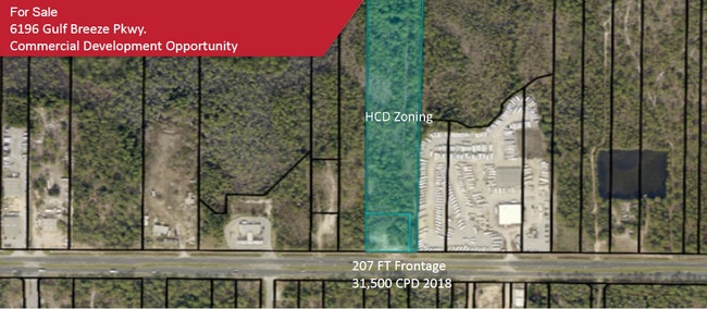
6214 Gulf Breeze Pkwy
21-2S-27-0000-01201-0000
COM NE CORN OF S2 OF NW4 THN N 88*4908W 1260.24 FT TO POB THN S0*0334W 1528.69 FT TO N R/W OF HWY 98 THN N89*2313W ON R/W 30 FT THN N0*0334E 200 FT THN N89*2313W 178.20 FT THN N0*2556W 1331.03 FT THN S88*4908E 219.65 FT TO POB LESS & EXCEPT PORT OF B
Commercialacreage
Santa Rosa
X
Florida
12113C0562H
6.49 AC
2024
Navarre
2025
Pensacola
010820
Pensacola-Ferry Pass-Brent, FL
DEMOGRAPHICS near 6214 Gulf Breeze Pkwy
1 Mile
3 Mile
5 Mile
2024 Total Population
5,266
21,909
40,871
2029 Population
6,171
25,413
47,302
Pop Growth 2024-2029
+ 17.19%
+ 15.99%
+ 15.73%
Average Age
40
40
40
2024 Total Households
2,022
8,194
15,482
HH Growth 2024-2029
+ 17.51%
+ 16.38%
+ 16.18%
Median Household Inc
$86,709
$92,050
$93,710
Avg Household Size
2.60
2.70
2.60
2024 Avg HH Vehicles
2.00
2.00
2.00
Median Home Value
$308,333
$318,718
$324,248
Median Year Built
2006
2005
2003
Nearby Places
- Restaurants
- Banks
- Shops
- Fitness
- Groceries
PUBLIC TRANSPORTATION
AIRPORT
Pensacola International
DRIVE
WALK
Distance
Pensacola International
42 min
23.6 mi
Eglin AFB/Destin-Ft Walton Beach
DRIVE
WALK
Distance
Eglin AFB/Destin-Ft Walton Beach
61 min
32.4 mi
Freight Ports
Port of Mobile
DRIVE
WALK
Distance
Port of Mobile
95 min
79.4 mi
SALE & LEASE HISTORY
LISTING DATE
SALE/LEASE

Nov 26, 2024
For Sale
Apr 07, 2020
For Sale
Nearby Properties
Address
Land Use
TOTAL SIZE
Lot Size
Zoning
Address
Land Use
TOTAL SIZE
Lot Size
Zoning
1.03 AC
NONE
Address
Land Use
TOTAL SIZE
Lot Size
Zoning
242,842 SF
14.77 AC
PBD
Address
Land Use
TOTAL SIZE
Lot Size
Zoning
241,693 SF
14.28 AC
PBD
Address
Land Use
TOTAL SIZE
Lot Size
Zoning
161,438 SF
5.64 AC
HCD
Address
Land Use
TOTAL SIZE
Lot Size
Zoning
68,134 SF
21.16 AC
R1
Address
Land Use
TOTAL SIZE
Lot Size
Zoning
116,452 SF
4.55 AC
HCD
Address
Land Use
TOTAL SIZE
Lot Size
Zoning
51,677 SF
17.79 AC
PBD
Address
Land Use
TOTAL SIZE
Lot Size
Zoning
19,350 SF
9.10 AC
HCD
Address
Land Use
TOTAL SIZE
Lot Size
Zoning
60,854 SF
7.07 AC
HCD
Address
Land Use
TOTAL SIZE
Lot Size
Zoning
130,030 SF
36.74 AC
R1A
Address
Land Use
TOTAL SIZE
Lot Size
Zoning
62,068 SF
4.64 AC
M1
Address
Land Use
TOTAL SIZE
Lot Size
Zoning
73,433 SF
33.98 AC
HCD
Address
Land Use
TOTAL SIZE
Lot Size
Zoning
24,565 SF
17.03 AC
HCD
Address
Land Use
TOTAL SIZE
Lot Size
Zoning
45,438 SF
4.85 AC
HCD
Address
Land Use
TOTAL SIZE
Lot Size
Zoning
25.10 AC
HCD
Address
Land Use
TOTAL SIZE
Lot Size
Zoning
62,960 SF
4.59 AC
HCD
Address
Land Use
TOTAL SIZE
Lot Size
Zoning
31,699 SF
4.39 AC
HCD
Address
Land Use
TOTAL SIZE
Lot Size
Zoning
48,285 SF
2.62 AC
HCD
Address
Land Use
TOTAL SIZE
Lot Size
Zoning
40,963 SF
8.36 AC
HCD
Address
Land Use
TOTAL SIZE
Lot Size
Zoning
22,042 SF
4.17 AC
HCD
Address
Land Use
TOTAL SIZE
Lot Size
Zoning
20.66 AC
PBD
Address
Land Use
TOTAL SIZE
Lot Size
Zoning
19.59 AC
HCD
Address
Land Use
TOTAL SIZE
Lot Size
Zoning
20,150 SF
4.02 AC
HCD
Address
Land Use
TOTAL SIZE
Lot Size
Zoning
17,056 SF
4.17 AC
HCD
Address
Land Use
TOTAL SIZE
Lot Size
Zoning
12.78 AC
HCD
Address
Land Use
TOTAL SIZE
Lot Size
Zoning
35,963 SF
19.17 AC
PBD
The World's #1 Commercial Real Estate Marketplace
Connect with us
© 2025 CoStar Group
The information above has been obtained from sources believed reliable. While we do not doubt its accuracy we have not verified it and make no guarantee, warranty or representation about it. It is your responsibility to independently confirm its accuracy and completeness. Any projections, opinions, assumptions, or estimates used are for example only and do not represent the current or future performance of the property. The value of this transaction to you depends on tax and other factors which should be evaluated by your tax, financial, and legal advisors. You and your advisors should conduct a careful, independent investigation of the property to determine to your satisfaction the suitability of the property for your needs.