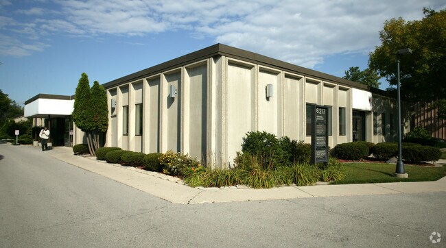
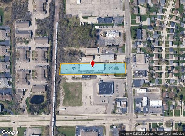
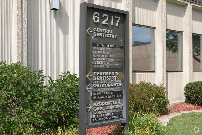
Property Record
6217 S Packard Ave, Cudahy, WI 53110
NEARBY LISTINGS FOR SALE OR LEASE
Property Detail
6217 S Packard Ave
682-9944-000
Metes & Bounds
Commercialnec
COM IN CL OF S PACKARD 440.31 FT NLY OF INTERSEC- TION WITH S LI SW 35 6 22 TH W PAR TO S LI SD QTR SEC 659.25 FT TO ELY LI CNWRY ROW TH NLY ALG SD ROW LI 102.84 FT TH E 651.76 FT TO CL OF S PACKARD TH SLY 102.84 FT TO BEG EXC E 40 FT FOR STREET
X
Milwaukee
55079C0186E
Wisconsin
2024
1.45 AC
2024
Milwaukee SE
180400
Milwaukee/Madison
16,416 SF
Milwaukee-Waukesha-West Allis, WI
DEMOGRAPHICS near 6217 S Packard Ave
1 Mile
3 Mile
5 Mile
2024 Total Population
11,083
49,757
126,798
2029 Population
10,774
48,287
123,391
Pop Growth 2024-2029
(2.79%)
(2.95%)
(2.69%)
Average Age
44
42
41
2024 Total Households
5,134
22,279
55,467
HH Growth 2024-2029
(2.88%)
(3.01%)
(2.73%)
Median Household Inc
$63,416
$65,277
$67,521
Avg Household Size
2.10
2.20
2.20
2024 Avg HH Vehicles
2.00
2.00
2.00
Median Home Value
$188,964
$196,731
$207,803
Median Year Built
1964
1960
1961
Nearby Places
Map Layers
Map Styles
 Street
 Aerial
- Restaurants
- Banks
- Shops
- Fitness
- Groceries
PUBLIC TRANSPORTATION
COMMUTER RAIL
DRIVE
WALK
Distance
11 min
4.3 mi
DRIVE
WALK
Distance
18 min
9.7 mi
AIRPORT
General Mitchell International
DRIVE
WALK
Distance
General Mitchell International
10 min
4.5 mi
Freight Ports
Port Milwaukee
DRIVE
WALK
Distance
Port Milwaukee
15 min
7.1 mi
Nearby Properties
Address
Land Use
TOTAL SIZE
Lot Size
Zoning
Address
Land Use
TOTAL SIZE
Lot Size
Zoning
Address
Land Use
TOTAL SIZE
Lot Size
Zoning
11.09 AC
Address
Land Use
TOTAL SIZE
Lot Size
Zoning
27.30 AC
RESIDENTIA
Address
Land Use
TOTAL SIZE
Lot Size
Zoning
26.21 AC
Address
Land Use
TOTAL SIZE
Lot Size
Zoning
9.24 AC
RESIDENTIA
Address
Land Use
TOTAL SIZE
Lot Size
Zoning
378,000 SF
19.24 AC
M-1PUD
Address
Land Use
TOTAL SIZE
Lot Size
Zoning
94.05 AC
PK
Address
Land Use
TOTAL SIZE
Lot Size
Zoning
153,300 SF
7.39 AC
M-1PUD
Address
Land Use
TOTAL SIZE
Lot Size
Zoning
85,264 SF
3.67 AC
PD
Address
Land Use
TOTAL SIZE
Lot Size
Zoning
216,281 SF
5.99 AC
RESIDENTIA
Address
Land Use
TOTAL SIZE
Lot Size
Zoning
Address
Land Use
TOTAL SIZE
Lot Size
Zoning
Address
Land Use
TOTAL SIZE
Lot Size
Zoning
Address
Land Use
TOTAL SIZE
Lot Size
Zoning
Address
Land Use
TOTAL SIZE
Lot Size
Zoning
Address
Land Use
TOTAL SIZE
Lot Size
Zoning
Address
Land Use
TOTAL SIZE
Lot Size
Zoning
Address
Land Use
TOTAL SIZE
Lot Size
Zoning
1,125 SF
13.50 AC
Address
Land Use
TOTAL SIZE
Lot Size
Zoning
153,000 SF
8.22 AC
M-1PUD
Address
Land Use
TOTAL SIZE
Lot Size
Zoning
149,489 SF
7.43 AC
M-1PUD
Address
Land Use
TOTAL SIZE
Lot Size
Zoning
142,210 SF
14.70 AC
M-1PUD
Address
Land Use
TOTAL SIZE
Lot Size
Zoning
Address
Land Use
TOTAL SIZE
Lot Size
Zoning
36.60 AC
Address
Land Use
TOTAL SIZE
Lot Size
Zoning
405,764 SF
12.70 AC
M-2
Address
Land Use
TOTAL SIZE
Lot Size
Zoning
9,647 SF
7.82 AC
RESIDENTIA
Address
Land Use
TOTAL SIZE
Lot Size
Zoning
169,128 SF
8.92 AC
M-1PUD
Address
Land Use
TOTAL SIZE
Lot Size
Zoning
Address
Land Use
TOTAL SIZE
Lot Size
Zoning
126,791 SF
8.81 AC
RESIDENTIA
Address
Land Use
TOTAL SIZE
Lot Size
Zoning
118,320 SF
6.29 AC
M-1PUD
Address
Land Use
TOTAL SIZE
Lot Size
Zoning
9.58 AC
The World's #1 Commercial Real Estate Marketplace
Connect with us
© 2025 CoStar Group
The information above has been obtained from sources believed reliable. While we do not doubt its accuracy we have not verified it and make no guarantee, warranty or representation about it. It is your responsibility to independently confirm its accuracy and completeness. Any projections, opinions, assumptions, or estimates used are for example only and do not represent the current or future performance of the property. The value of this transaction to you depends on tax and other factors which should be evaluated by your tax, financial, and legal advisors. You and your advisors should conduct a careful, independent investigation of the property to determine to your satisfaction the suitability of the property for your needs.