Property Record
6218 S 27Th St, Milwaukee, WI 53221


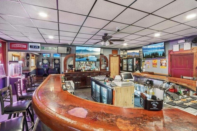
This Property Is For Sale
NEARBY LISTINGS FOR SALE OR LEASE
Property Detail
6218 S 27Th St
690-9880-100-6
Mangold Gardens Subdivision No 4
Bartavern
LANDS IN SW 1/4 SEC 31-6-22 COM W LI & 1969.63 S OF NW COR SD 1/4 SEC-TH S 110-TH E 343-TH N 110-TH W 343 TO BEG EXC W 80 FOR ST BID #43
X
Milwaukee
55079C0162E
Wisconsin
2024
0.66 AC
2024
Milwaukee Near SW
021700
Milwaukee/Madison
3,399 SF
Milwaukee-Waukesha-West Allis, WI
DEMOGRAPHICS near 6218 S 27Th St
1 Mile
3 Mile
5 Mile
2024 Total Population
13,200
68,071
240,193
2029 Population
13,119
67,696
237,052
Pop Growth 2024-2029
(0.61%)
(0.55%)
(1.31%)
Average Age
41
41
40
2024 Total Households
5,353
28,189
100,196
HH Growth 2024-2029
(0.71%)
(0.62%)
(1.31%)
Median Household Inc
$75,781
$79,931
$77,160
Avg Household Size
2.40
2.30
2.30
2024 Avg HH Vehicles
2.00
2.00
2.00
Median Home Value
$253,200
$266,597
$249,290
Median Year Built
1972
1971
1964
Nearby Places
Map Layers
Map Styles
 Street
 Aerial
- Restaurants
- Banks
- Shops
- Fitness
- Groceries
PUBLIC TRANSPORTATION
COMMUTER RAIL
General Mitchell Intl. Airport Amtrak Station (Hiawatha Service - Amtrak)
DRIVE
WALK
Distance
General Mitchell Intl. Airport Amtrak Station (Hiawatha Service - Amtrak)
7 min
2.8 mi
Milwaukee (Empire Builder - Amtrak)
DRIVE
WALK
Distance
Milwaukee (Empire Builder - Amtrak)
14 min
9.3 mi
AIRPORT
General Mitchell International
DRIVE
WALK
Distance
General Mitchell International
8 min
3.8 mi
Freight Ports
Port Milwaukee
DRIVE
WALK
Distance
Port Milwaukee
12 min
7.2 mi
Nearby Properties
Address
Land Use
TOTAL SIZE
Lot Size
Zoning
Address
Land Use
TOTAL SIZE
Lot Size
Zoning
Address
Land Use
TOTAL SIZE
Lot Size
Zoning
19.92 AC
Address
Land Use
TOTAL SIZE
Lot Size
Zoning
33.80 AC
Address
Land Use
TOTAL SIZE
Lot Size
Zoning
28.76 AC
Address
Land Use
TOTAL SIZE
Lot Size
Zoning
3.15 AC
Address
Land Use
TOTAL SIZE
Lot Size
Zoning
6.90 AC
Address
Land Use
TOTAL SIZE
Lot Size
Zoning
Address
Land Use
TOTAL SIZE
Lot Size
Zoning
16.06 AC
Address
Land Use
TOTAL SIZE
Lot Size
Zoning
3.45 AC
Address
Land Use
TOTAL SIZE
Lot Size
Zoning
2.53 AC
Address
Land Use
TOTAL SIZE
Lot Size
Zoning
23.09 AC
Address
Land Use
TOTAL SIZE
Lot Size
Zoning
63,273 SF
5.42 AC
Address
Land Use
TOTAL SIZE
Lot Size
Zoning
188,328 SF
22.41 AC
PD
Address
Land Use
TOTAL SIZE
Lot Size
Zoning
17.47 AC
R2
Address
Land Use
TOTAL SIZE
Lot Size
Zoning
Address
Land Use
TOTAL SIZE
Lot Size
Zoning
8.79 AC
RESIDENTIA
Address
Land Use
TOTAL SIZE
Lot Size
Zoning
238,201 SF
17.96 AC
PUDR5
Address
Land Use
TOTAL SIZE
Lot Size
Zoning
26.21 AC
Address
Land Use
TOTAL SIZE
Lot Size
Zoning
21.72 AC
RESIDENTIA
Address
Land Use
TOTAL SIZE
Lot Size
Zoning
162,138 SF
9.15 AC
PD
Address
Land Use
TOTAL SIZE
Lot Size
Zoning
213,964 SF
13.94 AC
PUDR5
Address
Land Use
TOTAL SIZE
Lot Size
Zoning
16.48 AC
Address
Land Use
TOTAL SIZE
Lot Size
Zoning
13.84 AC
Address
Land Use
TOTAL SIZE
Lot Size
Zoning
360,000 SF
14.60 AC
IL1
Address
Land Use
TOTAL SIZE
Lot Size
Zoning
4.27 AC
Address
Land Use
TOTAL SIZE
Lot Size
Zoning
15.78 AC
Address
Land Use
TOTAL SIZE
Lot Size
Zoning
15.92 AC
Address
Land Use
TOTAL SIZE
Lot Size
Zoning
152,130 SF
7.68 AC
PD
Address
Land Use
TOTAL SIZE
Lot Size
Zoning
Address
Land Use
TOTAL SIZE
Lot Size
Zoning
130,723 SF
12.94 AC
C2
The World's #1 Commercial Real Estate Marketplace
Connect with us
© 2026 CoStar Group
The information above has been obtained from sources believed reliable. While we do not doubt its accuracy we have not verified it and make no guarantee, warranty or representation about it. It is your responsibility to independently confirm its accuracy and completeness. Any projections, opinions, assumptions, or estimates used are for example only and do not represent the current or future performance of the property. The value of this transaction to you depends on tax and other factors which should be evaluated by your tax, financial, and legal advisors. You and your advisors should conduct a careful, independent investigation of the property to determine to your satisfaction the suitability of the property for your needs.