Property Record
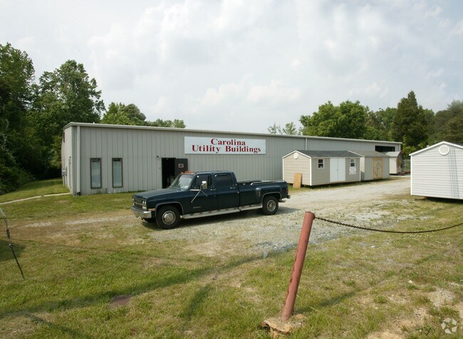
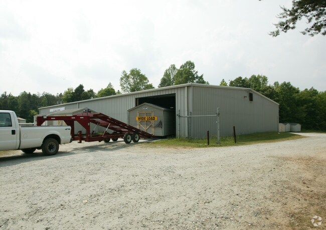
6219 Nc Highway 62, Trinity, NC 27370

Property Detail
6219 Nc Highway 62
7707-27-7415
R62;R1882
Warehouse
Randolph
UR
North Carolina
AE The base floodplain where base flood elevations are provided. AE Zones are now used on new format FIRMs instead of A1-A30 Zones.
7.11 AC
2025
NW Randolph Cnty/Archdale
2025
Greensboro/Winston-Salem
031601
Greensboro-High Point, NC
10,000 SF
NEARBY LISTINGS FOR SALE OR LEASE
DEMOGRAPHICS near 6219 Nc Highway 62
1 mile
3 mile
5 mile
2025 Total Population
1,161
15,283
69,193
2030 Population
1,193
15,635
71,690
Pop Growth 2025-2030
+ 2.76%
+ 2.30%
+ 3.61%
Average Age
44
43
40
2025 Total Households
470
6,331
27,523
HH Growth 2025-2030
+ 2.77%
+ 2.32%
+ 3.67%
Median Household Inc
$74,094
$64,944
$58,202
Avg Household Size
2.40
2.40
2.40
2025 Avg HH Vehicles
2.00
2.00
2.00
Median Home Value
$232,624
$212,474
$196,125
Median Year Built
1982
1982
1978
Nearby Places
Map Layers
Map Styles
 Street
 Aerial
Layers
 Traffic
 Biking
Places
Listings with unknown addresses are not visible on the map
- Restaurants
- Banks
- Shops
- Fitness
- Groceries
PUBLIC TRANSPORTATION
COMMUTER RAIL
High Point Station (Piedmont - North Carolina by Train (NC Train))
Drive
Walk
Distance
High Point Station (Piedmont - North Carolina by Train (NC Train))
13 min
6.5 mi
AIRPORT
Piedmont Triad International
Drive
Walk
Distance
Piedmont Triad International
36 min
21.8 mi
Nearby Properties
Address
Land Use
TOTAL SIZE
Lot Size
Zoning
Address
Land Use
TOTAL SIZE
Lot Size
Zoning
154,870 SF
62.93 AC
M1
Address
Land Use
TOTAL SIZE
Lot Size
Zoning
355,633 SF
63.42 AC
HI
Address
Land Use
TOTAL SIZE
Lot Size
Zoning
204,276 SF
68.51 AC
M-2
Address
Land Use
TOTAL SIZE
Lot Size
Zoning
156,010 SF
36.21 AC
M-1
Address
Land Use
TOTAL SIZE
Lot Size
Zoning
127,800 SF
57.35 AC
M-1
Address
Land Use
TOTAL SIZE
Lot Size
Zoning
245,194 SF
23.44 AC
LI
Address
Land Use
TOTAL SIZE
Lot Size
Zoning
166.25 AC
CD R-10
Address
Land Use
TOTAL SIZE
Lot Size
Zoning
27,310 SF
20.06 AC
HI
Address
Land Use
TOTAL SIZE
Lot Size
Zoning
109,950 SF
28.29 AC
M-1
Address
Land Use
TOTAL SIZE
Lot Size
Zoning
28.20 AC
RR
Address
Land Use
TOTAL SIZE
Lot Size
Zoning
60,183 SF
8.63 AC
C-2
Address
Land Use
TOTAL SIZE
Lot Size
Zoning
127,280 SF
29.10 AC
LI-CZ
Address
Land Use
TOTAL SIZE
Lot Size
Zoning
45,224 SF
8.03 AC
OI
Address
Land Use
TOTAL SIZE
Lot Size
Zoning
104,623 SF
55.13 AC
RR
Address
Land Use
TOTAL SIZE
Lot Size
Zoning
234,080 SF
14.88 AC
HI
Address
Land Use
TOTAL SIZE
Lot Size
Zoning
9.70 AC
RR
Address
Land Use
TOTAL SIZE
Lot Size
Zoning
99,649 SF
15.58 AC
HI
Address
Land Use
TOTAL SIZE
Lot Size
Zoning
240,510 SF
3.76 AC
LI
Address
Land Use
TOTAL SIZE
Lot Size
Zoning
246,972 SF
19.83 AC
HI
Address
Land Use
TOTAL SIZE
Lot Size
Zoning
8,927 SF
3.60 AC
OI
Address
Land Use
TOTAL SIZE
Lot Size
Zoning
42,262 SF
6.73 AC
M1
Address
Land Use
TOTAL SIZE
Lot Size
Zoning
114,220 SF
69.22 AC
M1
Address
Land Use
TOTAL SIZE
Lot Size
Zoning
99,722 SF
38.11 AC
M-2
Address
Land Use
TOTAL SIZE
Lot Size
Zoning
202,416 SF
11.45 AC
M-1
Address
Land Use
TOTAL SIZE
Lot Size
Zoning
7,808 SF
6.41 AC
HI
Address
Land Use
TOTAL SIZE
Lot Size
Zoning
37,680 SF
1.66 AC
CD HB
Address
Land Use
TOTAL SIZE
Lot Size
Zoning
15,522 SF
167.47 AC
RR
Address
Land Use
TOTAL SIZE
Lot Size
Zoning
18.23 AC
R-15
Address
Land Use
TOTAL SIZE
Lot Size
Zoning
5,280 SF
16.74 AC
RA
Address
Land Use
TOTAL SIZE
Lot Size
Zoning
12,288 SF
4.10 AC
O&I-CZ
The World's #1 Commercial Real Estate Marketplace
Connect with us
© 2026 CoStar Group
The information above has been obtained from sources believed reliable. While we do not doubt its accuracy we have not verified it and make no guarantee, warranty or representation about it. It is your responsibility to independently confirm its accuracy and completeness. Any projections, opinions, assumptions, or estimates used are for example only and do not represent the current or future performance of the property. The value of this transaction to you depends on tax and other factors which should be evaluated by your tax, financial, and legal advisors. You and your advisors should conduct a careful, independent investigation of the property to determine to your satisfaction the suitability of the property for your needs.