Property Record
622 Hugh Adams Rd, Defuniak Springs, FL 32435

NEARBY LISTINGS FOR SALE OR LEASE
Property Detail
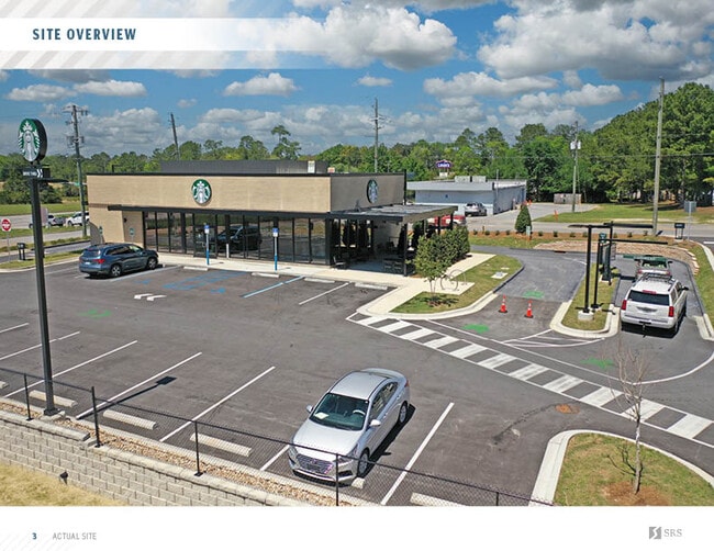
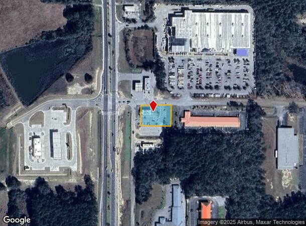
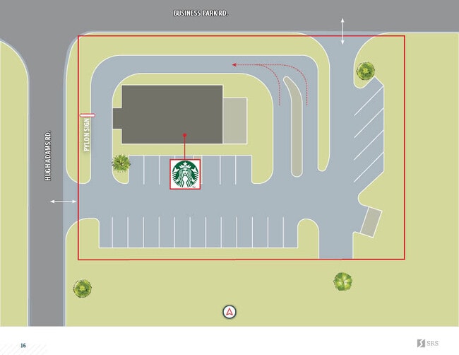
622 Hugh Adams Rd
Crestview-Fort Walton Beach-Destin, FL
Business Park
02-2N-19-18000-046-0010
COM INTERSECTION E ROW US HWY 331 & S ROW BUSINESS PARK RD FOR POB; ALG S ROW BUSSINESS PARK RD S 88 DEG 3524E 200.01 FT, DPRT ROW S 01 DEG 2151W 134.33FT, N 88 DEG 3523W 199.90FT TO E ROW US HWY 331, ALG ROW N 01 DEG 1905E 134.33FT TO POB. OR 883-17
Restaurantdrivein
Walton
X
Florida
12131C0280G
10
2025
0.62 AC
2025
Florida Panhandle Area
950201
Other Market Areas
3,308 SF
DEMOGRAPHICS near 622 Hugh Adams Rd
1 Mile
3 Mile
5 Mile
2024 Total Population
356
5,266
10,804
2029 Population
426
6,274
12,945
Pop Growth 2024-2029
+ 19.66%
+ 19.14%
+ 19.82%
Average Age
41
39
39
2024 Total Households
123
1,789
3,534
HH Growth 2024-2029
+ 18.70%
+ 18.89%
+ 19.75%
Median Household Inc
$43,181
$39,681
$39,540
Avg Household Size
2.50
2.40
2.50
2024 Avg HH Vehicles
2.00
2.00
2.00
Median Home Value
$84,313
$98,086
$97,463
Median Year Built
1983
1986
1990
Nearby Places
Map Layers
Map Styles
 Street
 Aerial
- Restaurants
- Banks
- Shops
- Fitness
- Groceries
PUBLIC TRANSPORTATION
AIRPORT
Eglin AFB/Destin-Ft Walton Beach
DRIVE
WALK
Distance
Eglin AFB/Destin-Ft Walton Beach
66 min
38.5 mi
Northwest Florida Beaches International
DRIVE
WALK
Distance
Northwest Florida Beaches International
60 min
45.1 mi
Freight Ports
Port of Panama City
DRIVE
WALK
Distance
Port of Panama City
77 min
55.7 mi
SALE & LEASE HISTORY
LISTING DATE
SALE/LEASE

Sep 25, 2020
For Sale
Sep 14, 2022
For Sale
Apr 17, 2023
For Sale
Nearby Properties
Address
Land Use
TOTAL SIZE
Lot Size
Zoning
Address
Land Use
TOTAL SIZE
Lot Size
Zoning
174,929 SF
9.32 AC
HD1
Address
Land Use
TOTAL SIZE
Lot Size
Zoning
41,056 SF
2.22 AC
3310
Address
Land Use
TOTAL SIZE
Lot Size
Zoning
96,057 SF
10.37 AC
W END
Address
Land Use
TOTAL SIZE
Lot Size
Zoning
54,534 SF
7.33 AC
MUNI
Address
Land Use
TOTAL SIZE
Lot Size
Zoning
160,339 SF
19.76 AC
3310
Address
Land Use
TOTAL SIZE
Lot Size
Zoning
37,731 SF
15.96 AC
Address
Land Use
TOTAL SIZE
Lot Size
Zoning
53,201 SF
14.45 AC
Address
Land Use
TOTAL SIZE
Lot Size
Zoning
101,840 SF
11.04 AC
3310
Address
Land Use
TOTAL SIZE
Lot Size
Zoning
126,076 SF
11.38 AC
3310
Address
Land Use
TOTAL SIZE
Lot Size
Zoning
10,655 SF
163.72 AC
MUNI
Address
Land Use
TOTAL SIZE
Lot Size
Zoning
3,729 SF
98.46 AC
MUNI
Address
Land Use
TOTAL SIZE
Lot Size
Zoning
109,921 SF
2.25 AC
Address
Land Use
TOTAL SIZE
Lot Size
Zoning
52,428 SF
4.66 AC
3310
Address
Land Use
TOTAL SIZE
Lot Size
Zoning
68,153 SF
9.65 AC
3310
Address
Land Use
TOTAL SIZE
Lot Size
Zoning
44,789 SF
4.34 AC
Address
Land Use
TOTAL SIZE
Lot Size
Zoning
61,948 SF
9.26 AC
3310
Address
Land Use
TOTAL SIZE
Lot Size
Zoning
15,264 SF
3.24 AC
3310
Address
Land Use
TOTAL SIZE
Lot Size
Zoning
15,587 SF
5.54 AC
Address
Land Use
TOTAL SIZE
Lot Size
Zoning
5,951 SF
1.64 AC
3310
Address
Land Use
TOTAL SIZE
Lot Size
Zoning
48,394 SF
8.79 AC
3310
Address
Land Use
TOTAL SIZE
Lot Size
Zoning
Address
Land Use
TOTAL SIZE
Lot Size
Zoning
70,200 SF
5.25 AC
3310
Address
Land Use
TOTAL SIZE
Lot Size
Zoning
104,680 SF
10 AC
Address
Land Use
TOTAL SIZE
Lot Size
Zoning
13,793 SF
2.80 AC
3310
Address
Land Use
TOTAL SIZE
Lot Size
Zoning
23,674 SF
12.03 AC
3310
Address
Land Use
TOTAL SIZE
Lot Size
Zoning
32,375 SF
6.46 AC
HWY90
Address
Land Use
TOTAL SIZE
Lot Size
Zoning
17,310 SF
13.26 AC
3310
Address
Land Use
TOTAL SIZE
Lot Size
Zoning
35,967 SF
4.11 AC
Address
Land Use
TOTAL SIZE
Lot Size
Zoning
14,525 SF
0.90 AC
HWY90
Address
Land Use
TOTAL SIZE
Lot Size
Zoning
17,376 SF
79.90 AC
HD1
The World's #1 Commercial Real Estate Marketplace
Connect with us
© 2026 CoStar Group
The information above has been obtained from sources believed reliable. While we do not doubt its accuracy we have not verified it and make no guarantee, warranty or representation about it. It is your responsibility to independently confirm its accuracy and completeness. Any projections, opinions, assumptions, or estimates used are for example only and do not represent the current or future performance of the property. The value of this transaction to you depends on tax and other factors which should be evaluated by your tax, financial, and legal advisors. You and your advisors should conduct a careful, independent investigation of the property to determine to your satisfaction the suitability of the property for your needs.