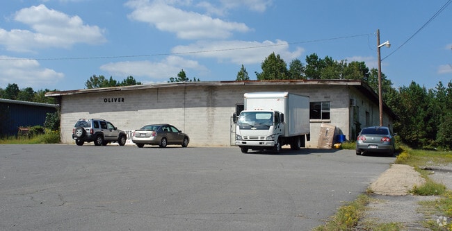
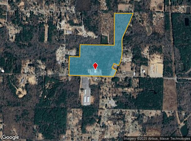
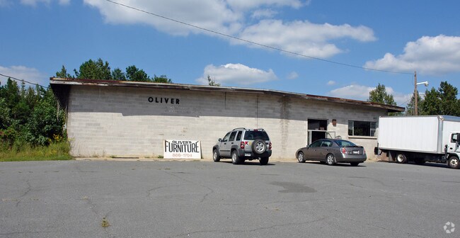
Property Record
622 Pratt Rd, Little Rock, AR 72206
NEARBY LISTINGS FOR SALE OR LEASE
Property Detail
622 Pratt Rd
35R-022-00-002-00
PT NE SECTION 22-1S-12 LYING WEST OF OLD SHERIDAN ROAD (IRONTON ROAD) BEG 30'N OF SW COR ON NLN PRATT ROAD N ON WLN 1288.33' TO NW COR SW NE TH S88*57'E ON NLN 1306.67' TO SW COR NE NE N1292' TO SLN ROAD TH E ON ROAD TO W
Warehouse
Pulaski
AE
Arkansas
05125C0425E
71.68 AC
2025
Outlying Pulaski County
2025
Little Rock/N Little Rock
004006
Little Rock-North Little Rock-Conway, AR
34,500 SF
DEMOGRAPHICS near 622 Pratt Rd
1 Mile
3 Mile
5 Mile
2024 Total Population
919
6,790
28,735
2029 Population
939
6,898
29,356
Pop Growth 2024-2029
+ 2.18%
+ 1.59%
+ 2.16%
Average Age
45
43
38
2024 Total Households
381
2,760
10,987
HH Growth 2024-2029
+ 2.10%
+ 1.59%
+ 2.18%
Median Household Inc
$37,843
$44,597
$49,307
Avg Household Size
2.40
2.40
2.50
2024 Avg HH Vehicles
2.00
2.00
2.00
Median Home Value
$139,285
$133,619
$127,042
Median Year Built
1984
1979
1978
Nearby Places
Map Layers
Map Styles
 Street
 Aerial
- Restaurants
- Banks
- Shops
- Fitness
- Groceries
PUBLIC TRANSPORTATION
AIRPORT
Bill and Hillary Clinton Ntl/Adams Field
DRIVE
WALK
Distance
Bill and Hillary Clinton Ntl/Adams Field
16 min
11.2 mi
Nearby Properties
Address
Land Use
TOTAL SIZE
Lot Size
Zoning
Address
Land Use
TOTAL SIZE
Lot Size
Zoning
70,281 SF
20.36 AC
Address
Land Use
TOTAL SIZE
Lot Size
Zoning
Address
Land Use
TOTAL SIZE
Lot Size
Zoning
57,396 SF
10.92 AC
Address
Land Use
TOTAL SIZE
Lot Size
Zoning
38,125 SF
23.40 AC
Address
Land Use
TOTAL SIZE
Lot Size
Zoning
600 SF
0.23 AC
Address
Land Use
TOTAL SIZE
Lot Size
Zoning
9,235 SF
10.93 AC
Address
Land Use
TOTAL SIZE
Lot Size
Zoning
30,261 SF
70 AC
Address
Land Use
TOTAL SIZE
Lot Size
Zoning
4,487 SF
39.87 AC
Address
Land Use
TOTAL SIZE
Lot Size
Zoning
77.68 AC
Address
Land Use
TOTAL SIZE
Lot Size
Zoning
48,000 SF
11.67 AC
Address
Land Use
TOTAL SIZE
Lot Size
Zoning
23,200 SF
33.98 AC
Address
Land Use
TOTAL SIZE
Lot Size
Zoning
57.36 AC
Address
Land Use
TOTAL SIZE
Lot Size
Zoning
19,306 SF
20 AC
Address
Land Use
TOTAL SIZE
Lot Size
Zoning
375 SF
4.24 AC
Address
Land Use
TOTAL SIZE
Lot Size
Zoning
2,341 SF
2 AC
Address
Land Use
TOTAL SIZE
Lot Size
Zoning
Address
Land Use
TOTAL SIZE
Lot Size
Zoning
24,800 SF
13.07 AC
Address
Land Use
TOTAL SIZE
Lot Size
Zoning
Address
Land Use
TOTAL SIZE
Lot Size
Zoning
15,312 SF
1.61 AC
Address
Land Use
TOTAL SIZE
Lot Size
Zoning
Address
Land Use
TOTAL SIZE
Lot Size
Zoning
3,113 SF
1.96 AC
Address
Land Use
TOTAL SIZE
Lot Size
Zoning
12.86 AC
Address
Land Use
TOTAL SIZE
Lot Size
Zoning
9,900 SF
4.57 AC
Address
Land Use
TOTAL SIZE
Lot Size
Zoning
25,466 SF
8 AC
Address
Land Use
TOTAL SIZE
Lot Size
Zoning
39,478 SF
7.27 AC
Address
Land Use
TOTAL SIZE
Lot Size
Zoning
50,000 SF
6.05 AC
Address
Land Use
TOTAL SIZE
Lot Size
Zoning
5,748 SF
14.91 AC
Address
Land Use
TOTAL SIZE
Lot Size
Zoning
22,566 SF
5.45 AC
Address
Land Use
TOTAL SIZE
Lot Size
Zoning
48,000 SF
11.80 AC
The World's #1 Commercial Real Estate Marketplace
Connect with us
© 2025 CoStar Group
The information above has been obtained from sources believed reliable. While we do not doubt its accuracy we have not verified it and make no guarantee, warranty or representation about it. It is your responsibility to independently confirm its accuracy and completeness. Any projections, opinions, assumptions, or estimates used are for example only and do not represent the current or future performance of the property. The value of this transaction to you depends on tax and other factors which should be evaluated by your tax, financial, and legal advisors. You and your advisors should conduct a careful, independent investigation of the property to determine to your satisfaction the suitability of the property for your needs.