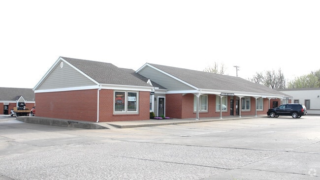
Property Record
615 Sw 2Nd St, Lees Summit, MO 64063

NEARBY LISTINGS FOR SALE OR LEASE
Property Detail
615 Sw 2Nd St
61-330-16-89-00-0-00-000
RNG-31 TWP-47 SEC-06 PT SW 1/4 DAF: BEG AT A PT 1150 W OF S E COR SD SW 1/4 TH N 28 M/L TO N ROW LI OF 3RD ST & TRU POB TH CONT N 220 TH E 130 TO SW COR LOT 58 ROBIN HILLS TH N
Regionalshoppingcenterormallwithanchorstore
Jackson
X
Missouri
29095C0417G
58
2024
6.43 AC
2025
Southeast Jackson County
018000
Kansas City
55,212 SF
Kansas City, MO-KS
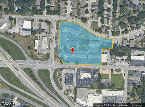
DEMOGRAPHICS near 615 Sw 2Nd St
1 Mile
3 Mile
5 Mile
2024 Total Population
8,420
52,008
89,725
2029 Population
8,315
51,743
89,361
Pop Growth 2024-2029
(1.25%)
(0.51%)
(0.41%)
Average Age
42
41
40
2024 Total Households
3,761
21,012
34,272
HH Growth 2024-2029
(1.28%)
(0.49%)
(0.44%)
Median Household Inc
$66,388
$88,158
$97,715
Avg Household Size
2.20
2.40
2.60
2024 Avg HH Vehicles
2.00
2.00
2.00
Median Home Value
$212,222
$256,423
$276,681
Median Year Built
1971
1987
1991
Nearby Places
Map Layers
Map Styles
 Street
 Aerial
- Restaurants
- Banks
- Shops
- Fitness
- Groceries
PUBLIC TRANSPORTATION
COMMUTER RAIL
Lee's Summit Amtrak (Lincoln Service Missouri River Runner - Amtrak, Missouri River Runner - Amtrak)
DRIVE
WALK
Distance
Lee's Summit Amtrak (Lincoln Service Missouri River Runner - Amtrak, Missouri River Runner - Amtrak)
2 min
16 min
0.9 mi
Freight Ports
Tulsa Port Of Catoosa
DRIVE
WALK
Distance
Tulsa Port Of Catoosa
260 min
237.9 mi
SALE & LEASE HISTORY
LISTING DATE
SALE/LEASE

Mar 31, 2017
For Lease
Jun 25, 2025
For Lease
Feb 23, 2022
For Lease
Apr 28, 2023
For Lease
Nearby Properties
Address
Land Use
TOTAL SIZE
Lot Size
Zoning
Address
Land Use
TOTAL SIZE
Lot Size
Zoning
474,121 SF
40.14 AC
Address
Land Use
TOTAL SIZE
Lot Size
Zoning
535,500 SF
54.13 AC
Address
Land Use
TOTAL SIZE
Lot Size
Zoning
480,000 SF
45.89 AC
Address
Land Use
TOTAL SIZE
Lot Size
Zoning
246,379 SF
51.99 AC
Address
Land Use
TOTAL SIZE
Lot Size
Zoning
438,125 SF
Address
Land Use
TOTAL SIZE
Lot Size
Zoning
107,210 SF
17.13 AC
Address
Land Use
TOTAL SIZE
Lot Size
Zoning
249,821 SF
87.90 AC
Address
Land Use
TOTAL SIZE
Lot Size
Zoning
246,384 SF
22 AC
Address
Land Use
TOTAL SIZE
Lot Size
Zoning
209,098 SF
Address
Land Use
TOTAL SIZE
Lot Size
Zoning
339,970 SF
Address
Land Use
TOTAL SIZE
Lot Size
Zoning
52,030 SF
11.81 AC
Address
Land Use
TOTAL SIZE
Lot Size
Zoning
227,052 SF
12.78 AC
Address
Land Use
TOTAL SIZE
Lot Size
Zoning
100,573 SF
2.89 AC
Address
Land Use
TOTAL SIZE
Lot Size
Zoning
104,368 SF
13.90 AC
Address
Land Use
TOTAL SIZE
Lot Size
Zoning
248,600 SF
Address
Land Use
TOTAL SIZE
Lot Size
Zoning
383,280 SF
0.91 AC
Address
Land Use
TOTAL SIZE
Lot Size
Zoning
140,377 SF
27 AC
Address
Land Use
TOTAL SIZE
Lot Size
Zoning
563,000 SF
40.34 AC
Address
Land Use
TOTAL SIZE
Lot Size
Zoning
165,827 SF
14.49 AC
Address
Land Use
TOTAL SIZE
Lot Size
Zoning
72,168 SF
Address
Land Use
TOTAL SIZE
Lot Size
Zoning
195,586 SF
20.91 AC
Address
Land Use
TOTAL SIZE
Lot Size
Zoning
184,445 SF
Address
Land Use
TOTAL SIZE
Lot Size
Zoning
136,224 SF
15.25 AC
Address
Land Use
TOTAL SIZE
Lot Size
Zoning
104,704 SF
11.28 AC
Address
Land Use
TOTAL SIZE
Lot Size
Zoning
126,081 SF
21 AC
Address
Land Use
TOTAL SIZE
Lot Size
Zoning
192,014 SF
20.95 AC
Address
Land Use
TOTAL SIZE
Lot Size
Zoning
82,704 SF
148.69 AC
Address
Land Use
TOTAL SIZE
Lot Size
Zoning
125,609 SF
9.32 AC
Address
Land Use
TOTAL SIZE
Lot Size
Zoning
59,820 SF
6.22 AC
Address
Land Use
TOTAL SIZE
Lot Size
Zoning
74,771 SF
6.88 AC
The World's #1 Commercial Real Estate Marketplace
Connect with us
© 2025 CoStar Group
The information above has been obtained from sources believed reliable. While we do not doubt its accuracy we have not verified it and make no guarantee, warranty or representation about it. It is your responsibility to independently confirm its accuracy and completeness. Any projections, opinions, assumptions, or estimates used are for example only and do not represent the current or future performance of the property. The value of this transaction to you depends on tax and other factors which should be evaluated by your tax, financial, and legal advisors. You and your advisors should conduct a careful, independent investigation of the property to determine to your satisfaction the suitability of the property for your needs.