Property Record
6220 Highway 2 E, Minot, ND 58701

NEARBY LISTINGS FOR SALE OR LEASE
-
-
View all Minot listings for lease on LoopNet.com
Property Detail
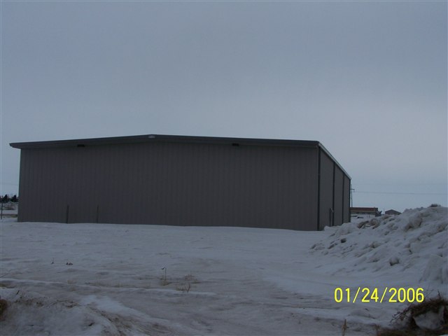
6220 Highway 2 E
Other Market Areas
T U R Add
Minot, ND
Ward
NE-22032-000-020-2
North Dakota
Singlefamilyresidentialassumed
1.23 AC
7,560 SF
North Dakota Area
DEMOGRAPHICS near 6220 Highway 2 E
1 Mile
3 Mile
5 Mile
2024 Total Population
874
5,203
29,921
2029 Population
856
5,116
29,484
Pop Growth 2024-2029
(2.06%)
(1.67%)
(1.46%)
Average Age
37
37
38
2024 Total Households
346
2,045
12,635
HH Growth 2024-2029
(2.02%)
(1.66%)
(1.50%)
Median Household Inc
$101,607
$72,275
$67,342
Avg Household Size
2.50
2.50
2.20
2024 Avg HH Vehicles
2.00
2.00
2.00
Median Home Value
$300,521
$254,851
$228,396
Median Year Built
2003
1991
1978
Nearby Places
Map Layers
Map Styles
 Street
 Aerial
- Restaurants
- Banks
- Shops
- Fitness
- Groceries
PUBLIC TRANSPORTATION
COMMUTER RAIL
DRIVE
WALK
Distance
9 min
5.1 mi
AIRPORT
Minot International
DRIVE
WALK
Distance
Minot International
14 min
6.4 mi
SALE & LEASE HISTORY
LISTING DATE
SALE/LEASE

Nov 22, 2024
For Lease
Feb 24, 2020
For Sale
Nearby Properties
Address
Land Use
TOTAL SIZE
Lot Size
Zoning
Address
Land Use
TOTAL SIZE
Lot Size
Zoning
43,940 SF
20.79 AC
Address
Land Use
TOTAL SIZE
Lot Size
Zoning
4,000 SF
59.25 AC
Address
Land Use
TOTAL SIZE
Lot Size
Zoning
27,064 SF
5.23 AC
Address
Land Use
TOTAL SIZE
Lot Size
Zoning
800 SF
4 AC
Address
Land Use
TOTAL SIZE
Lot Size
Zoning
18,600 SF
5.03 AC
Address
Land Use
TOTAL SIZE
Lot Size
Zoning
20.25 AC
Address
Land Use
TOTAL SIZE
Lot Size
Zoning
4,460 SF
44.39 AC
Address
Land Use
TOTAL SIZE
Lot Size
Zoning
28,600 SF
1.41 AC
Address
Land Use
TOTAL SIZE
Lot Size
Zoning
12,000 SF
2 AC
Address
Land Use
TOTAL SIZE
Lot Size
Zoning
121 AC
Address
Land Use
TOTAL SIZE
Lot Size
Zoning
2,184 SF
2.67 AC
Address
Land Use
TOTAL SIZE
Lot Size
Zoning
40.12 AC
Address
Land Use
TOTAL SIZE
Lot Size
Zoning
6,500 SF
2.11 AC
Address
Land Use
TOTAL SIZE
Lot Size
Zoning
11.03 AC
Address
Land Use
TOTAL SIZE
Lot Size
Zoning
50.21 AC
Address
Land Use
TOTAL SIZE
Lot Size
Zoning
5,888 SF
2.18 AC
Address
Land Use
TOTAL SIZE
Lot Size
Zoning
928 SF
1.53 AC
Address
Land Use
TOTAL SIZE
Lot Size
Zoning
Address
Land Use
TOTAL SIZE
Lot Size
Zoning
12,804 SF
1.45 AC
Address
Land Use
TOTAL SIZE
Lot Size
Zoning
9,080 SF
0.62 AC
Address
Land Use
TOTAL SIZE
Lot Size
Zoning
6,232 SF
3.58 AC
Address
Land Use
TOTAL SIZE
Lot Size
Zoning
5.79 AC
Address
Land Use
TOTAL SIZE
Lot Size
Zoning
6,480 SF
7.17 AC
Address
Land Use
TOTAL SIZE
Lot Size
Zoning
3.27 AC
Address
Land Use
TOTAL SIZE
Lot Size
Zoning
2.68 AC
Address
Land Use
TOTAL SIZE
Lot Size
Zoning
1,490 SF
0.29 AC
Address
Land Use
TOTAL SIZE
Lot Size
Zoning
3.03 AC
Address
Land Use
TOTAL SIZE
Lot Size
Zoning
9,000 SF
1.66 AC
The World's #1 Commercial Real Estate Marketplace
Connect with us
© 2026 CoStar Group
The information above has been obtained from sources believed reliable. While we do not doubt its accuracy we have not verified it and make no guarantee, warranty or representation about it. It is your responsibility to independently confirm its accuracy and completeness. Any projections, opinions, assumptions, or estimates used are for example only and do not represent the current or future performance of the property. The value of this transaction to you depends on tax and other factors which should be evaluated by your tax, financial, and legal advisors. You and your advisors should conduct a careful, independent investigation of the property to determine to your satisfaction the suitability of the property for your needs.