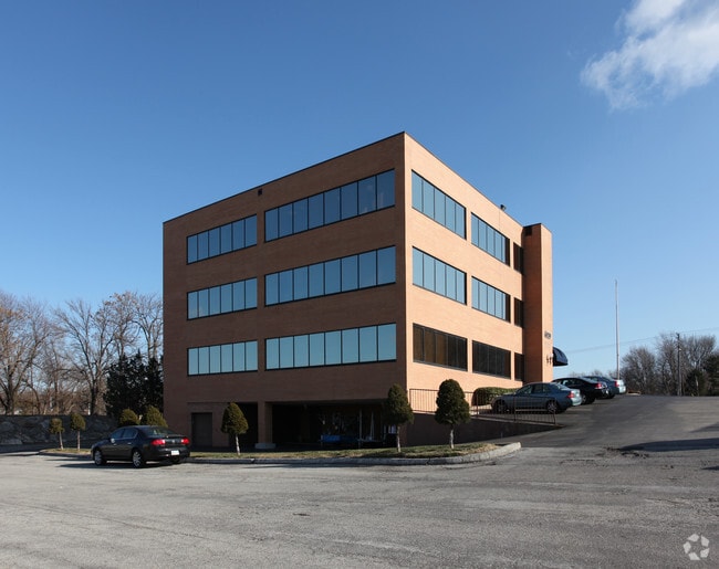
Property Record
6220 Blue Ridge Cut Off, Raytown, MO 64133


Property Detail
6220 Blue Ridge Cut Off
Kansas City, MO-KS
PRIMMS ACRES N 167.70 OF TR DAF: PT OF LOTS 6-7-8-11-12 DA F: BEG ON WLY LI OF BLUE RIDGE CUTOFF 60 S OF N LI OF SD LO T 6 TH WLY 190.98 TH SLY 382.65 TH ELY 100 TH N 42 DEG E
45-310-05-37-01-0-00-000
Jackson
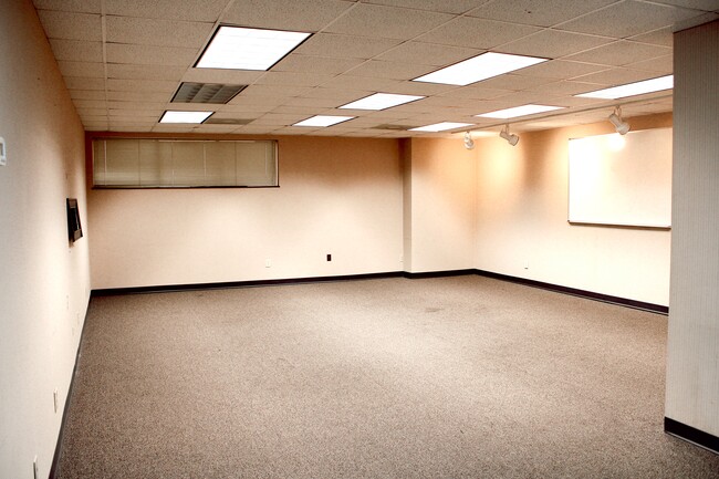
Officebuilding
Missouri
B and X Area of moderate flood hazard, usually the area between the limits of the 100-year and 500-year floods.
6-7
2024
0.71 AC
2025
East Jackson County
012600
Kansas City
14,862 SF
NEARBY LISTINGS FOR SALE OR LEASE
DEMOGRAPHICS near 6220 Blue Ridge Cut Off
1 mile
3 mile
5 mile
2025 Total Population
6,375
49,258
151,225
2030 Population
6,438
49,546
153,537
Pop Growth 2025-2030
+ 0.99%
+ 0.58%
+ 1.53%
Average Age
41
40
40
2025 Total Households
2,752
20,516
62,533
HH Growth 2025-2030
+ 0.98%
+ 0.58%
+ 1.52%
Median Household Inc
$65,378
$66,213
$56,180
Avg Household Size
2.20
2.30
2.30
2025 Avg HH Vehicles
2.00
2.00
2.00
Median Home Value
$156,103
$166,207
$150,999
Median Year Built
1960
1964
1962
Nearby Places
Map Layers
Map Styles
 Street
 Aerial
Transit
 Traffic
 Biking
Places
Listings with unknown addresses are not visible on the map
- Restaurants
- Banks
- Shops
- Fitness
- Groceries
PUBLIC TRANSPORTATION
COMMUTER RAIL
Independence Amtrak Station (Lincoln Service Missouri River Runner - Amtrak, Missouri River Runner - Amtrak)
Drive
Walk
Distance
Independence Amtrak Station (Lincoln Service Missouri River Runner - Amtrak, Missouri River Runner - Amtrak)
15 min
7.4 mi
Kansas City (Lincoln Service Missouri River Runner - Amtrak, Missouri River Runner - Amtrak, Southwest Chief - Amtrak)
Drive
Walk
Distance
Kansas City (Lincoln Service Missouri River Runner - Amtrak, Missouri River Runner - Amtrak, Southwest Chief - Amtrak)
18 min
9.7 mi
AIRPORT
Kansas City International
Drive
Walk
Distance
Kansas City International
41 min
33.0 mi
Freight Ports
Tulsa Port Of Catoosa
Drive
Walk
Distance
Tulsa Port Of Catoosa
265 min
236.1 mi
SALE & LEASE HISTORY
LISTING DATE
SALE/LEASE

Jun 12, 2018
For Sale
Jan 20, 2021
For Lease
Feb 14, 2017
For Lease
Nearby Properties
Address
Land Use
TOTAL SIZE
Lot Size
Zoning
Address
Land Use
TOTAL SIZE
Lot Size
Zoning
963,895 SF
20.27 AC
Address
Land Use
TOTAL SIZE
Lot Size
Zoning
474,624 SF
18.82 AC
Address
Land Use
TOTAL SIZE
Lot Size
Zoning
Address
Land Use
TOTAL SIZE
Lot Size
Zoning
112,500 SF
26.32 AC
Address
Land Use
TOTAL SIZE
Lot Size
Zoning
175,318 SF
26.37 AC
Address
Land Use
TOTAL SIZE
Lot Size
Zoning
137,428 SF
27.76 AC
Address
Land Use
TOTAL SIZE
Lot Size
Zoning
168,184 SF
18.63 AC
Address
Land Use
TOTAL SIZE
Lot Size
Zoning
49,964 SF
39.88 AC
Address
Land Use
TOTAL SIZE
Lot Size
Zoning
389,227 SF
33.30 AC
Address
Land Use
TOTAL SIZE
Lot Size
Zoning
134,082 SF
1.79 AC
Address
Land Use
TOTAL SIZE
Lot Size
Zoning
42,188 SF
7.82 AC
Address
Land Use
TOTAL SIZE
Lot Size
Zoning
34,832 SF
8.29 AC
Address
Land Use
TOTAL SIZE
Lot Size
Zoning
Address
Land Use
TOTAL SIZE
Lot Size
Zoning
82,607 SF
9.90 AC
Address
Land Use
TOTAL SIZE
Lot Size
Zoning
118,908 SF
152 AC
Address
Land Use
TOTAL SIZE
Lot Size
Zoning
Address
Land Use
TOTAL SIZE
Lot Size
Zoning
16,764 SF
154.60 AC
Address
Land Use
TOTAL SIZE
Lot Size
Zoning
286,210 SF
234.92 AC
Address
Land Use
TOTAL SIZE
Lot Size
Zoning
145,569 SF
16.90 AC
Address
Land Use
TOTAL SIZE
Lot Size
Zoning
80,433 SF
7.24 AC
Address
Land Use
TOTAL SIZE
Lot Size
Zoning
176,132 SF
0.27 AC
Address
Land Use
TOTAL SIZE
Lot Size
Zoning
73,434 SF
10.35 AC
Address
Land Use
TOTAL SIZE
Lot Size
Zoning
110,663 SF
19.86 AC
Address
Land Use
TOTAL SIZE
Lot Size
Zoning
71,368 SF
5.64 AC
Address
Land Use
TOTAL SIZE
Lot Size
Zoning
82,432 SF
5.24 AC
Address
Land Use
TOTAL SIZE
Lot Size
Zoning
20,498 SF
9.45 AC
Address
Land Use
TOTAL SIZE
Lot Size
Zoning
43,200 SF
4.37 AC
Address
Land Use
TOTAL SIZE
Lot Size
Zoning
35,646 SF
3.25 AC
Address
Land Use
TOTAL SIZE
Lot Size
Zoning
82,042 SF
11.28 AC
Address
Land Use
TOTAL SIZE
Lot Size
Zoning
67,570 SF
5.71 AC
The World's #1 Commercial Real Estate Marketplace
Connect with us
© 2026 CoStar Group
The information above has been obtained from sources believed reliable. While we do not doubt its accuracy we have not verified it and make no guarantee, warranty or representation about it. It is your responsibility to independently confirm its accuracy and completeness. Any projections, opinions, assumptions, or estimates used are for example only and do not represent the current or future performance of the property. The value of this transaction to you depends on tax and other factors which should be evaluated by your tax, financial, and legal advisors. You and your advisors should conduct a careful, independent investigation of the property to determine to your satisfaction the suitability of the property for your needs.