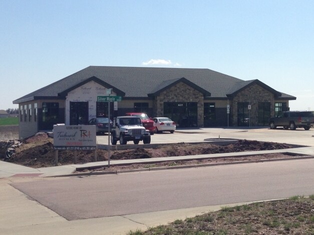
Property Record
6221 E Silver Maple Cir, Sioux Falls, SD 57110

Property Detail
6221 E Silver Maple Cir
Sioux Falls, SD-MN
LOT 3 BLOCK 22 COPPER CREEK ADDITION TO THE CITY OF SIOUX FALLS
86015
MINNEHAHA
Officebuilding
South Dakota
B and X Area of moderate flood hazard, usually the area between the limits of the 100-year and 500-year floods.
3
2024
0.60 AC
2024
Sioux Falls
010401
Other Market Areas
7,508 SF
NEARBY LISTINGS FOR SALE OR LEASE
DEMOGRAPHICS near 6221 E Silver Maple Cir
1 mile
3 mile
5 mile
2024 Total Population
6,946
60,053
118,686
2029 Population
7,497
63,921
126,503
Pop Growth 2024-2029
+ 7.93%
+ 6.44%
+ 6.59%
Average Age
36
38
39
2024 Total Households
2,693
23,249
47,606
HH Growth 2024-2029
+ 8.28%
+ 6.84%
+ 7.10%
Median Household Inc
$78,472
$80,697
$72,781
Avg Household Size
2.50
2.50
2.40
2024 Avg HH Vehicles
2.00
2.00
2.00
Median Home Value
$379,047
$345,733
$320,513
Median Year Built
2010
2000
1992
Nearby Places
Map Layers
Map Styles
 Street
 Aerial
Transit
 Traffic
 Biking
Places
Listings with unknown addresses are not visible on the map
- Restaurants
- Banks
- Shops
- Fitness
- Groceries
PUBLIC TRANSPORTATION
AIRPORT
Joe Foss Field
Drive
Walk
Distance
Joe Foss Field
29 min
9.3 mi
SALE & LEASE HISTORY
LISTING DATE
SALE/LEASE

Sep 20, 2019
For Lease
May 30, 2017
For Lease
Jan 03, 2017
For Lease
Feb 28, 2017
For Lease
Nearby Properties
Address
Land Use
TOTAL SIZE
Lot Size
Zoning
Address
Land Use
TOTAL SIZE
Lot Size
Zoning
11.33 AC
MUNICIPALI
Address
Land Use
TOTAL SIZE
Lot Size
Zoning
15.39 AC
Address
Land Use
TOTAL SIZE
Lot Size
Zoning
4,136 SF
18.95 AC
Address
Land Use
TOTAL SIZE
Lot Size
Zoning
4,358 SF
14.79 AC
Address
Land Use
TOTAL SIZE
Lot Size
Zoning
3,306 SF
17.41 AC
Address
Land Use
TOTAL SIZE
Lot Size
Zoning
94,624 SF
12.31 AC
Address
Land Use
TOTAL SIZE
Lot Size
Zoning
11,800 SF
11.78 AC
Address
Land Use
TOTAL SIZE
Lot Size
Zoning
2,406 SF
13.76 AC
Address
Land Use
TOTAL SIZE
Lot Size
Zoning
8.02 AC
MUNICIPALI
Address
Land Use
TOTAL SIZE
Lot Size
Zoning
17,117 SF
6.51 AC
PD;PLANNED
Address
Land Use
TOTAL SIZE
Lot Size
Zoning
92,195 SF
8 AC
Address
Land Use
TOTAL SIZE
Lot Size
Zoning
87,328 SF
6.92 AC
Address
Land Use
TOTAL SIZE
Lot Size
Zoning
5.85 AC
Address
Land Use
TOTAL SIZE
Lot Size
Zoning
10.24 AC
MUNICIPALI
Address
Land Use
TOTAL SIZE
Lot Size
Zoning
8.09 AC
MUNICIPALI
Address
Land Use
TOTAL SIZE
Lot Size
Zoning
9.15 AC
MUNICIPALI
Address
Land Use
TOTAL SIZE
Lot Size
Zoning
4.64 AC
MUNICIPALI
Address
Land Use
TOTAL SIZE
Lot Size
Zoning
212,260 SF
20.37 AC
Address
Land Use
TOTAL SIZE
Lot Size
Zoning
219,120 SF
18.65 AC
Address
Land Use
TOTAL SIZE
Lot Size
Zoning
83,394 SF
4.46 AC
Address
Land Use
TOTAL SIZE
Lot Size
Zoning
10.39 AC
MUNICIPALI
Address
Land Use
TOTAL SIZE
Lot Size
Zoning
3.77 AC
MUNICIPALI
Address
Land Use
TOTAL SIZE
Lot Size
Zoning
125,520 SF
5.61 AC
Address
Land Use
TOTAL SIZE
Lot Size
Zoning
58,932 SF
4.93 AC
Address
Land Use
TOTAL SIZE
Lot Size
Zoning
134,519 SF
12 AC
Address
Land Use
TOTAL SIZE
Lot Size
Zoning
1,860 SF
86.79 AC
Address
Land Use
TOTAL SIZE
Lot Size
Zoning
1,760 SF
168 AC
RA;APARTME
Address
Land Use
TOTAL SIZE
Lot Size
Zoning
47,617 SF
7.74 AC
Address
Land Use
TOTAL SIZE
Lot Size
Zoning
57,503 SF
6.67 AC
Address
Land Use
TOTAL SIZE
Lot Size
Zoning
8.38 AC
MUNICIPALI
The World's #1 Commercial Real Estate Marketplace
Connect with us
© 2026 CoStar Group
The information above has been obtained from sources believed reliable. While we do not doubt its accuracy we have not verified it and make no guarantee, warranty or representation about it. It is your responsibility to independently confirm its accuracy and completeness. Any projections, opinions, assumptions, or estimates used are for example only and do not represent the current or future performance of the property. The value of this transaction to you depends on tax and other factors which should be evaluated by your tax, financial, and legal advisors. You and your advisors should conduct a careful, independent investigation of the property to determine to your satisfaction the suitability of the property for your needs.