Property Record
1101 N 62Nd St N, Milwaukee, WI 53213
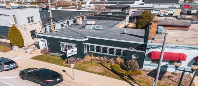

This Property Is For Sale
Current Lease Availabilities
NEARBY LISTINGS FOR SALE OR LEASE
Property Detail
1101 N 62Nd St N
Milwaukee-Waukesha-West Allis, WI
Assessors Plat No 11
384-0004-000
NORTH 138.21 FT OF LOT 1
Commercialnec
Milwaukee
X
Wisconsin
55079C0086E
1
2024
0.39 AC
2024
Milwaukee West
091200
Milwaukee/Madison
DEMOGRAPHICS near 1101 N 62Nd St N
1 Mile
3 Mile
5 Mile
2024 Total Population
18,377
186,122
503,211
2029 Population
17,897
182,825
495,191
Pop Growth 2024-2029
(2.61%)
(1.77%)
(1.59%)
Average Age
39
36
37
2024 Total Households
8,696
77,669
209,399
HH Growth 2024-2029
(2.68%)
(1.82%)
(1.62%)
Median Household Inc
$85,392
$50,541
$49,306
Avg Household Size
2.10
2.30
2.30
2024 Avg HH Vehicles
2.00
1.00
1.00
Median Home Value
$276,500
$183,726
$172,097
Median Year Built
1946
1948
1950
Nearby Places
Map Layers
Map Styles
 Street
 Aerial
- Restaurants
- Banks
- Shops
- Fitness
- Groceries
PUBLIC TRANSPORTATION
COMMUTER RAIL
Milwaukee (Empire Builder - Amtrak)
DRIVE
WALK
Distance
Milwaukee (Empire Builder - Amtrak)
9 min
4.8 mi
AIRPORT
General Mitchell International
DRIVE
WALK
Distance
General Mitchell International
21 min
11.4 mi
Freight Ports
Port Milwaukee
DRIVE
WALK
Distance
Port Milwaukee
14 min
7.2 mi
Nearby Properties
Address
Land Use
TOTAL SIZE
Lot Size
Zoning
Address
Land Use
TOTAL SIZE
Lot Size
Zoning
3.04 AC
TL
Address
Land Use
TOTAL SIZE
Lot Size
Zoning
36.11 AC
Address
Land Use
TOTAL SIZE
Lot Size
Zoning
Address
Land Use
TOTAL SIZE
Lot Size
Zoning
122.53 AC
TL
Address
Land Use
TOTAL SIZE
Lot Size
Zoning
23.16 AC
Address
Land Use
TOTAL SIZE
Lot Size
Zoning
262,109 SF
2.24 AC
PD
Address
Land Use
TOTAL SIZE
Lot Size
Zoning
0.07 AC
RS6
Address
Land Use
TOTAL SIZE
Lot Size
Zoning
1,709,128 SF
9.32 AC
PD
Address
Land Use
TOTAL SIZE
Lot Size
Zoning
13.48 AC
Address
Land Use
TOTAL SIZE
Lot Size
Zoning
5.12 AC
Address
Land Use
TOTAL SIZE
Lot Size
Zoning
Address
Land Use
TOTAL SIZE
Lot Size
Zoning
10.22 AC
SP-RP
Address
Land Use
TOTAL SIZE
Lot Size
Zoning
68.35 AC
TL
Address
Land Use
TOTAL SIZE
Lot Size
Zoning
Address
Land Use
TOTAL SIZE
Lot Size
Zoning
8,881 SF
7.52 AC
Address
Land Use
TOTAL SIZE
Lot Size
Zoning
9.33 AC
PUD
Address
Land Use
TOTAL SIZE
Lot Size
Zoning
47.96 AC
TL
Address
Land Use
TOTAL SIZE
Lot Size
Zoning
3.74 AC
PUD
Address
Land Use
TOTAL SIZE
Lot Size
Zoning
106,495 SF
9.70 AC
PUD
Address
Land Use
TOTAL SIZE
Lot Size
Zoning
1.76 AC
LB2
Address
Land Use
TOTAL SIZE
Lot Size
Zoning
10.92 AC
Address
Land Use
TOTAL SIZE
Lot Size
Zoning
2.13 AC
SP-MED
Address
Land Use
TOTAL SIZE
Lot Size
Zoning
Address
Land Use
TOTAL SIZE
Lot Size
Zoning
39.81 AC
Address
Land Use
TOTAL SIZE
Lot Size
Zoning
29,664 SF
1.83 AC
C2
Address
Land Use
TOTAL SIZE
Lot Size
Zoning
8.78 AC
Address
Land Use
TOTAL SIZE
Lot Size
Zoning
0.36 AC
Address
Land Use
TOTAL SIZE
Lot Size
Zoning
Address
Land Use
TOTAL SIZE
Lot Size
Zoning
7.55 AC
SP-RP
Address
Land Use
TOTAL SIZE
Lot Size
Zoning
The World's #1 Commercial Real Estate Marketplace
Connect with us
© 2025 CoStar Group
The information above has been obtained from sources believed reliable. While we do not doubt its accuracy we have not verified it and make no guarantee, warranty or representation about it. It is your responsibility to independently confirm its accuracy and completeness. Any projections, opinions, assumptions, or estimates used are for example only and do not represent the current or future performance of the property. The value of this transaction to you depends on tax and other factors which should be evaluated by your tax, financial, and legal advisors. You and your advisors should conduct a careful, independent investigation of the property to determine to your satisfaction the suitability of the property for your needs.