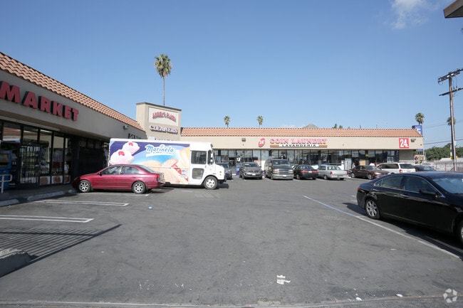
Property Record
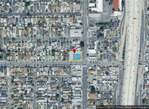
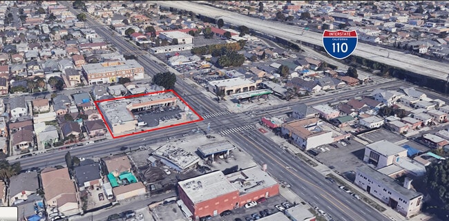
6225 S Figueroa St, Los Angeles, CA 90003

NEARBY LISTINGS FOR SALE OR LEASE
Property Detail
6225 S Figueroa St
Los Angeles-Long Beach-Glendale, CA
Winton & Mcleods Figueroa Street
6004-022-034
M B 8-173 LOTS 58 AND 59 AND LOT 60 BLK C
Regionalshoppingcenterormallwithanchorstore
Los Angeles
X
California
06037C1781G
58,59
2024
0.41 AC
2025
Inglewood/South LA
237102
Los Angeles
8,918 SF
DEMOGRAPHICS near 6225 S Figueroa St
1 Mile
3 Mile
5 Mile
2024 Total Population
61,341
459,801
1,101,260
2029 Population
58,774
439,782
1,059,769
Pop Growth 2024-2029
(4.18%)
(4.35%)
(3.77%)
Average Age
35
35
37
2024 Total Households
15,470
122,122
335,701
HH Growth 2024-2029
(4.51%)
(4.59%)
(3.70%)
Median Household Inc
$47,560
$48,970
$51,468
Avg Household Size
3.70
3.50
3.10
2024 Avg HH Vehicles
2.00
2.00
2.00
Median Home Value
$620,396
$609,251
$664,271
Median Year Built
1949
1949
1953
Nearby Places
- Restaurants
- Banks
- Shops
- Fitness
- Groceries
PUBLIC TRANSPORTATION
COMMUTER RAIL
Los Angeles (Coast Starlight - Amtrak, Pacific Surfliner - Amtrak, Southwest Chief - Amtrak, Texas Eagle - Amtrak)
DRIVE
WALK
Distance
Los Angeles (Coast Starlight - Amtrak, Pacific Surfliner - Amtrak, Southwest Chief - Amtrak, Texas Eagle - Amtrak)
11 min
7.3 mi
Union Station (91 Line - Southern California Regional Rail Authority (Metrolink), Antelope Valley Line - Southern California Regional Rail Authority (Metrolink), Orange County Line - Southern California Regional Rail Authority (Metrolink), Riverside Line - Southern California Regional Rail Authority (Metrolink), San Bernardino Line - Southern California Regional Rail Authority (Metrolink), Ventura County Line - Southern California Regional Rail Authority (Metrolink))
DRIVE
WALK
Distance
Union Station (91 Line - Southern California Regional Rail Authority (Metrolink), Antelope Valley Line - Southern California Regional Rail Authority (Metrolink), Orange County Line - Southern California Regional Rail Authority (Metrolink), Riverside Line - Southern California Regional Rail Authority (Metrolink), San Bernardino Line - Southern California Regional Rail Authority (Metrolink), Ventura County Line - Southern California Regional Rail Authority (Metrolink))
13 min
7.5 mi
AIRPORT
Los Angeles International
DRIVE
WALK
Distance
Los Angeles International
17 min
9.0 mi
Long Beach (Daugherty Field)
DRIVE
WALK
Distance
Long Beach (Daugherty Field)
23 min
17.5 mi
Bob Hope
DRIVE
WALK
Distance
Bob Hope
30 min
22.4 mi
Freight Ports
Port of Long Beach
DRIVE
WALK
Distance
Port of Long Beach
26 min
19.4 mi
SALE & LEASE HISTORY
LISTING DATE
SALE/LEASE

Jan 29, 2020
For Lease
Dec 01, 2016
For Lease
Apr 22, 2021
For Lease
Nearby Properties
Address
Land Use
TOTAL SIZE
Lot Size
Zoning
Address
Land Use
TOTAL SIZE
Lot Size
Zoning
969,516 SF
14.75 AC
Address
Land Use
TOTAL SIZE
Lot Size
Zoning
420,864 SF
63.07 AC
LAUSC-1A
Address
Land Use
TOTAL SIZE
Lot Size
Zoning
256,059 SF
Address
Land Use
TOTAL SIZE
Lot Size
Zoning
200,689 SF
5.79 AC
LAUSC-1A
Address
Land Use
TOTAL SIZE
Lot Size
Zoning
337,025 SF
14.59 AC
LAUSC-1A
Address
Land Use
TOTAL SIZE
Lot Size
Zoning
666,499 SF
10.63 AC
LAC2
Address
Land Use
TOTAL SIZE
Lot Size
Zoning
298,630 SF
4.64 AC
LAUSC-1B
Address
Land Use
TOTAL SIZE
Lot Size
Zoning
377,946 SF
5.03 AC
LAUSC-1A
Address
Land Use
TOTAL SIZE
Lot Size
Zoning
112,636 SF
24.20 AC
LAUSC-1A
Address
Land Use
TOTAL SIZE
Lot Size
Zoning
108,598 SF
15.93 AC
LCC3*
Address
Land Use
TOTAL SIZE
Lot Size
Zoning
188,146 SF
1.54 AC
LAUSC-1A
Address
Land Use
TOTAL SIZE
Lot Size
Zoning
Address
Land Use
TOTAL SIZE
Lot Size
Zoning
1 AC
LAC2
Address
Land Use
TOTAL SIZE
Lot Size
Zoning
1 AC
LAC2
Address
Land Use
TOTAL SIZE
Lot Size
Zoning
279,682 SF
6.98 AC
VEM*
Address
Land Use
TOTAL SIZE
Lot Size
Zoning
95,639 SF
0.53 AC
LAC2
Address
Land Use
TOTAL SIZE
Lot Size
Zoning
116,827 SF
0.64 AC
LAC2
Address
Land Use
TOTAL SIZE
Lot Size
Zoning
57,488 SF
4.30 AC
LAPF
Address
Land Use
TOTAL SIZE
Lot Size
Zoning
564,529 SF
2.67 AC
LAUSC-1B
Address
Land Use
TOTAL SIZE
Lot Size
Zoning
261,540 SF
10.85 AC
VEM*
Address
Land Use
TOTAL SIZE
Lot Size
Zoning
386,865 SF
6 AC
VEM*
Address
Land Use
TOTAL SIZE
Lot Size
Zoning
150,790 SF
0.74 AC
LAC2
Address
Land Use
TOTAL SIZE
Lot Size
Zoning
261,502 SF
0.84 AC
LACM
Address
Land Use
TOTAL SIZE
Lot Size
Zoning
134,044 SF
1.90 AC
LAC2
Address
Land Use
TOTAL SIZE
Lot Size
Zoning
132,544 SF
3.24 AC
LAM2
Address
Land Use
TOTAL SIZE
Lot Size
Zoning
729,505 SF
8.74 AC
LAUSC-1A
Address
Land Use
TOTAL SIZE
Lot Size
Zoning
115,340 SF
3.21 AC
LAM2
Address
Land Use
TOTAL SIZE
Lot Size
Zoning
165,235 SF
1.13 AC
LAM2
Address
Land Use
TOTAL SIZE
Lot Size
Zoning
353,009 SF
3.97 AC
LAUSC-2
Address
Land Use
TOTAL SIZE
Lot Size
Zoning
81,735 SF
4.10 AC
LAR4
The World's #1 Commercial Real Estate Marketplace
Connect with us
© 2025 CoStar Group
The information above has been obtained from sources believed reliable. While we do not doubt its accuracy we have not verified it and make no guarantee, warranty or representation about it. It is your responsibility to independently confirm its accuracy and completeness. Any projections, opinions, assumptions, or estimates used are for example only and do not represent the current or future performance of the property. The value of this transaction to you depends on tax and other factors which should be evaluated by your tax, financial, and legal advisors. You and your advisors should conduct a careful, independent investigation of the property to determine to your satisfaction the suitability of the property for your needs.