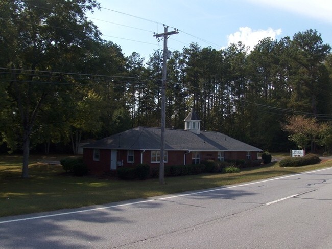
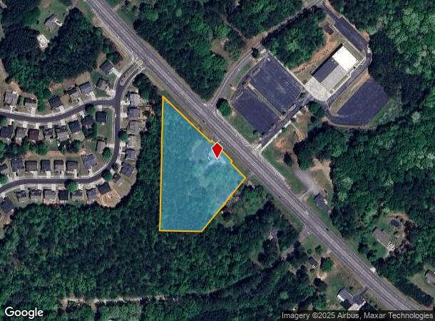
Property Record
6225 Highway 92, Fairburn, GA 30213
NEARBY LISTINGS FOR SALE OR LEASE
Property Detail
6225 Highway 92
Religious
Fulton
X
Georgia
13121C0454F
3.36 AC
0
North Clayton/Airport
2025
Atlanta
010535
Atlanta-Sandy Springs-Roswell, GA
2,621 SF
09F-2001-0090-022-5
DEMOGRAPHICS near 6225 Highway 92
1 Mile
3 Mile
5 Mile
2024 Total Population
4,683
38,284
86,291
2029 Population
4,813
39,597
89,242
Pop Growth 2024-2029
+ 2.78%
+ 3.43%
+ 3.42%
Average Age
38
37
37
2024 Total Households
1,560
13,598
31,503
HH Growth 2024-2029
+ 2.95%
+ 3.46%
+ 3.49%
Median Household Inc
$72,413
$67,693
$69,482
Avg Household Size
2.90
2.80
2.70
2024 Avg HH Vehicles
2.00
2.00
2.00
Median Home Value
$233,177
$227,836
$231,226
Median Year Built
2001
2003
2002
Nearby Places
Map Layers
Map Styles
 Street
 Aerial
- Restaurants
- Banks
- Shops
- Fitness
- Groceries
PUBLIC TRANSPORTATION
AIRPORT
Hartsfield - Jackson Atlanta International
DRIVE
WALK
Distance
Hartsfield - Jackson Atlanta International
24 min
14.9 mi
Freight Ports
Georgia Ports - Savannah
DRIVE
WALK
Distance
Georgia Ports - Savannah
286 min
250.1 mi
Nearby Properties
Address
Land Use
TOTAL SIZE
Lot Size
Zoning
Address
Land Use
TOTAL SIZE
Lot Size
Zoning
938,714 SF
103.25 AC
AG1
Address
Land Use
TOTAL SIZE
Lot Size
Zoning
14.13 AC
TCMU
Address
Land Use
TOTAL SIZE
Lot Size
Zoning
74.44 AC
Address
Land Use
TOTAL SIZE
Lot Size
Zoning
595,060 SF
62.71 AC
Address
Land Use
TOTAL SIZE
Lot Size
Zoning
1,325,500 SF
101.81 AC
AG1
Address
Land Use
TOTAL SIZE
Lot Size
Zoning
1,226,360 SF
18.72 AC
AG1
Address
Land Use
TOTAL SIZE
Lot Size
Zoning
78.33 AC
Address
Land Use
TOTAL SIZE
Lot Size
Zoning
1,776,355 SF
13.40 AC
PD
Address
Land Use
TOTAL SIZE
Lot Size
Zoning
1,040,000 SF
74.64 AC
AG1
Address
Land Use
TOTAL SIZE
Lot Size
Zoning
1,873,575 SF
50.47 AC
RM
Address
Land Use
TOTAL SIZE
Lot Size
Zoning
14.83 AC
AG1
Address
Land Use
TOTAL SIZE
Lot Size
Zoning
156,882 SF
25 AC
AG1
Address
Land Use
TOTAL SIZE
Lot Size
Zoning
130,516 SF
6.50 AC
C1
Address
Land Use
TOTAL SIZE
Lot Size
Zoning
572,000 SF
46.35 AC
AG1
Address
Land Use
TOTAL SIZE
Lot Size
Zoning
567,000 SF
41.83 AC
AG1
Address
Land Use
TOTAL SIZE
Lot Size
Zoning
499,950 SF
63.40 AC
AG1
Address
Land Use
TOTAL SIZE
Lot Size
Zoning
1,320,344 SF
0.35 AC
MIX
Address
Land Use
TOTAL SIZE
Lot Size
Zoning
661,312 SF
11.40 AC
RM
Address
Land Use
TOTAL SIZE
Lot Size
Zoning
23 AC
AG1
Address
Land Use
TOTAL SIZE
Lot Size
Zoning
32.52 AC
C2
Address
Land Use
TOTAL SIZE
Lot Size
Zoning
24.53 AC
Address
Land Use
TOTAL SIZE
Lot Size
Zoning
1,566 SF
41.68 AC
AG1
Address
Land Use
TOTAL SIZE
Lot Size
Zoning
388,000 SF
40.74 AC
M1
Address
Land Use
TOTAL SIZE
Lot Size
Zoning
1,221 SF
10 AC
RM
Address
Land Use
TOTAL SIZE
Lot Size
Zoning
327,822 SF
0.16 AC
MIX
Address
Land Use
TOTAL SIZE
Lot Size
Zoning
169,212 SF
0.20 AC
MIX
Address
Land Use
TOTAL SIZE
Lot Size
Zoning
3,024 SF
14 AC
RM
Address
Land Use
TOTAL SIZE
Lot Size
Zoning
12,406 SF
4.88 AC
M1
Address
Land Use
TOTAL SIZE
Lot Size
Zoning
31.25 AC
Address
Land Use
TOTAL SIZE
Lot Size
Zoning
83,102 SF
10.75 AC
MIX
The World's #1 Commercial Real Estate Marketplace
Connect with us
© 2025 CoStar Group
The information above has been obtained from sources believed reliable. While we do not doubt its accuracy we have not verified it and make no guarantee, warranty or representation about it. It is your responsibility to independently confirm its accuracy and completeness. Any projections, opinions, assumptions, or estimates used are for example only and do not represent the current or future performance of the property. The value of this transaction to you depends on tax and other factors which should be evaluated by your tax, financial, and legal advisors. You and your advisors should conduct a careful, independent investigation of the property to determine to your satisfaction the suitability of the property for your needs.