Property Record
6225 Lark Rd Nw, Sauk Rapids, MN 56379
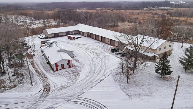

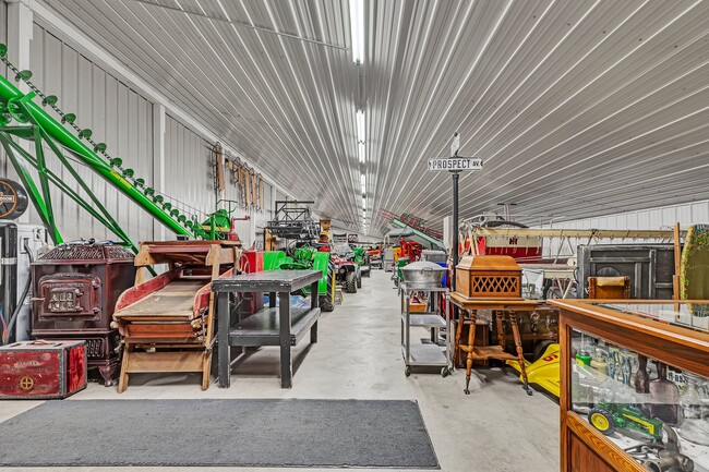
This Property Is For Sale
Current Lease Availabilities
NEARBY LISTINGS FOR SALE OR LEASE
Property Detail
6225 Lark Rd Nw
12.00471.01
SECT-34 TWP-037 RANGE-031 3.00 AC PART OF S1/2 NE1/4 COMM 600 FT W OF C/L OF OLD MN HWY 10 TH S'LY 325 FT PARALLEL W/N LINE
Utilities
Benton
X
Minnesota
27145C0420E
3 AC
2025
Benton County
2025
Minneapolis/St Paul
020205
St. Cloud, MN
6,624 SF
DEMOGRAPHICS near 6225 Lark Rd Nw
1 Mile
3 Mile
5 Mile
2024 Total Population
317
9,540
35,544
2029 Population
319
9,681
36,179
Pop Growth 2024-2029
+ 0.63%
+ 1.48%
+ 1.79%
Average Age
39
39
38
2024 Total Households
112
3,642
13,715
HH Growth 2024-2029
0.00%
+ 1.37%
+ 1.76%
Median Household Inc
$99,374
$77,968
$71,626
Avg Household Size
2.80
2.60
2.50
2024 Avg HH Vehicles
3.00
2.00
2.00
Median Home Value
$370,833
$264,022
$247,459
Median Year Built
1993
1987
1993
Nearby Places
Map Layers
Map Styles
 Street
 Aerial
- Restaurants
- Banks
- Shops
- Fitness
- Groceries
PUBLIC TRANSPORTATION
COMMUTER RAIL
St. Cloud Amtrak Station (Empire Builder - Amtrak)
DRIVE
WALK
Distance
St. Cloud Amtrak Station (Empire Builder - Amtrak)
10 min
7.3 mi
Freight Ports
Port Milwaukee
DRIVE
WALK
Distance
Port Milwaukee
457 min
408.7 mi
Nearby Properties
Address
Land Use
TOTAL SIZE
Lot Size
Zoning
Address
Land Use
TOTAL SIZE
Lot Size
Zoning
250,584 SF
77.75 AC
Address
Land Use
TOTAL SIZE
Lot Size
Zoning
183,964 SF
39.05 AC
Address
Land Use
TOTAL SIZE
Lot Size
Zoning
10,800 SF
24.94 AC
Address
Land Use
TOTAL SIZE
Lot Size
Zoning
5.76 AC
Address
Land Use
TOTAL SIZE
Lot Size
Zoning
4.14 AC
Address
Land Use
TOTAL SIZE
Lot Size
Zoning
9.03 AC
Address
Land Use
TOTAL SIZE
Lot Size
Zoning
27,268 SF
8.39 AC
Address
Land Use
TOTAL SIZE
Lot Size
Zoning
68,146 SF
3.16 AC
Address
Land Use
TOTAL SIZE
Lot Size
Zoning
55,000 SF
3.51 AC
Address
Land Use
TOTAL SIZE
Lot Size
Zoning
2.50 AC
Address
Land Use
TOTAL SIZE
Lot Size
Zoning
377,672 SF
5.65 AC
Address
Land Use
TOTAL SIZE
Lot Size
Zoning
9,900 SF
3 AC
Address
Land Use
TOTAL SIZE
Lot Size
Zoning
25,050 SF
7.50 AC
Address
Land Use
TOTAL SIZE
Lot Size
Zoning
23,014 SF
2.02 AC
Address
Land Use
TOTAL SIZE
Lot Size
Zoning
2.47 AC
Address
Land Use
TOTAL SIZE
Lot Size
Zoning
28,824 SF
22.44 AC
Address
Land Use
TOTAL SIZE
Lot Size
Zoning
1.77 AC
Address
Land Use
TOTAL SIZE
Lot Size
Zoning
38,867 SF
4.71 AC
Address
Land Use
TOTAL SIZE
Lot Size
Zoning
2.02 AC
Address
Land Use
TOTAL SIZE
Lot Size
Zoning
2.04 AC
Address
Land Use
TOTAL SIZE
Lot Size
Zoning
9,490 SF
184.16 AC
Address
Land Use
TOTAL SIZE
Lot Size
Zoning
9,600 SF
4.86 AC
Address
Land Use
TOTAL SIZE
Lot Size
Zoning
5,402 SF
10.22 AC
Address
Land Use
TOTAL SIZE
Lot Size
Zoning
11,760 SF
7.39 AC
Address
Land Use
TOTAL SIZE
Lot Size
Zoning
1.82 AC
Address
Land Use
TOTAL SIZE
Lot Size
Zoning
0.94 AC
Address
Land Use
TOTAL SIZE
Lot Size
Zoning
1.90 AC
Address
Land Use
TOTAL SIZE
Lot Size
Zoning
1.60 AC
Address
Land Use
TOTAL SIZE
Lot Size
Zoning
73.78 AC
The World's #1 Commercial Real Estate Marketplace
Connect with us
© 2026 CoStar Group
The information above has been obtained from sources believed reliable. While we do not doubt its accuracy we have not verified it and make no guarantee, warranty or representation about it. It is your responsibility to independently confirm its accuracy and completeness. Any projections, opinions, assumptions, or estimates used are for example only and do not represent the current or future performance of the property. The value of this transaction to you depends on tax and other factors which should be evaluated by your tax, financial, and legal advisors. You and your advisors should conduct a careful, independent investigation of the property to determine to your satisfaction the suitability of the property for your needs.