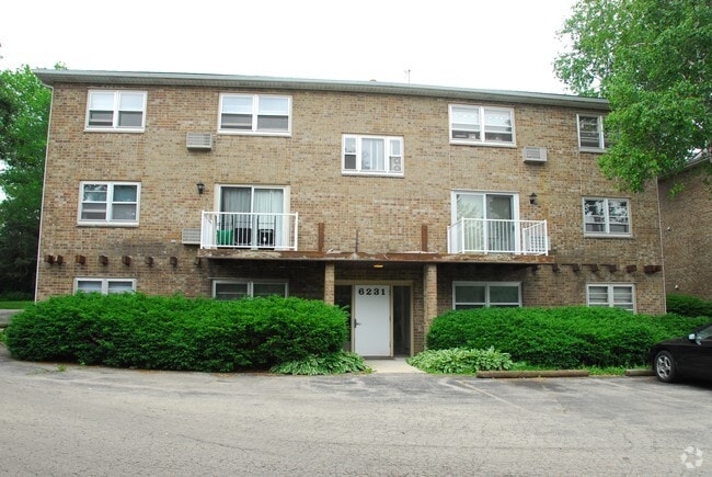
Property Record
6231 University Ave, Middleton, WI 53562
NEARBY LISTINGS FOR SALE OR LEASE
Property Detail
6231 University Ave
Madison, WI
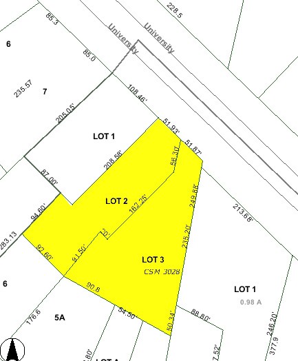
Certified Survey Map No 3028 As Recorded
0708-131-0314-3
CERTIFIED SURVEY MAP NO 3028 AS RECORDED IN DANE COUNTY REGISTER OF DEEDS IN VOL 12 PAGE 10 OF CERTIFIED SURVEYS, LOT 3.
Commercialnec
Dane
X
Wisconsin
55025C0403G
3
2024
0.74 AC
2024
Meadows
011101
Milwaukee/Madison
3,416 SF
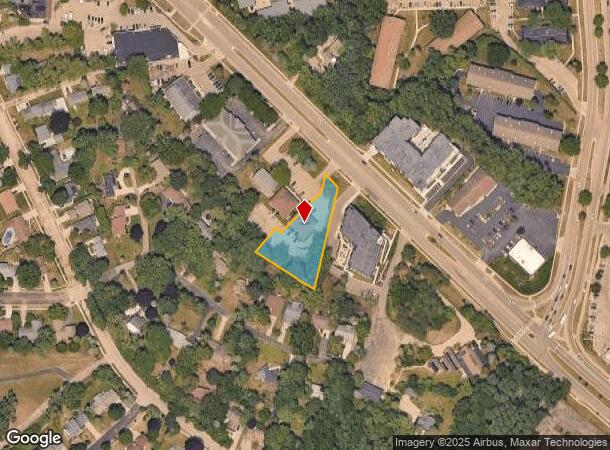
DEMOGRAPHICS near 6231 University Ave
1 Mile
3 Mile
5 Mile
2024 Total Population
9,513
68,598
166,179
2029 Population
9,853
71,414
171,775
Pop Growth 2024-2029
+ 3.57%
+ 4.11%
+ 3.37%
Average Age
42
41
37
2024 Total Households
4,392
32,339
70,333
HH Growth 2024-2029
+ 3.69%
+ 4.20%
+ 3.65%
Median Household Inc
$84,912
$80,622
$74,319
Avg Household Size
2.10
2.10
2.20
2024 Avg HH Vehicles
2.00
2.00
2.00
Median Home Value
$425,303
$415,274
$398,727
Median Year Built
1976
1981
1982
Nearby Places
Map Layers
Map Styles
 Street
 Aerial
- Restaurants
- Banks
- Shops
- Fitness
- Groceries
PUBLIC TRANSPORTATION
AIRPORT
Dane County Regional/Truax Field
DRIVE
WALK
Distance
Dane County Regional/Truax Field
22 min
11.8 mi
Nearby Properties
Address
Land Use
TOTAL SIZE
Lot Size
Zoning
Address
Land Use
TOTAL SIZE
Lot Size
Zoning
82,796 SF
9.26 AC
SE
Address
Land Use
TOTAL SIZE
Lot Size
Zoning
69,336 SF
26.90 AC
SE
Address
Land Use
TOTAL SIZE
Lot Size
Zoning
226,593 SF
28.49 AC
PD
Address
Land Use
TOTAL SIZE
Lot Size
Zoning
291,526 SF
2.89 AC
PD
Address
Land Use
TOTAL SIZE
Lot Size
Zoning
354,461 SF
37.40 AC
RMX
Address
Land Use
TOTAL SIZE
Lot Size
Zoning
15.61 AC
Address
Land Use
TOTAL SIZE
Lot Size
Zoning
700,496 SF
23.94 AC
SR-V2
Address
Land Use
TOTAL SIZE
Lot Size
Zoning
56,000 SF
23.87 AC
SE
Address
Land Use
TOTAL SIZE
Lot Size
Zoning
37,909 SF
10.27 AC
SEC
Address
Land Use
TOTAL SIZE
Lot Size
Zoning
203,672 SF
7.34 AC
PD
Address
Land Use
TOTAL SIZE
Lot Size
Zoning
349,680 SF
6.28 AC
TR-U2
Address
Land Use
TOTAL SIZE
Lot Size
Zoning
420,780 SF
10.14 AC
PD
Address
Land Use
TOTAL SIZE
Lot Size
Zoning
8.48 AC
Address
Land Use
TOTAL SIZE
Lot Size
Zoning
1.44 AC
TE
Address
Land Use
TOTAL SIZE
Lot Size
Zoning
169,563 SF
19.82 AC
SEC
Address
Land Use
TOTAL SIZE
Lot Size
Zoning
51,205 SF
9.32 AC
SE
Address
Land Use
TOTAL SIZE
Lot Size
Zoning
467,400 SF
6.17 AC
TR-U2
Address
Land Use
TOTAL SIZE
Lot Size
Zoning
10.12 AC
Address
Land Use
TOTAL SIZE
Lot Size
Zoning
5.95 AC
Address
Land Use
TOTAL SIZE
Lot Size
Zoning
11.09 AC
Address
Land Use
TOTAL SIZE
Lot Size
Zoning
2.91 AC
SE
Address
Land Use
TOTAL SIZE
Lot Size
Zoning
326,724 SF
4.23 AC
PD
Address
Land Use
TOTAL SIZE
Lot Size
Zoning
254,922 SF
11.97 AC
PD
Address
Land Use
TOTAL SIZE
Lot Size
Zoning
159,686 SF
7.39 AC
SEC
Address
Land Use
TOTAL SIZE
Lot Size
Zoning
Address
Land Use
TOTAL SIZE
Lot Size
Zoning
4.37 AC
Address
Land Use
TOTAL SIZE
Lot Size
Zoning
Address
Land Use
TOTAL SIZE
Lot Size
Zoning
37,909 SF
10.27 AC
SEC
Address
Land Use
TOTAL SIZE
Lot Size
Zoning
237,225 SF
1.84 AC
PD
Address
Land Use
TOTAL SIZE
Lot Size
Zoning
2.98 AC
TR-U2
The World's #1 Commercial Real Estate Marketplace
Connect with us
© 2025 CoStar Group
The information above has been obtained from sources believed reliable. While we do not doubt its accuracy we have not verified it and make no guarantee, warranty or representation about it. It is your responsibility to independently confirm its accuracy and completeness. Any projections, opinions, assumptions, or estimates used are for example only and do not represent the current or future performance of the property. The value of this transaction to you depends on tax and other factors which should be evaluated by your tax, financial, and legal advisors. You and your advisors should conduct a careful, independent investigation of the property to determine to your satisfaction the suitability of the property for your needs.