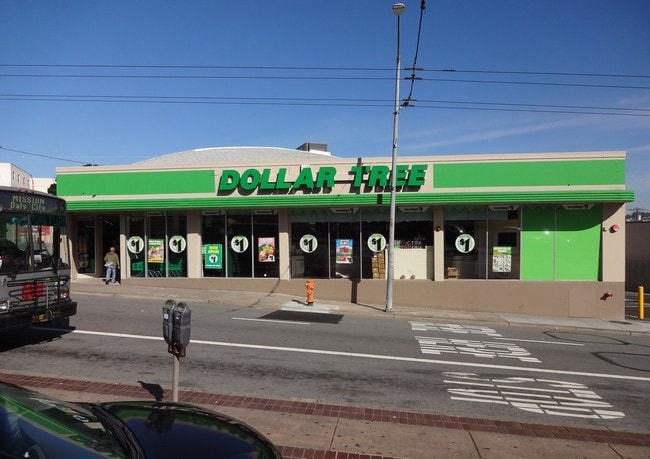
Property Record
6232 Mission St, Daly City, CA 94014


Current Lease Availabilities
NEARBY LISTINGS FOR SALE OR LEASE
Property Detail
6232 Mission St
San Francisco-Redwood City-South San Francisco, CA
Abbey Tract
004-041-100
LOTS 11 12 13 14 & PTN LOTS 6 7 8 12 & 15 ASSESSORS MAP OF ABBEY TRACT CITY OF DALY CITY
Storebuilding
San Mateo
X
California
06081C0029F
11,6
2024
0.28 AC
2025
Brisbane/Daly City
600701
San Francisco
8,000 SF
DEMOGRAPHICS near 6232 Mission St
1 Mile
3 Mile
5 Mile
2024 Total Population
51,767
251,361
645,003
2029 Population
47,545
231,915
597,628
Pop Growth 2024-2029
(8.16%)
(7.74%)
(7.34%)
Average Age
42
43
42
2024 Total Households
15,005
80,520
230,417
HH Growth 2024-2029
(8.43%)
(8.05%)
(7.72%)
Median Household Inc
$102,106
$113,596
$125,976
Avg Household Size
3.20
3.00
2.70
2024 Avg HH Vehicles
2.00
2.00
2.00
Median Home Value
$982,377
$1,068,889
$1,083,245
Median Year Built
1954
1954
1951
Nearby Places
Map Layers
Map Styles
 Street
 Aerial
- Restaurants
- Banks
- Shops
- Fitness
- Groceries
PUBLIC TRANSPORTATION
TRANSIT/SUBWAY
Daly City Station (Dublin/Pleasanton - Millbrae - Bay Area Rapid Transit (BART), Fremont - Daly City - Bay Area Rapid Transit (BART), Pittsburg/Bay Point - San Francisco International - Bay Area Rapid Transit (BART), Richmond - Millbrae - Bay Area Rapid Transit (BART))
DRIVE
WALK
Distance
Daly City Station (Dublin/Pleasanton - Millbrae - Bay Area Rapid Transit (BART), Fremont - Daly City - Bay Area Rapid Transit (BART), Pittsburg/Bay Point - San Francisco International - Bay Area Rapid Transit (BART), Richmond - Millbrae - Bay Area Rapid Transit (BART))
2 min
11 min
0.6 mi
Broad And Orizaba (M Ocean View - San Francisco Municipal Railway (MUNI Metro), OCEAN VIEW - San Francisco Municipal Railway (MUNI Metro))
DRIVE
WALK
Distance
Broad And Orizaba (M Ocean View - San Francisco Municipal Railway (MUNI Metro), OCEAN VIEW - San Francisco Municipal Railway (MUNI Metro))
3 min
13 min
0.7 mi
Orizaba Ave & Broad St (OCEAN VIEW - San Francisco Municipal Transportation Agency)
DRIVE
WALK
Distance
Orizaba Ave & Broad St (OCEAN VIEW - San Francisco Municipal Transportation Agency)
3 min
13 min
0.7 mi
Broad St & Capitol Ave (OCEAN VIEW - San Francisco Municipal Transportation Agency)
DRIVE
WALK
Distance
Broad St & Capitol Ave (OCEAN VIEW - San Francisco Municipal Transportation Agency)
2 min
14 min
0.8 mi
Broad And Capitol (M Ocean View - San Francisco Municipal Railway (MUNI Metro))
DRIVE
WALK
Distance
Broad And Capitol (M Ocean View - San Francisco Municipal Railway (MUNI Metro))
2 min
14 min
0.8 mi
COMMUTER RAIL
Bayshore Caltrain Station (Local - Caltrain (Caltrain), Local Weekday - Caltrain (Caltrain), Local Weekend - Caltrain (Caltrain))
DRIVE
WALK
Distance
Bayshore Caltrain Station (Local - Caltrain (Caltrain), Local Weekday - Caltrain (Caltrain), Local Weekend - Caltrain (Caltrain))
9 min
5.9 mi
South San Francisco (Caltrain - Caltrain (Caltrain), Express - Caltrain (Caltrain), Limited - Caltrain (Caltrain), Local Weekday - Caltrain (Caltrain), Local Weekend - Caltrain (Caltrain))
DRIVE
WALK
Distance
South San Francisco (Caltrain - Caltrain (Caltrain), Express - Caltrain (Caltrain), Limited - Caltrain (Caltrain), Local Weekday - Caltrain (Caltrain), Local Weekend - Caltrain (Caltrain))
13 min
6.8 mi
AIRPORT
San Francisco International
DRIVE
WALK
Distance
San Francisco International
18 min
11.0 mi
Metro Oakland International
DRIVE
WALK
Distance
Metro Oakland International
38 min
26.4 mi
Freight Ports
Port of San Francisco
DRIVE
WALK
Distance
Port of San Francisco
14 min
9.1 mi
Nearby Properties
Address
Land Use
TOTAL SIZE
Lot Size
Zoning
Address
Land Use
TOTAL SIZE
Lot Size
Zoning
411,904 SF
21.74 AC
C2
Address
Land Use
TOTAL SIZE
Lot Size
Zoning
53.85 AC
Address
Land Use
TOTAL SIZE
Lot Size
Zoning
346,710 SF
7.45 AC
RH2
Address
Land Use
TOTAL SIZE
Lot Size
Zoning
312,191 SF
2.74 AC
Address
Land Use
TOTAL SIZE
Lot Size
Zoning
42.95 AC
Address
Land Use
TOTAL SIZE
Lot Size
Zoning
447,674 SF
21.51 AC
Address
Land Use
TOTAL SIZE
Lot Size
Zoning
2.03 AC
C2
Address
Land Use
TOTAL SIZE
Lot Size
Zoning
88,900 SF
5.37 AC
NCS
Address
Land Use
TOTAL SIZE
Lot Size
Zoning
11.31 AC
RM2
Address
Land Use
TOTAL SIZE
Lot Size
Zoning
160,983 SF
1.84 AC
NC2
Address
Land Use
TOTAL SIZE
Lot Size
Zoning
279,560 SF
13.24 AC
M10000
Address
Land Use
TOTAL SIZE
Lot Size
Zoning
10.62 AC
Address
Land Use
TOTAL SIZE
Lot Size
Zoning
Address
Land Use
TOTAL SIZE
Lot Size
Zoning
95,469 SF
3.68 AC
RH-1
Address
Land Use
TOTAL SIZE
Lot Size
Zoning
2,011 SF
2.49 AC
Address
Land Use
TOTAL SIZE
Lot Size
Zoning
73,491 SF
4.48 AC
C2
Address
Land Use
TOTAL SIZE
Lot Size
Zoning
12,555 SF
0.74 AC
NCS
Address
Land Use
TOTAL SIZE
Lot Size
Zoning
176,000 SF
1.64 AC
C2
Address
Land Use
TOTAL SIZE
Lot Size
Zoning
3.77 AC
Address
Land Use
TOTAL SIZE
Lot Size
Zoning
54,131 SF
1.75 AC
C2
Address
Land Use
TOTAL SIZE
Lot Size
Zoning
181,172 SF
2.11 AC
Address
Land Use
TOTAL SIZE
Lot Size
Zoning
141,956 SF
1.74 AC
Address
Land Use
TOTAL SIZE
Lot Size
Zoning
73.91 AC
Address
Land Use
TOTAL SIZE
Lot Size
Zoning
206.09 AC
Address
Land Use
TOTAL SIZE
Lot Size
Zoning
67,432 SF
4.55 AC
CL00C1
Address
Land Use
TOTAL SIZE
Lot Size
Zoning
113,136 SF
9.09 AC
G10000
Address
Land Use
TOTAL SIZE
Lot Size
Zoning
87,525 SF
1.65 AC
RM1
Address
Land Use
TOTAL SIZE
Lot Size
Zoning
113,782 SF
2.90 AC
Address
Land Use
TOTAL SIZE
Lot Size
Zoning
6.80 AC
RM1
Address
Land Use
TOTAL SIZE
Lot Size
Zoning
81,756 SF
5.39 AC
RH1D
The World's #1 Commercial Real Estate Marketplace
Connect with us
© 2025 CoStar Group
The information above has been obtained from sources believed reliable. While we do not doubt its accuracy we have not verified it and make no guarantee, warranty or representation about it. It is your responsibility to independently confirm its accuracy and completeness. Any projections, opinions, assumptions, or estimates used are for example only and do not represent the current or future performance of the property. The value of this transaction to you depends on tax and other factors which should be evaluated by your tax, financial, and legal advisors. You and your advisors should conduct a careful, independent investigation of the property to determine to your satisfaction the suitability of the property for your needs.