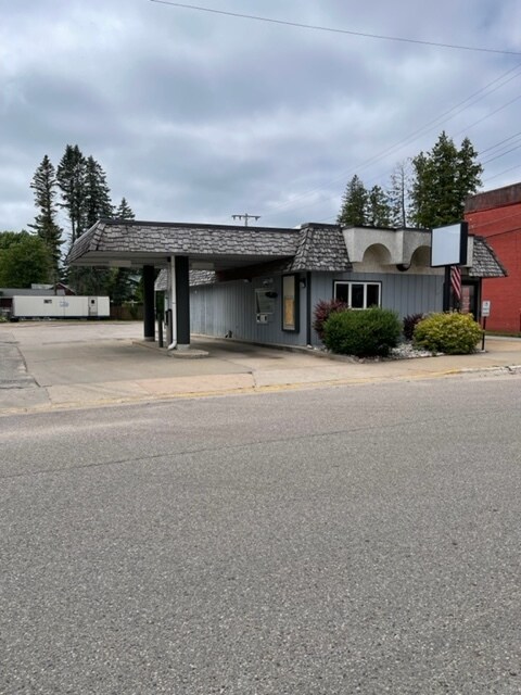
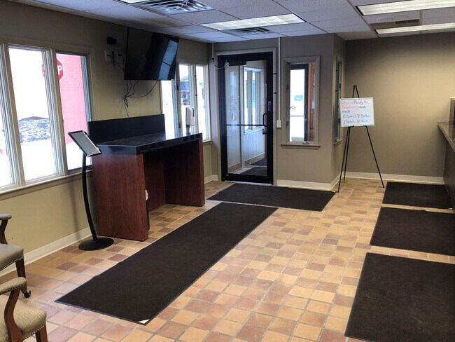
Property Record
6232 River St, Alanson, MI 49706

Property Detail
6232 River St
41-17-10-301-034
PT OF E ? OF BLK 6, VILLAGE OF ALANSON PLAT, COM AT NW COR OF E ? OF SD BLK 6,TH E?LY ON S LN OF RIVER ST 50 FT, TH S?LY PAR
Commercialnec
Emmet
VOA B-1
Michigan
2024
0.09 AC
2025
Michigan North Central Area
970500
Other Market Areas
1,344 SF
Petoskey, MI
NEARBY LISTINGS FOR SALE OR LEASE
-
-
View all Alanson listings for sale on LoopNet.com
DEMOGRAPHICS near 6232 River St
1 mile
3 mile
5 mile
2025 Total Population
1,542
3,125
6,685
2030 Population
1,512
3,067
6,605
Pop Growth 2025-2030
(1.95%)
(1.86%)
(1.20%)
Average Age
42
42
42
2025 Total Households
628
1,272
2,684
HH Growth 2025-2030
(2.07%)
(2.04%)
(1.45%)
Median Household Inc
$69,694
$72,333
$78,084
Avg Household Size
2.40
2.40
2.40
2025 Avg HH Vehicles
2.00
2.00
2.00
Median Home Value
$242,737
$248,275
$256,433
Median Year Built
1987
1985
1986
Nearby Places
Map Layers
Map Styles
 Street
 Aerial
Layers
 Traffic
 Biking
Places
Listings with unknown addresses are not visible on the map
- Restaurants
- Banks
- Shops
- Fitness
- Groceries
SALE & LEASE HISTORY
LISTING DATE
SALE/LEASE

Jul 06, 2022
For Sale
Nearby Properties
Address
Land Use
TOTAL SIZE
Lot Size
Zoning
Address
Land Use
TOTAL SIZE
Lot Size
Zoning
42,382 SF
18.34 AC
EC SR
Address
Land Use
TOTAL SIZE
Lot Size
Zoning
8,160 SF
4.80 AC
EC FF-1
Address
Land Use
TOTAL SIZE
Lot Size
Zoning
7,197 SF
4.29 AC
EC B-1
Address
Land Use
TOTAL SIZE
Lot Size
Zoning
15,392 SF
3 AC
VOA R-1A
Address
Land Use
TOTAL SIZE
Lot Size
Zoning
5.37 AC
EC RR
Address
Land Use
TOTAL SIZE
Lot Size
Zoning
4,056 SF
17.11 AC
VOA PUD
Address
Land Use
TOTAL SIZE
Lot Size
Zoning
2,842 SF
1.81 AC
EC B-3
Address
Land Use
TOTAL SIZE
Lot Size
Zoning
9,000 SF
5 AC
VOA B-2
Address
Land Use
TOTAL SIZE
Lot Size
Zoning
6,004 SF
4.80 AC
EC FF-1
Address
Land Use
TOTAL SIZE
Lot Size
Zoning
5,480 SF
0.17 AC
VOA B-1
Address
Land Use
TOTAL SIZE
Lot Size
Zoning
75 AC
EC FF-1
Address
Land Use
TOTAL SIZE
Lot Size
Zoning
1.01 AC
EC I-1
Address
Land Use
TOTAL SIZE
Lot Size
Zoning
Address
Land Use
TOTAL SIZE
Lot Size
Zoning
3.80 AC
EC R-2
Address
Land Use
TOTAL SIZE
Lot Size
Zoning
0.80 AC
EC RR
Address
Land Use
TOTAL SIZE
Lot Size
Zoning
7,200 SF
1.29 AC
VOA PT
Address
Land Use
TOTAL SIZE
Lot Size
Zoning
1,520 SF
37.95 AC
EC FF-1
Address
Land Use
TOTAL SIZE
Lot Size
Zoning
13.89 AC
EC R-2
Address
Land Use
TOTAL SIZE
Lot Size
Zoning
3,129 SF
0.38 AC
VOA PT
Address
Land Use
TOTAL SIZE
Lot Size
Zoning
VOA B-2
Address
Land Use
TOTAL SIZE
Lot Size
Zoning
131 SF
EC FF-1
Address
Land Use
TOTAL SIZE
Lot Size
Zoning
1.56 AC
Address
Land Use
TOTAL SIZE
Lot Size
Zoning
2,612 SF
76.25 AC
EC FF-1
Address
Land Use
TOTAL SIZE
Lot Size
Zoning
9,224 SF
9.51 AC
EC FF-1
Address
Land Use
TOTAL SIZE
Lot Size
Zoning
5,858 SF
14.76 AC
EC FF-1
Address
Land Use
TOTAL SIZE
Lot Size
Zoning
EC R-1
Address
Land Use
TOTAL SIZE
Lot Size
Zoning
5.53 AC
EC RR
Address
Land Use
TOTAL SIZE
Lot Size
Zoning
EC R-1
Address
Land Use
TOTAL SIZE
Lot Size
Zoning
1,700 SF
21.66 AC
EC FF-1
Address
Land Use
TOTAL SIZE
Lot Size
Zoning
2,520 SF
0.32 AC
VOA PT
The World's #1 Commercial Real Estate Marketplace
Connect with us
© 2026 CoStar Group
The information above has been obtained from sources believed reliable. While we do not doubt its accuracy we have not verified it and make no guarantee, warranty or representation about it. It is your responsibility to independently confirm its accuracy and completeness. Any projections, opinions, assumptions, or estimates used are for example only and do not represent the current or future performance of the property. The value of this transaction to you depends on tax and other factors which should be evaluated by your tax, financial, and legal advisors. You and your advisors should conduct a careful, independent investigation of the property to determine to your satisfaction the suitability of the property for your needs.