Property Record
6233 Veterans Blvd S, Fargo, ND 58104
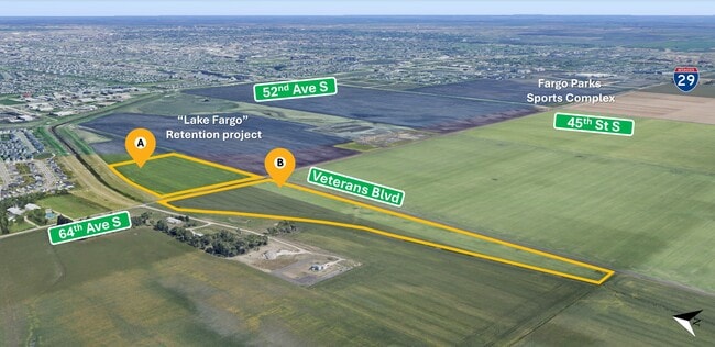
This Property Is For Sale
NEARBY LISTINGS FOR SALE OR LEASE
-
-
-
County Road 17 @ Christianson Boulevard
Horace, ND 58047
$2,551,572 - $9,232,768
4.88 - 9.84 AC Lot
Land
-
-
-
-
-
View all Fargo listings for sale on LoopNet.com
Property Detail
6233 Veterans Blvd S
Fargo, ND-MN
Unplatted
01-3517-00110-000
LOT: 0 BLOCK: 5 ADDITION: UNPLATTED ADDITIONAL: UNPLATTED 5-138-49 27.70 AC THAT PT OF SE1/4 OF SE1/4 LYING E OF DRAINAGE
Agriculturalland
Cass
AE
North Dakota
38017C0767G
27.70 AC
2024
Fargo
2024
Other Market Areas
040504
DEMOGRAPHICS near 6233 Veterans Blvd S
1 Mile
3 Mile
5 Mile
2024 Total Population
1,803
41,359
104,226
2029 Population
1,775
44,703
112,053
Pop Growth 2024-2029
(1.55%)
+ 8.09%
+ 7.51%
Average Age
29
33
35
2024 Total Households
594
15,779
43,102
HH Growth 2024-2029
(1.18%)
+ 8.69%
+ 7.95%
Median Household Inc
$130,769
$99,695
$79,015
Avg Household Size
3.00
2.60
2.40
2024 Avg HH Vehicles
2.00
2.00
2.00
Median Home Value
$347,904
$346,182
$310,383
Median Year Built
2011
2010
2007
Nearby Places
Map Layers
Map Styles
 Street
 Aerial
- Restaurants
- Banks
- Shops
- Fitness
- Groceries
PUBLIC TRANSPORTATION
AIRPORT
Hector International
DRIVE
WALK
Distance
Hector International
24 min
14.3 mi
Freight Ports
Port Milwaukee
DRIVE
WALK
Distance
Port Milwaukee
639 min
579.8 mi
Nearby Properties
Address
Land Use
TOTAL SIZE
Lot Size
Zoning
Address
Land Use
TOTAL SIZE
Lot Size
Zoning
55.68 AC
Address
Land Use
TOTAL SIZE
Lot Size
Zoning
Address
Land Use
TOTAL SIZE
Lot Size
Zoning
Address
Land Use
TOTAL SIZE
Lot Size
Zoning
7.66 AC
Address
Land Use
TOTAL SIZE
Lot Size
Zoning
Address
Land Use
TOTAL SIZE
Lot Size
Zoning
Address
Land Use
TOTAL SIZE
Lot Size
Zoning
9,279 SF
8.33 AC
MR1
Address
Land Use
TOTAL SIZE
Lot Size
Zoning
30,240 SF
1.54 AC
MR2
Address
Land Use
TOTAL SIZE
Lot Size
Zoning
73,907 SF
3.41 AC
MR3
Address
Land Use
TOTAL SIZE
Lot Size
Zoning
152,918 SF
5.38 AC
Address
Land Use
TOTAL SIZE
Lot Size
Zoning
122,201 SF
8.92 AC
GO
Address
Land Use
TOTAL SIZE
Lot Size
Zoning
191,151 SF
22.98 AC
LC
Address
Land Use
TOTAL SIZE
Lot Size
Zoning
54,927 SF
8.45 AC
Address
Land Use
TOTAL SIZE
Lot Size
Zoning
88,956 SF
10.56 AC
GO
Address
Land Use
TOTAL SIZE
Lot Size
Zoning
160,913 SF
11.46 AC
GC
Address
Land Use
TOTAL SIZE
Lot Size
Zoning
Address
Land Use
TOTAL SIZE
Lot Size
Zoning
42,476 SF
2.07 AC
MR1
Address
Land Use
TOTAL SIZE
Lot Size
Zoning
3.72 AC
Address
Land Use
TOTAL SIZE
Lot Size
Zoning
42,366 SF
Address
Land Use
TOTAL SIZE
Lot Size
Zoning
30,240 SF
8.93 AC
Address
Land Use
TOTAL SIZE
Lot Size
Zoning
38,325 SF
465,408 AC
MR3
Address
Land Use
TOTAL SIZE
Lot Size
Zoning
2.20 AC
Address
Land Use
TOTAL SIZE
Lot Size
Zoning
2.39 AC
Address
Land Use
TOTAL SIZE
Lot Size
Zoning
84,738 SF
4.61 AC
MR3
Address
Land Use
TOTAL SIZE
Lot Size
Zoning
165,824 SF
5.38 AC
MR1
Address
Land Use
TOTAL SIZE
Lot Size
Zoning
Address
Land Use
TOTAL SIZE
Lot Size
Zoning
75,600 SF
3.82 AC
LC
Address
Land Use
TOTAL SIZE
Lot Size
Zoning
1.98 AC
Address
Land Use
TOTAL SIZE
Lot Size
Zoning
Address
Land Use
TOTAL SIZE
Lot Size
Zoning
5.92 AC
The World's #1 Commercial Real Estate Marketplace
Connect with us
© 2026 CoStar Group
The information above has been obtained from sources believed reliable. While we do not doubt its accuracy we have not verified it and make no guarantee, warranty or representation about it. It is your responsibility to independently confirm its accuracy and completeness. Any projections, opinions, assumptions, or estimates used are for example only and do not represent the current or future performance of the property. The value of this transaction to you depends on tax and other factors which should be evaluated by your tax, financial, and legal advisors. You and your advisors should conduct a careful, independent investigation of the property to determine to your satisfaction the suitability of the property for your needs.