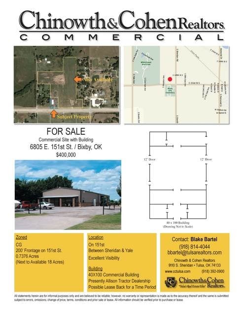
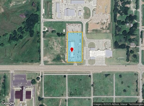
Property Record
6237 E 151St St S, Bixby, OK 74008
NEARBY LISTINGS FOR SALE OR LEASE
Property Detail
6237 E 151St St S
97315-73-15-62910
Unplatted
Warehouse
BEG 790.81W & 135.25N SECR SE SE TH W201 N403.46 E201 S403.40 TO POB LESS E36 S194.75 THEREOF SEC 15 17 13 1.701ACS
X
Tulsa
40143C0433L
Oklahoma
2025
1.70 AC
2025
South Tulsa
007803
Tulsa
4,160 SF
Tulsa, OK
DEMOGRAPHICS near 6237 E 151St St S
1 Mile
3 Mile
5 Mile
2024 Total Population
3,108
20,846
58,732
2029 Population
3,393
22,062
61,262
Pop Growth 2024-2029
+ 9.17%
+ 5.83%
+ 4.31%
Average Age
36
36
38
2024 Total Households
1,061
7,328
20,652
HH Growth 2024-2029
+ 9.05%
+ 5.76%
+ 4.26%
Median Household Inc
$108,437
$89,963
$105,842
Avg Household Size
2.90
2.80
2.80
2024 Avg HH Vehicles
2.00
2.00
2.00
Median Home Value
$317,299
$285,825
$318,095
Median Year Built
2010
2006
2001
Nearby Places
Map Layers
Map Styles
 Street
 Aerial
- Restaurants
- Banks
- Shops
- Fitness
- Groceries
Nearby Properties
Address
Land Use
TOTAL SIZE
Lot Size
Zoning
Address
Land Use
TOTAL SIZE
Lot Size
Zoning
815,589 SF
181.73 AC
AG
Address
Land Use
TOTAL SIZE
Lot Size
Zoning
25,761 SF
15.66 AC
CG
Address
Land Use
TOTAL SIZE
Lot Size
Zoning
2,281,674 SF
147.83 AC
AG
Address
Land Use
TOTAL SIZE
Lot Size
Zoning
10,745 SF
56.52 AC
RS2
Address
Land Use
TOTAL SIZE
Lot Size
Zoning
27,256 SF
31.19 AC
CS
Address
Land Use
TOTAL SIZE
Lot Size
Zoning
36,440 SF
75.39 AC
AG
Address
Land Use
TOTAL SIZE
Lot Size
Zoning
18,161 SF
4.36 AC
AG
Address
Land Use
TOTAL SIZE
Lot Size
Zoning
30,000 SF
5.13 AC
CS
Address
Land Use
TOTAL SIZE
Lot Size
Zoning
237,090 SF
19.84 AC
AG
Address
Land Use
TOTAL SIZE
Lot Size
Zoning
51,200 SF
16.76 AC
AG
Address
Land Use
TOTAL SIZE
Lot Size
Zoning
243,504 SF
13.97 AC
RM3
Address
Land Use
TOTAL SIZE
Lot Size
Zoning
22,760 SF
11.76 AC
AG
Address
Land Use
TOTAL SIZE
Lot Size
Zoning
17,776 SF
0.75 AC
CH
Address
Land Use
TOTAL SIZE
Lot Size
Zoning
26,530 SF
0.81 AC
IL
Address
Land Use
TOTAL SIZE
Lot Size
Zoning
23,375 SF
5.91 AC
CS
Address
Land Use
TOTAL SIZE
Lot Size
Zoning
37,009 SF
4.18 AC
RS1
Address
Land Use
TOTAL SIZE
Lot Size
Zoning
12,156 SF
1.76 AC
CS
Address
Land Use
TOTAL SIZE
Lot Size
Zoning
36,312 SF
3.50 AC
CG
Address
Land Use
TOTAL SIZE
Lot Size
Zoning
42.46 AC
NCU
Address
Land Use
TOTAL SIZE
Lot Size
Zoning
8,912 SF
1.44 AC
CG
Address
Land Use
TOTAL SIZE
Lot Size
Zoning
13,870 SF
9.49 AC
RS3
Address
Land Use
TOTAL SIZE
Lot Size
Zoning
10,086 SF
0.82 AC
CH
Address
Land Use
TOTAL SIZE
Lot Size
Zoning
15,201 SF
0.60 AC
CH
Address
Land Use
TOTAL SIZE
Lot Size
Zoning
36,954 SF
4.01 AC
RM3
Address
Land Use
TOTAL SIZE
Lot Size
Zoning
2,160 SF
10 AC
AG
Address
Land Use
TOTAL SIZE
Lot Size
Zoning
99,507 SF
11.64 AC
CG
Address
Land Use
TOTAL SIZE
Lot Size
Zoning
1,026 SF
14.98 AC
AG
Address
Land Use
TOTAL SIZE
Lot Size
Zoning
74,069 SF
3.29 AC
CG
Address
Land Use
TOTAL SIZE
Lot Size
Zoning
19,332 SF
1.13 AC
CH
Address
Land Use
TOTAL SIZE
Lot Size
Zoning
6,800 SF
6.23 AC
AG
The World's #1 Commercial Real Estate Marketplace
Connect with us
© 2025 CoStar Group
The information above has been obtained from sources believed reliable. While we do not doubt its accuracy we have not verified it and make no guarantee, warranty or representation about it. It is your responsibility to independently confirm its accuracy and completeness. Any projections, opinions, assumptions, or estimates used are for example only and do not represent the current or future performance of the property. The value of this transaction to you depends on tax and other factors which should be evaluated by your tax, financial, and legal advisors. You and your advisors should conduct a careful, independent investigation of the property to determine to your satisfaction the suitability of the property for your needs.