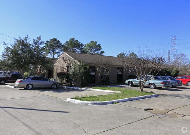
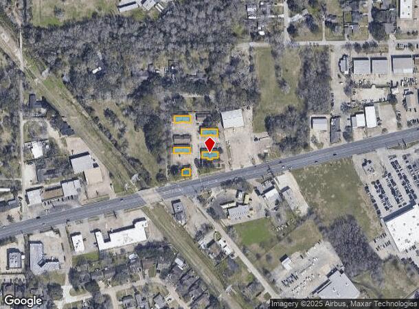
Property Record
610 W Main St, League City, TX 77573
NEARBY LISTINGS FOR SALE OR LEASE
Property Detail
610 W Main St
Houston-The Woodlands-Sugar Land, TX
Clear Creek Blk L
2570-0012-0000-050
ABST 3 S F AUSTIN SUR PT OF BLK L BLDGS B, C, E2, F & H (12-0-50) CLEAR CREEK SUB
Commercialnec
Galveston
X
Texas
48167C0038G
12
2024
0.25 AC
2025
NASA/Clear Lake
720701
Houston
10,720 SF
DEMOGRAPHICS near 610 W Main St
1 Mile
3 Mile
5 Mile
2024 Total Population
7,185
71,450
199,816
2029 Population
7,454
73,769
205,961
Pop Growth 2024-2029
+ 3.74%
+ 3.25%
+ 3.08%
Average Age
37
37
37
2024 Total Households
2,742
27,464
76,584
HH Growth 2024-2029
+ 4.08%
+ 3.29%
+ 3.13%
Median Household Inc
$80,853
$89,751
$86,216
Avg Household Size
2.50
2.50
2.50
2024 Avg HH Vehicles
2.00
2.00
2.00
Median Home Value
$262,170
$295,746
$267,566
Median Year Built
1984
1995
1991
Nearby Places
- Restaurants
- Banks
- Shops
- Fitness
- Groceries
PUBLIC TRANSPORTATION
AIRPORT
William P Hobby
DRIVE
WALK
Distance
William P Hobby
26 min
17.2 mi
Freight Ports
Port of Houston
DRIVE
WALK
Distance
Port of Houston
1 min
18.5 mi
SALE & LEASE HISTORY
LISTING DATE
SALE/LEASE

Feb 13, 2023
For Lease
Nearby Properties
Address
Land Use
TOTAL SIZE
Lot Size
Zoning
Address
Land Use
TOTAL SIZE
Lot Size
Zoning
417,305 SF
32.01 AC
Address
Land Use
TOTAL SIZE
Lot Size
Zoning
544,605 SF
27.49 AC
Address
Land Use
TOTAL SIZE
Lot Size
Zoning
538,570 SF
16.15 AC
Address
Land Use
TOTAL SIZE
Lot Size
Zoning
502,791 SF
123.05 AC
Address
Land Use
TOTAL SIZE
Lot Size
Zoning
218,198 SF
7.27 AC
Address
Land Use
TOTAL SIZE
Lot Size
Zoning
452,269 SF
29.63 AC
Address
Land Use
TOTAL SIZE
Lot Size
Zoning
530,696 SF
8.57 AC
Address
Land Use
TOTAL SIZE
Lot Size
Zoning
366,202 SF
32.55 AC
Address
Land Use
TOTAL SIZE
Lot Size
Zoning
366,500 SF
21.88 AC
Address
Land Use
TOTAL SIZE
Lot Size
Zoning
485,863 SF
4.81 AC
Address
Land Use
TOTAL SIZE
Lot Size
Zoning
312,331 SF
16.10 AC
Address
Land Use
TOTAL SIZE
Lot Size
Zoning
437,909 SF
27.06 AC
Address
Land Use
TOTAL SIZE
Lot Size
Zoning
441,889 SF
17.88 AC
Address
Land Use
TOTAL SIZE
Lot Size
Zoning
282,246 SF
19.56 AC
Address
Land Use
TOTAL SIZE
Lot Size
Zoning
334,876 SF
0.86 AC
Address
Land Use
TOTAL SIZE
Lot Size
Zoning
879,410 SF
93.36 AC
Address
Land Use
TOTAL SIZE
Lot Size
Zoning
340,198 SF
18.69 AC
Address
Land Use
TOTAL SIZE
Lot Size
Zoning
364,008 SF
21.78 AC
Address
Land Use
TOTAL SIZE
Lot Size
Zoning
428,859 SF
23.20 AC
Address
Land Use
TOTAL SIZE
Lot Size
Zoning
126,874 SF
3.92 AC
Address
Land Use
TOTAL SIZE
Lot Size
Zoning
470,930 SF
16.55 AC
Address
Land Use
TOTAL SIZE
Lot Size
Zoning
349,698 SF
20.46 AC
Address
Land Use
TOTAL SIZE
Lot Size
Zoning
17,784 SF
37.39 AC
Address
Land Use
TOTAL SIZE
Lot Size
Zoning
319,572 SF
9.54 AC
Address
Land Use
TOTAL SIZE
Lot Size
Zoning
321,584 SF
15.45 AC
Address
Land Use
TOTAL SIZE
Lot Size
Zoning
5 SF
12.63 AC
Address
Land Use
TOTAL SIZE
Lot Size
Zoning
104,720 SF
4.57 AC
Address
Land Use
TOTAL SIZE
Lot Size
Zoning
47.89 AC
Address
Land Use
TOTAL SIZE
Lot Size
Zoning
325,084 SF
23.74 AC
Address
Land Use
TOTAL SIZE
Lot Size
Zoning
175,000 SF
29.99 AC
The World's #1 Commercial Real Estate Marketplace
Connect with us
© 2025 CoStar Group
The information above has been obtained from sources believed reliable. While we do not doubt its accuracy we have not verified it and make no guarantee, warranty or representation about it. It is your responsibility to independently confirm its accuracy and completeness. Any projections, opinions, assumptions, or estimates used are for example only and do not represent the current or future performance of the property. The value of this transaction to you depends on tax and other factors which should be evaluated by your tax, financial, and legal advisors. You and your advisors should conduct a careful, independent investigation of the property to determine to your satisfaction the suitability of the property for your needs.