Property Record
6240 S Us Highway 1, Grant, FL 32949


NEARBY LISTINGS FOR SALE OR LEASE
-
-
View all Grant listings for sale on LoopNet.com
Property Detail
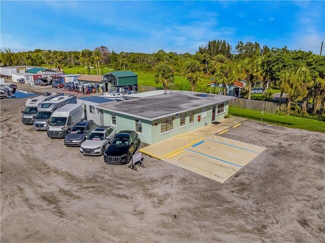
6240 S Us Highway 1
Palm Bay-Melbourne-Titusville, FL
Garretts
29-38-34-00-00508.0-0000.00
PART OF N 300 FT OF S 525 FT OF GOVT LOT 3 W OF HWY AS DESC IN DB 336 PG 462 EXC ORB 101 PG 362, 318 PG 650, 10102 PG 1358
Storageyardjunkautowreckingsalvage
Brevard
AE
Florida
12009C0692H
3
2024
3.47 AC
2025
Brevard County
065236
Orlando
1,152 SF
DEMOGRAPHICS near 6240 S Us Highway 1
1 Mile
3 Mile
5 Mile
2024 Total Population
663
14,275
20,081
2029 Population
768
15,937
22,353
Pop Growth 2024-2029
+ 15.84%
+ 11.64%
+ 11.31%
Average Age
52
61
59
2024 Total Households
284
7,527
10,305
HH Growth 2024-2029
+ 15.49%
+ 11.37%
+ 11.08%
Median Household Inc
$95,651
$52,684
$54,867
Avg Household Size
2.30
1.90
1.90
2024 Avg HH Vehicles
2.00
2.00
2.00
Median Home Value
$389,319
$254,984
$314,086
Median Year Built
2003
1988
1988
Nearby Places
Map Layers
Map Styles
 Street
 Aerial
- Restaurants
- Banks
- Shops
- Fitness
- Groceries
PUBLIC TRANSPORTATION
AIRPORT
Melbourne Orlando International
DRIVE
WALK
Distance
Melbourne Orlando International
30 min
16.6 mi
Freight Ports
Port Canaveral
DRIVE
WALK
Distance
Port Canaveral
68 min
53.0 mi
SALE & LEASE HISTORY
LISTING DATE
SALE/LEASE

Nov 21, 2022
For Sale
Nov 13, 2018
For Sale
Nov 10, 2016
For Sale
Nov 10, 2016
For Lease
May 30, 2019
For Sale
Dec 03, 2019
For Sale
Nearby Properties
Address
Land Use
TOTAL SIZE
Lot Size
Zoning
Address
Land Use
TOTAL SIZE
Lot Size
Zoning
10 AC
GML
Address
Land Use
TOTAL SIZE
Lot Size
Zoning
13.74 AC
GML(P)
Address
Land Use
TOTAL SIZE
Lot Size
Zoning
55,281 SF
8.54 AC
BU1
Address
Land Use
TOTAL SIZE
Lot Size
Zoning
1,600 SF
12.10 AC
GML(H)
Address
Land Use
TOTAL SIZE
Lot Size
Zoning
59,976 SF
5.34 AC
BU2
Address
Land Use
TOTAL SIZE
Lot Size
Zoning
372.56 AC
Address
Land Use
TOTAL SIZE
Lot Size
Zoning
6,823 SF
3.50 AC
GML
Address
Land Use
TOTAL SIZE
Lot Size
Zoning
28,025 SF
19 AC
INL
Address
Land Use
TOTAL SIZE
Lot Size
Zoning
1.75 AC
PUD
Address
Land Use
TOTAL SIZE
Lot Size
Zoning
5,527 SF
2.16 AC
SR
Address
Land Use
TOTAL SIZE
Lot Size
Zoning
18,612 SF
67.22 AC
PA
Address
Land Use
TOTAL SIZE
Lot Size
Zoning
272 SF
0.92 AC
GML-H
Address
Land Use
TOTAL SIZE
Lot Size
Zoning
2,313 SF
7.33 AC
GML
Address
Land Use
TOTAL SIZE
Lot Size
Zoning
1.14 AC
SR
Address
Land Use
TOTAL SIZE
Lot Size
Zoning
8,007 SF
0.76 AC
RU24
Address
Land Use
TOTAL SIZE
Lot Size
Zoning
1.19 AC
RU24
Address
Land Use
TOTAL SIZE
Lot Size
Zoning
10,866 SF
2.33 AC
GML
Address
Land Use
TOTAL SIZE
Lot Size
Zoning
3.40 AC
RR-1
Address
Land Use
TOTAL SIZE
Lot Size
Zoning
5,064 SF
0.61 AC
SR
Address
Land Use
TOTAL SIZE
Lot Size
Zoning
8,108 SF
0.85 AC
RU19
Address
Land Use
TOTAL SIZE
Lot Size
Zoning
17,250 SF
3.51 AC
BU1
Address
Land Use
TOTAL SIZE
Lot Size
Zoning
17,655 SF
3.76 AC
BU1A
Address
Land Use
TOTAL SIZE
Lot Size
Zoning
6,357 SF
0.33 AC
RU113
Address
Land Use
TOTAL SIZE
Lot Size
Zoning
11,275 SF
2 AC
AU
Address
Land Use
TOTAL SIZE
Lot Size
Zoning
1.25 AC
RR1
Address
Land Use
TOTAL SIZE
Lot Size
Zoning
21,225 SF
2.83 AC
IU1
Address
Land Use
TOTAL SIZE
Lot Size
Zoning
6,149 SF
0.69 AC
RU24
Address
Land Use
TOTAL SIZE
Lot Size
Zoning
0.51 AC
RU-2-4
Address
Land Use
TOTAL SIZE
Lot Size
Zoning
2,677 SF
0.64 AC
SR
Address
Land Use
TOTAL SIZE
Lot Size
Zoning
76.30 AC
GML
The World's #1 Commercial Real Estate Marketplace
Connect with us
© 2026 CoStar Group
The information above has been obtained from sources believed reliable. While we do not doubt its accuracy we have not verified it and make no guarantee, warranty or representation about it. It is your responsibility to independently confirm its accuracy and completeness. Any projections, opinions, assumptions, or estimates used are for example only and do not represent the current or future performance of the property. The value of this transaction to you depends on tax and other factors which should be evaluated by your tax, financial, and legal advisors. You and your advisors should conduct a careful, independent investigation of the property to determine to your satisfaction the suitability of the property for your needs.