Property Record
6245 Hunt Rd, Pleasant Garden, NC 27313
NEARBY LISTINGS FOR SALE OR LEASE
-
-
View all Pleasant Garden listings for sale on LoopNet.com
Property Detail
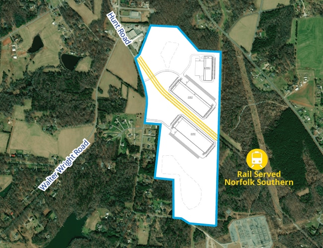
6245 Hunt Rd
Greensboro-High Point, NC
Hardin
0131961
67.86 AC HARDIN SR3437
Vacantlandnec
Guilford
X
North Carolina
3710787000J
1
2024
75.27 AC
2025
SE Guilford County
016900
Greensboro/Winston-Salem
DEMOGRAPHICS near 6245 Hunt Rd
1 Mile
3 Mile
5 Mile
2024 Total Population
726
6,626
29,998
2029 Population
713
6,531
29,910
Pop Growth 2024-2029
(1.79%)
(1.43%)
(0.29%)
Average Age
47
44
42
2024 Total Households
284
2,642
12,126
HH Growth 2024-2029
(2.11%)
(1.40%)
(0.31%)
Median Household Inc
$86,309
$81,186
$68,365
Avg Household Size
2.50
2.50
2.40
2024 Avg HH Vehicles
2.00
2.00
2.00
Median Home Value
$225,238
$215,349
$193,829
Median Year Built
1977
1983
1988
Nearby Places
Map Layers
Map Styles
 Street
 Aerial
- Restaurants
- Banks
- Shops
- Fitness
- Groceries
PUBLIC TRANSPORTATION
COMMUTER RAIL
Greensboro Station (Piedmont - North Carolina by Train (NC Train))
DRIVE
WALK
Distance
Greensboro Station (Piedmont - North Carolina by Train (NC Train))
16 min
9.3 mi
AIRPORT
Piedmont Triad International
DRIVE
WALK
Distance
Piedmont Triad International
32 min
18.4 mi
Freight Ports
Port of Wilmington
DRIVE
WALK
Distance
Port of Wilmington
243 min
178.2 mi
Nearby Properties
Address
Land Use
TOTAL SIZE
Lot Size
Zoning
Address
Land Use
TOTAL SIZE
Lot Size
Zoning
11,630 SF
404.51 AC
PI
Address
Land Use
TOTAL SIZE
Lot Size
Zoning
97,679 SF
17.18 AC
PI
Address
Land Use
TOTAL SIZE
Lot Size
Zoning
112,960 SF
23.36 AC
PI
Address
Land Use
TOTAL SIZE
Lot Size
Zoning
49,728 SF
9.29 AC
PI
Address
Land Use
TOTAL SIZE
Lot Size
Zoning
177,610 SF
13.19 AC
LI
Address
Land Use
TOTAL SIZE
Lot Size
Zoning
7,804 SF
48.71 AC
PI
Address
Land Use
TOTAL SIZE
Lot Size
Zoning
14,856 SF
10.01 AC
RS-40
Address
Land Use
TOTAL SIZE
Lot Size
Zoning
30,482 SF
2.17 AC
PI
Address
Land Use
TOTAL SIZE
Lot Size
Zoning
13,121 SF
2.34 AC
HB
Address
Land Use
TOTAL SIZE
Lot Size
Zoning
4,789 SF
40.01 AC
HI
Address
Land Use
TOTAL SIZE
Lot Size
Zoning
208 AC
HI
Address
Land Use
TOTAL SIZE
Lot Size
Zoning
8,129 SF
2.78 AC
HB
Address
Land Use
TOTAL SIZE
Lot Size
Zoning
16,447 SF
5.10 AC
HB
Address
Land Use
TOTAL SIZE
Lot Size
Zoning
18,238 SF
25.76 AC
RS-40
Address
Land Use
TOTAL SIZE
Lot Size
Zoning
13,264 SF
10.01 AC
RS-40
Address
Land Use
TOTAL SIZE
Lot Size
Zoning
14,646 SF
2.18 AC
HB
Address
Land Use
TOTAL SIZE
Lot Size
Zoning
35,107 SF
7.14 AC
HI
Address
Land Use
TOTAL SIZE
Lot Size
Zoning
4,434 SF
95.50 AC
AG
Address
Land Use
TOTAL SIZE
Lot Size
Zoning
6,084 SF
4.38 AC
RS-40
Address
Land Use
TOTAL SIZE
Lot Size
Zoning
3,786 SF
109.51 AC
AG
Address
Land Use
TOTAL SIZE
Lot Size
Zoning
4,828 SF
86.43 AC
AG
Address
Land Use
TOTAL SIZE
Lot Size
Zoning
1,934 SF
114.93 AC
AG
Address
Land Use
TOTAL SIZE
Lot Size
Zoning
186.03 AC
AG
Address
Land Use
TOTAL SIZE
Lot Size
Zoning
6,040 SF
20.09 AC
PI
Address
Land Use
TOTAL SIZE
Lot Size
Zoning
2,978 SF
86.12 AC
AG
Address
Land Use
TOTAL SIZE
Lot Size
Zoning
170.71 AC
AG
Address
Land Use
TOTAL SIZE
Lot Size
Zoning
2,564 SF
111.85 AC
AG
Address
Land Use
TOTAL SIZE
Lot Size
Zoning
1,464 SF
67.86 AC
HI
Address
Land Use
TOTAL SIZE
Lot Size
Zoning
205,501 SF
7.60 AC
HI
The World's #1 Commercial Real Estate Marketplace
Connect with us
© 2025 CoStar Group
The information above has been obtained from sources believed reliable. While we do not doubt its accuracy we have not verified it and make no guarantee, warranty or representation about it. It is your responsibility to independently confirm its accuracy and completeness. Any projections, opinions, assumptions, or estimates used are for example only and do not represent the current or future performance of the property. The value of this transaction to you depends on tax and other factors which should be evaluated by your tax, financial, and legal advisors. You and your advisors should conduct a careful, independent investigation of the property to determine to your satisfaction the suitability of the property for your needs.