Property Record
62495 Route 25, Southold, NY 11971
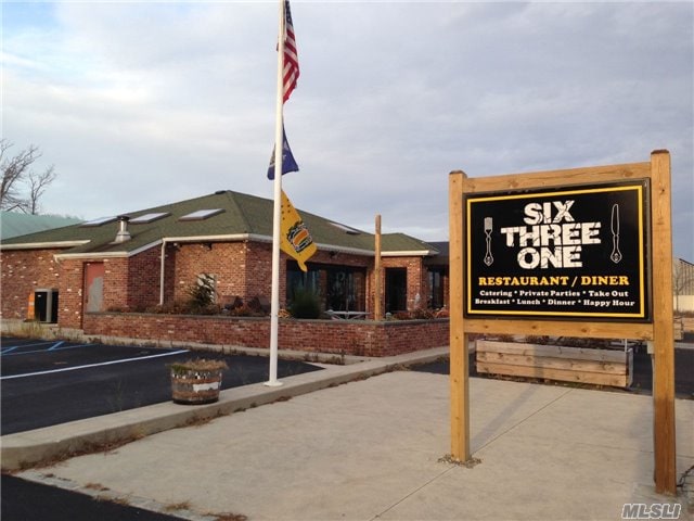
This Property Is For Sale
NEARBY LISTINGS FOR SALE OR LEASE
Property Detail
62495 Route 25
Nassau County-Suffolk County, NY
South Ferry Home
1000-056-00-04-00-007-000
ARREARS PRIOR TAX ARREARS
Residentialacreage
Suffolk
X
New York
36103C0159H
5
2024
0.11 AC
2024
Eastern Suffolk
170204
Long Island (New York)
DEMOGRAPHICS near 62495 Route 25
1 Mile
3 Mile
5 Mile
2024 Total Population
1,100
12,120
19,972
2029 Population
1,128
12,459
20,558
Pop Growth 2024-2029
+ 2.55%
+ 2.80%
+ 2.93%
Average Age
48
48
48
2024 Total Households
465
5,149
8,627
HH Growth 2024-2029
+ 2.37%
+ 2.74%
+ 2.92%
Median Household Inc
$92,592
$93,288
$92,289
Avg Household Size
2.30
2.30
2.30
2024 Avg HH Vehicles
2.00
2.00
2.00
Median Home Value
$682,403
$752,848
$761,517
Median Year Built
1977
1971
1972
Nearby Places
- Restaurants
- Banks
- Shops
- Fitness
- Groceries
PUBLIC TRANSPORTATION
COMMUTER RAIL
Southold Station (Greenport Branch - Long Island Rail Road)
DRIVE
WALK
Distance
Southold Station (Greenport Branch - Long Island Rail Road)
3 min
1.6 mi
Greenport Station (Greenport Branch - Long Island Rail Road)
DRIVE
WALK
Distance
Greenport Station (Greenport Branch - Long Island Rail Road)
6 min
3.2 mi
Freight Ports
Port of New Haven
DRIVE
WALK
Distance
Port of New Haven
170 min
75.4 mi
Nearby Properties
Address
Land Use
TOTAL SIZE
Lot Size
Zoning
Address
Land Use
TOTAL SIZE
Lot Size
Zoning
9,468 SF
3.20 AC
AA
Address
Land Use
TOTAL SIZE
Lot Size
Zoning
8.70 AC
AA
Address
Land Use
TOTAL SIZE
Lot Size
Zoning
2,076 SF
42.20 AC
AA
Address
Land Use
TOTAL SIZE
Lot Size
Zoning
904 SF
20.30 AC
AA
Address
Land Use
TOTAL SIZE
Lot Size
Zoning
1,284 SF
11.38 AC
C
Address
Land Use
TOTAL SIZE
Lot Size
Zoning
2,000 SF
0.54 AC
B
Address
Land Use
TOTAL SIZE
Lot Size
Zoning
7,022 SF
0.70 AC
C
Address
Land Use
TOTAL SIZE
Lot Size
Zoning
0.74 AC
AA
Address
Land Use
TOTAL SIZE
Lot Size
Zoning
11.70 AC
C
Address
Land Use
TOTAL SIZE
Lot Size
Zoning
10,250 SF
10.10 AC
C
Address
Land Use
TOTAL SIZE
Lot Size
Zoning
38.11 AC
R-40 RO
Address
Land Use
TOTAL SIZE
Lot Size
Zoning
778 SF
7.68 AC
AA
Address
Land Use
TOTAL SIZE
Lot Size
Zoning
4.12 AC
AA
Address
Land Use
TOTAL SIZE
Lot Size
Zoning
3,910 SF
0.30 AC
B
Address
Land Use
TOTAL SIZE
Lot Size
Zoning
3,709 SF
0.15 AC
B
Address
Land Use
TOTAL SIZE
Lot Size
Zoning
3,140 SF
0.62 AC
B
Address
Land Use
TOTAL SIZE
Lot Size
Zoning
3,579 SF
0.10 AC
B
Address
Land Use
TOTAL SIZE
Lot Size
Zoning
2,292 SF
0.25 AC
AA
Address
Land Use
TOTAL SIZE
Lot Size
Zoning
4,586 SF
1.10 AC
C
Address
Land Use
TOTAL SIZE
Lot Size
Zoning
1.62 AC
AA
Address
Land Use
TOTAL SIZE
Lot Size
Zoning
4.20 AC
C
Address
Land Use
TOTAL SIZE
Lot Size
Zoning
2,356 SF
0.41 AC
AA
Address
Land Use
TOTAL SIZE
Lot Size
Zoning
5,900 SF
0.12 AC
B
Address
Land Use
TOTAL SIZE
Lot Size
Zoning
1,632 SF
0.36 AC
B
Address
Land Use
TOTAL SIZE
Lot Size
Zoning
7,938 SF
0.41 AC
B1
Address
Land Use
TOTAL SIZE
Lot Size
Zoning
1.80 AC
AA
Address
Land Use
TOTAL SIZE
Lot Size
Zoning
2,698 SF
0.29 AC
B
Address
Land Use
TOTAL SIZE
Lot Size
Zoning
1.70 AC
AA
Address
Land Use
TOTAL SIZE
Lot Size
Zoning
2.30 AC
AA
Address
Land Use
TOTAL SIZE
Lot Size
Zoning
0.64 AC
AA
The World's #1 Commercial Real Estate Marketplace
Connect with us
© 2025 CoStar Group
The information above has been obtained from sources believed reliable. While we do not doubt its accuracy we have not verified it and make no guarantee, warranty or representation about it. It is your responsibility to independently confirm its accuracy and completeness. Any projections, opinions, assumptions, or estimates used are for example only and do not represent the current or future performance of the property. The value of this transaction to you depends on tax and other factors which should be evaluated by your tax, financial, and legal advisors. You and your advisors should conduct a careful, independent investigation of the property to determine to your satisfaction the suitability of the property for your needs.