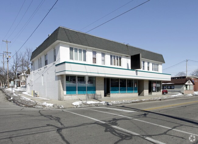
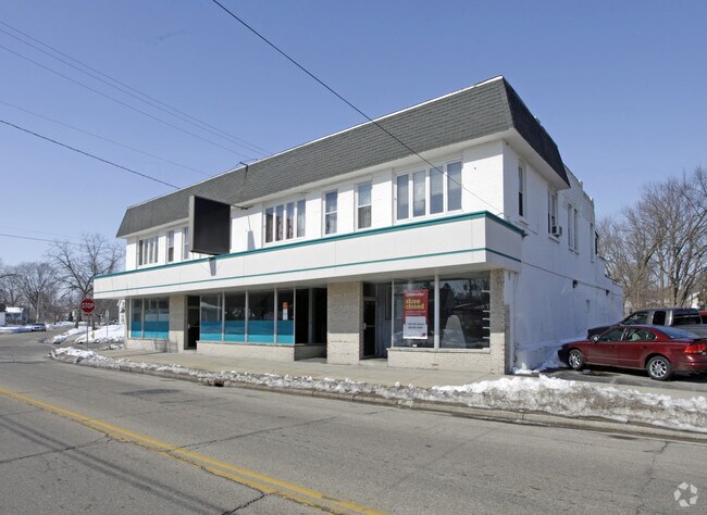
Property Record
625 8Th St, Beloit, WI 53511

Property Detail
625 8Th St
Janesville-Beloit, WI
LOTS 1 AND 2 PIERCES SUB OF HACKETTS ADD, W 60 FT L 83 HACKETTS ADD, LOTS 71 - 75 TENNYS ADD
135-60975
Rock
Municipalproperty
Wisconsin
B and X Area of moderate flood hazard, usually the area between the limits of the 100-year and 500-year floods.
1-2,71
0
2.80 AC
2025
Rock County
001600
Milwaukee/Madison
NEARBY LISTINGS FOR SALE OR LEASE
DEMOGRAPHICS near 625 8Th St
1 mile
3 mile
5 mile
2024 Total Population
14,222
45,121
69,243
2029 Population
14,350
45,497
69,765
Pop Growth 2024-2029
+ 0.90%
+ 0.83%
+ 0.75%
Average Age
36
38
40
2024 Total Households
5,189
17,324
26,950
HH Growth 2024-2029
+ 0.96%
+ 0.84%
+ 0.77%
Median Household Inc
$53,623
$60,571
$70,995
Avg Household Size
2.50
2.50
2.50
2024 Avg HH Vehicles
2.00
2.00
2.00
Median Home Value
$132,527
$156,062
$188,568
Median Year Built
1949
1958
1968
Nearby Places
Map Layers
Map Styles
 Street
 Aerial
Transit
 Traffic
 Biking
Places
Listings with unknown addresses are not visible on the map
- Restaurants
- Banks
- Shops
- Fitness
- Groceries
PUBLIC TRANSPORTATION
AIRPORT
Chicago/Rockford International
Drive
Walk
Distance
Chicago/Rockford International
45 min
32.5 mi
Freight Ports
Port Milwaukee
Drive
Walk
Distance
Port Milwaukee
91 min
75.7 mi
Nearby Properties
Address
Land Use
TOTAL SIZE
Lot Size
Zoning
Address
Land Use
TOTAL SIZE
Lot Size
Zoning
202,676 SF
19.31 AC
Address
Land Use
TOTAL SIZE
Lot Size
Zoning
186,691 SF
17.06 AC
Address
Land Use
TOTAL SIZE
Lot Size
Zoning
3.39 AC
Address
Land Use
TOTAL SIZE
Lot Size
Zoning
3.47 AC
Address
Land Use
TOTAL SIZE
Lot Size
Zoning
3.65 AC
Address
Land Use
TOTAL SIZE
Lot Size
Zoning
361,947 SF
23.26 AC
Address
Land Use
TOTAL SIZE
Lot Size
Zoning
24.15 AC
Address
Land Use
TOTAL SIZE
Lot Size
Zoning
38,012 SF
2.74 AC
Address
Land Use
TOTAL SIZE
Lot Size
Zoning
100,000 SF
14.78 AC
Address
Land Use
TOTAL SIZE
Lot Size
Zoning
16.81 AC
Address
Land Use
TOTAL SIZE
Lot Size
Zoning
32.79 AC
Address
Land Use
TOTAL SIZE
Lot Size
Zoning
89,678 SF
12.90 AC
Address
Land Use
TOTAL SIZE
Lot Size
Zoning
296,731 SF
18.14 AC
Address
Land Use
TOTAL SIZE
Lot Size
Zoning
131,218 SF
1.65 AC
Address
Land Use
TOTAL SIZE
Lot Size
Zoning
48,036 SF
1.26 AC
Address
Land Use
TOTAL SIZE
Lot Size
Zoning
125,000 SF
12.53 AC
Address
Land Use
TOTAL SIZE
Lot Size
Zoning
47,561 SF
0.58 AC
Address
Land Use
TOTAL SIZE
Lot Size
Zoning
10,456 SF
3.58 AC
Address
Land Use
TOTAL SIZE
Lot Size
Zoning
264,754 SF
6.49 AC
Address
Land Use
TOTAL SIZE
Lot Size
Zoning
82,412 SF
3.94 AC
Address
Land Use
TOTAL SIZE
Lot Size
Zoning
57,745 SF
9.57 AC
Address
Land Use
TOTAL SIZE
Lot Size
Zoning
84,000 SF
7.15 AC
Address
Land Use
TOTAL SIZE
Lot Size
Zoning
56,035 SF
5.06 AC
Address
Land Use
TOTAL SIZE
Lot Size
Zoning
45,972 SF
0.64 AC
Address
Land Use
TOTAL SIZE
Lot Size
Zoning
3.27 AC
Address
Land Use
TOTAL SIZE
Lot Size
Zoning
103.62 AC
Address
Land Use
TOTAL SIZE
Lot Size
Zoning
66,654 SF
1.72 AC
Address
Land Use
TOTAL SIZE
Lot Size
Zoning
21,952 SF
2.14 AC
Address
Land Use
TOTAL SIZE
Lot Size
Zoning
21,952 SF
2.14 AC
Address
Land Use
TOTAL SIZE
Lot Size
Zoning
23,715 SF
1.59 AC
The World's #1 Commercial Real Estate Marketplace
Connect with us
© 2026 CoStar Group
The information above has been obtained from sources believed reliable. While we do not doubt its accuracy we have not verified it and make no guarantee, warranty or representation about it. It is your responsibility to independently confirm its accuracy and completeness. Any projections, opinions, assumptions, or estimates used are for example only and do not represent the current or future performance of the property. The value of this transaction to you depends on tax and other factors which should be evaluated by your tax, financial, and legal advisors. You and your advisors should conduct a careful, independent investigation of the property to determine to your satisfaction the suitability of the property for your needs.