Property Record
625 B St, Cheney, WA 99004
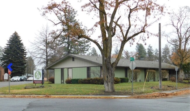
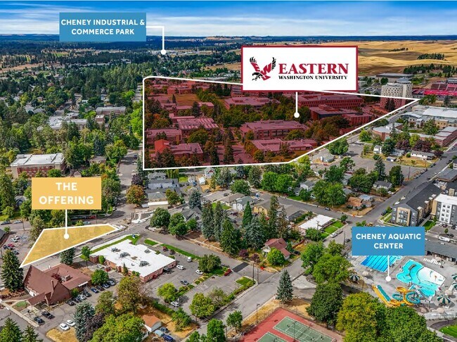
This Property Is For Sale
Property Detail
625 B St
13132.8501
CHENEY 2ND TO TOWN OF L1 B124
Commercialnec
Spokane
R-3
Washington
B and X Area of moderate flood hazard, usually the area between the limits of the 100-year and 500-year floods.
1
2025
0.36 AC
2025
West Plains
014001
Spokane
3,940 SF
Spokane-Spokane Valley, WA
NEARBY LISTINGS FOR SALE OR LEASE
DEMOGRAPHICS near 625 B St
1 mile
3 mile
5 mile
2025 Total Population
10,229
15,241
16,801
2030 Population
10,575
15,691
17,289
Pop Growth 2025-2030
+ 3.38%
+ 2.95%
+ 2.90%
Average Age
32
32
33
2025 Total Households
3,713
5,767
6,346
HH Growth 2025-2030
+ 4.17%
+ 3.43%
+ 3.34%
Median Household Inc
$41,861
$45,685
$51,103
Avg Household Size
2.20
2.30
2.30
2025 Avg HH Vehicles
2.00
2.00
2.00
Median Home Value
$427,907
$412,650
$427,671
Median Year Built
1982
1989
1990
Nearby Places
Map Layers
Map Styles
 Street
 Aerial
Layers
 Traffic
 Biking
Places
Listings with unknown addresses are not visible on the map
- Restaurants
- Banks
- Shops
- Fitness
- Groceries
PUBLIC TRANSPORTATION
AIRPORT
Spokane International
Drive
Walk
Distance
Spokane International
21 min
13.4 mi
Nearby Properties
Address
Land Use
TOTAL SIZE
Lot Size
Zoning
Address
Land Use
TOTAL SIZE
Lot Size
Zoning
410,897 SF
4.38 AC
P
Address
Land Use
TOTAL SIZE
Lot Size
Zoning
375,519 SF
16.62 AC
P
Address
Land Use
TOTAL SIZE
Lot Size
Zoning
265,676 SF
25.25 AC
R-1
Address
Land Use
TOTAL SIZE
Lot Size
Zoning
182,817 SF
13.20 AC
R-3
Address
Land Use
TOTAL SIZE
Lot Size
Zoning
312,332 SF
4.06 AC
P
Address
Land Use
TOTAL SIZE
Lot Size
Zoning
249,952 SF
19.34 AC
R-3
Address
Land Use
TOTAL SIZE
Lot Size
Zoning
228,269 SF
9.43 AC
P
Address
Land Use
TOTAL SIZE
Lot Size
Zoning
196,902 SF
17.05 AC
P
Address
Land Use
TOTAL SIZE
Lot Size
Zoning
61,142 SF
13 AC
R-3H
Address
Land Use
TOTAL SIZE
Lot Size
Zoning
68,755 SF
100 AC
P
Address
Land Use
TOTAL SIZE
Lot Size
Zoning
129,310 SF
34.99 AC
R-1
Address
Land Use
TOTAL SIZE
Lot Size
Zoning
165,284 SF
1.65 AC
P
Address
Land Use
TOTAL SIZE
Lot Size
Zoning
142,588 SF
9.16 AC
R-3
Address
Land Use
TOTAL SIZE
Lot Size
Zoning
106,944 SF
1.89 AC
R-3H
Address
Land Use
TOTAL SIZE
Lot Size
Zoning
46,761 SF
3.09 AC
P
Address
Land Use
TOTAL SIZE
Lot Size
Zoning
66,489 SF
2.34 AC
P
Address
Land Use
TOTAL SIZE
Lot Size
Zoning
33,440 SF
2.59 AC
P
Address
Land Use
TOTAL SIZE
Lot Size
Zoning
109,528 SF
4.17 AC
R-3
Address
Land Use
TOTAL SIZE
Lot Size
Zoning
202,449 SF
23.29 AC
I-1
Address
Land Use
TOTAL SIZE
Lot Size
Zoning
49,872 SF
1.88 AC
P
Address
Land Use
TOTAL SIZE
Lot Size
Zoning
40,361 SF
2.54 AC
C-2
Address
Land Use
TOTAL SIZE
Lot Size
Zoning
55,047 SF
1.26 AC
R-3H
Address
Land Use
TOTAL SIZE
Lot Size
Zoning
81,628 SF
11.88 AC
C-2
Address
Land Use
TOTAL SIZE
Lot Size
Zoning
40,541 SF
3.85 AC
R-3H
Address
Land Use
TOTAL SIZE
Lot Size
Zoning
97,585 SF
0.57 AC
P
Address
Land Use
TOTAL SIZE
Lot Size
Zoning
74,769 SF
2.11 AC
P
Address
Land Use
TOTAL SIZE
Lot Size
Zoning
95,120 SF
4 AC
R-3
Address
Land Use
TOTAL SIZE
Lot Size
Zoning
71,708 SF
4.35 AC
R-3H
Address
Land Use
TOTAL SIZE
Lot Size
Zoning
19,088 SF
2.19 AC
P
Address
Land Use
TOTAL SIZE
Lot Size
Zoning
68,008 SF
4.64 AC
R-3H
The World's #1 Commercial Real Estate Marketplace
Connect with us
© 2026 CoStar Group
The information above has been obtained from sources believed reliable. While we do not doubt its accuracy we have not verified it and make no guarantee, warranty or representation about it. It is your responsibility to independently confirm its accuracy and completeness. Any projections, opinions, assumptions, or estimates used are for example only and do not represent the current or future performance of the property. The value of this transaction to you depends on tax and other factors which should be evaluated by your tax, financial, and legal advisors. You and your advisors should conduct a careful, independent investigation of the property to determine to your satisfaction the suitability of the property for your needs.