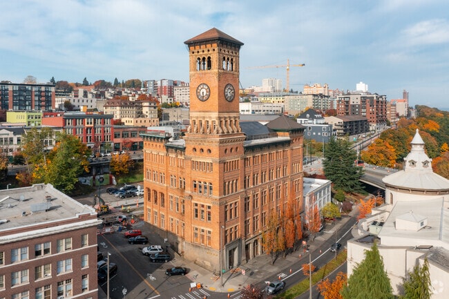
Property Record
625 Commerce St, Tacoma, WA 98402


Current Lease Availabilities
Property Detail
625 Commerce St
032004-2007
SECTION 04 TOWNSHIP 20 RANGE 03 QUARTER 22 : BEG AT A PT ON WLY LI OF PACIFIC AVE 725 FT NLY ALG WLY LI OF PACIFIC AVE FROM C/L OF 9TH ST AS DESIGNATED UPON PLAT ENTITLED MAP OF TACOMA TH WLY ON A LI PAR/W C/L OF S 9TH ST & MORE PARTICULARLY ALG NLY
Officebuilding
Pierce
DCC
Washington
B and X Area of moderate flood hazard, usually the area between the limits of the 100-year and 500-year floods.
0.32 AC
2024
Tacoma CBD
2025
Seattle/Puget Sound
061601
Seattle-Tacoma-Bellevue, WA
55,505 SF
NEARBY LISTINGS FOR SALE OR LEASE
DEMOGRAPHICS near 625 Commerce St
1 mile
3 mile
5 mile
2025 Total Population
20,029
92,398
262,939
2030 Population
20,612
94,890
267,855
Pop Growth 2025-2030
+ 2.91%
+ 2.70%
+ 1.87%
Average Age
40
38
39
2025 Total Households
10,208
38,914
104,524
HH Growth 2025-2030
+ 3.54%
+ 2.90%
+ 2.02%
Median Household Inc
$62,888
$86,306
$90,389
Avg Household Size
1.70
2.20
2.40
2025 Avg HH Vehicles
1.00
2.00
2.00
Median Home Value
$627,924
$561,965
$549,270
Median Year Built
1968
1953
1973
Nearby Places
Map Layers
Map Styles
 Street
 Aerial
Layers
 Traffic
 Biking
Places
Listings with unknown addresses are not visible on the map
- Restaurants
- Banks
- Shops
- Fitness
- Groceries
PUBLIC TRANSPORTATION
TRANSIT/SUBWAY
Old City Hall (Tacoma Dome - St Joseph - Sound Transit)
Drive
Walk
Distance
Old City Hall (Tacoma Dome - St Joseph - Sound Transit)
0 min
0 min
0.1 mi
Theater District/South 9Th (Tacoma Link - Central Puget Sound Regional Transit Authority Rail (Link Light Rail/Sounder))
Drive
Walk
Distance
Theater District/South 9Th (Tacoma Link - Central Puget Sound Regional Transit Authority Rail (Link Light Rail/Sounder))
0 min
1 min
0.1 mi
S 4Th (Tacoma Dome - St Joseph - Sound Transit)
Drive
Walk
Distance
S 4Th (Tacoma Dome - St Joseph - Sound Transit)
1 min
6 min
0.3 mi
Theater District (Tacoma Dome - St Joseph - Sound Transit)
Drive
Walk
Distance
Theater District (Tacoma Dome - St Joseph - Sound Transit)
0 min
6 min
0.3 mi
Convention Center/South 15Th (Tacoma Link - Central Puget Sound Regional Transit Authority Rail (Link Light Rail/Sounder))
Drive
Walk
Distance
Convention Center/South 15Th (Tacoma Link - Central Puget Sound Regional Transit Authority Rail (Link Light Rail/Sounder))
1 min
10 min
0.6 mi
COMMUTER RAIL
Tacoma Dome Station (Sounder South Line - Central Puget Sound Regional Transit Authority Rail (Link Light Rail/Sounder), Tacoma Link - Central Puget Sound Regional Transit Authority Rail (Link Light Rail/Sounder))
Drive
Walk
Distance
Tacoma Dome Station (Sounder South Line - Central Puget Sound Regional Transit Authority Rail (Link Light Rail/Sounder), Tacoma Link - Central Puget Sound Regional Transit Authority Rail (Link Light Rail/Sounder))
3 min
1.8 mi
South Tacoma Station (Seattle - Tacoma/Lakewood - Sound Transit)
Drive
Walk
Distance
South Tacoma Station (Seattle - Tacoma/Lakewood - Sound Transit)
9 min
5.5 mi
AIRPORT
Seattle-Tacoma International
Drive
Walk
Distance
Seattle-Tacoma International
35 min
22.4 mi
Freight Ports
Port of Tacoma
Drive
Walk
Distance
Port of Tacoma
5 min
2.2 mi
Nearby Properties
Address
Land Use
TOTAL SIZE
Lot Size
Zoning
Address
Land Use
TOTAL SIZE
Lot Size
Zoning
1,173,718 SF
79.33 AC
R2
Address
Land Use
TOTAL SIZE
Lot Size
Zoning
756,321 SF
8.90 AC
DMU
Address
Land Use
TOTAL SIZE
Lot Size
Zoning
498,913 SF
1.18 AC
HMX
Address
Land Use
TOTAL SIZE
Lot Size
Zoning
1 SF
83.72 AC
PMI
Address
Land Use
TOTAL SIZE
Lot Size
Zoning
361,000 SF
1.15 AC
HMX
Address
Land Use
TOTAL SIZE
Lot Size
Zoning
326,080 SF
1.67 AC
HMX
Address
Land Use
TOTAL SIZE
Lot Size
Zoning
1 SF
150.54 AC
S10
Address
Land Use
TOTAL SIZE
Lot Size
Zoning
6,794 SF
127.94 AC
S10
Address
Land Use
TOTAL SIZE
Lot Size
Zoning
828,620 SF
40.92 AC
Address
Land Use
TOTAL SIZE
Lot Size
Zoning
161,799 SF
108.15 AC
PMI
Address
Land Use
TOTAL SIZE
Lot Size
Zoning
1 SF
8.63 AC
M2
Address
Land Use
TOTAL SIZE
Lot Size
Zoning
175,800 SF
76.02 AC
PMI
Address
Land Use
TOTAL SIZE
Lot Size
Zoning
220,618 SF
26 AC
DMU
Address
Land Use
TOTAL SIZE
Lot Size
Zoning
138,020 SF
0.93 AC
HMX
Address
Land Use
TOTAL SIZE
Lot Size
Zoning
542,750 SF
26.77 AC
TAC
Address
Land Use
TOTAL SIZE
Lot Size
Zoning
448,900 SF
0.76 AC
DCC
Address
Land Use
TOTAL SIZE
Lot Size
Zoning
10,000 SF
59.94 AC
S10
Address
Land Use
TOTAL SIZE
Lot Size
Zoning
191,430 SF
2.50 AC
PMI
Address
Land Use
TOTAL SIZE
Lot Size
Zoning
1 SF
55.09 AC
PMI
Address
Land Use
TOTAL SIZE
Lot Size
Zoning
18,860 SF
35.98 AC
S10
Address
Land Use
TOTAL SIZE
Lot Size
Zoning
208,168 SF
2.28 AC
HMX
Address
Land Use
TOTAL SIZE
Lot Size
Zoning
1 SF
49.87 AC
S10
Address
Land Use
TOTAL SIZE
Lot Size
Zoning
279,294 SF
74.24 AC
S13
Address
Land Use
TOTAL SIZE
Lot Size
Zoning
157,456 SF
1.19 AC
S8
Address
Land Use
TOTAL SIZE
Lot Size
Zoning
223,447 SF
40.44 AC
RCX
Address
Land Use
TOTAL SIZE
Lot Size
Zoning
416,492 SF
26.05 AC
TAC
Address
Land Use
TOTAL SIZE
Lot Size
Zoning
416,050 SF
18.24 AC
PMI
Address
Land Use
TOTAL SIZE
Lot Size
Zoning
1,424 SF
94.62 AC
S13
Address
Land Use
TOTAL SIZE
Lot Size
Zoning
204,800 SF
47.01 AC
PMI
Address
Land Use
TOTAL SIZE
Lot Size
Zoning
72,000 SF
59.37 AC
PMI
The World's #1 Commercial Real Estate Marketplace
Connect with us
© 2026 CoStar Group
The information above has been obtained from sources believed reliable. While we do not doubt its accuracy we have not verified it and make no guarantee, warranty or representation about it. It is your responsibility to independently confirm its accuracy and completeness. Any projections, opinions, assumptions, or estimates used are for example only and do not represent the current or future performance of the property. The value of this transaction to you depends on tax and other factors which should be evaluated by your tax, financial, and legal advisors. You and your advisors should conduct a careful, independent investigation of the property to determine to your satisfaction the suitability of the property for your needs.